Geolocate

Florø topographic map

Click on the map to display elevation.

About this map

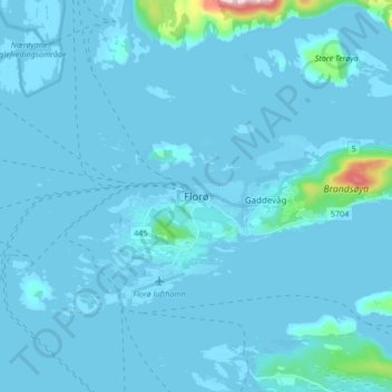
Name: Florø topographic map, elevation, terrain.

Location: Florø, Kinn, Vestland, 6906, Norway (61.56026 4.99496 61.64026 5.07496)

Average elevation: 46 ft

Minimum elevation: -10 ft

Maximum elevation: 1,112 ft

Other topographic maps

Click on a map to view its topography, its elevation and its terrain.

Tysnes

Norway > Vestland

Average elevation: 318 ft

Lærdal

Norway > Vestland

Average elevation: 3,789 ft

Voss

Norway > Vestland

Average elevation: 2,510 ft

Austevoll

Norway > Vestland

Average elevation: 20 ft

Kvam herad

Norway > Vestland

Average elevation: 1,677 ft

Bjørnafjorden

Norway > Vestland

Average elevation: 30 ft

Høyanger

Norway > Vestland

Average elevation: 1,732 ft

Sveio

Norway > Vestland

Average elevation: 187 ft

Vik

Norway > Vestland

Average elevation: 2,425 ft

Sogndal

Norway > Vestland

Average elevation: 2,379 ft

Gear up for your next adventure:

🦟Ultrasonic Repellers - Create a bug-free zone at your camp or rest stop
🏫Relief Map Kits - Hands-on tools for teaching landforms and elevation
🔥Camping Stove - Portable stove for camping and backcountry cooking
🎒Trail Energy Bars - High‑calorie bars for hiking energy
📡GPS Antenna Upgrade - Enhance GPS reception in remote terrain

As an Amazon Associate, this site earns from qualifying purchases at no extra cost to you.