
长岭街道 topographic map
Interactive map
Click on the map to display elevation.
About this map
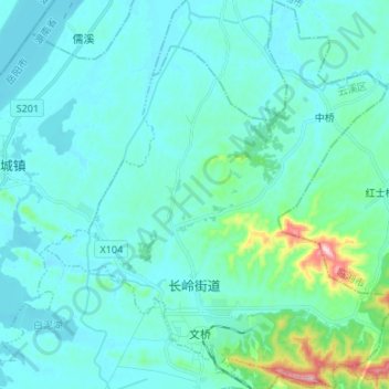
Name: 长岭街道 topographic map, elevation, terrain.
Location: 长岭街道, 云溪区, 岳阳市, 湖南省, 中国 (29.52192 113.30684 29.63782 113.42850)
Average elevation: 187 ft
Minimum elevation: 52 ft
Maximum elevation: 1,145 ft
Other topographic maps
Click on a map to view its topography, its elevation and its terrain.
湘潭市雨湖区渡佳坝工程管理所
湘潭市雨湖区渡佳坝工程管理所, 烧汤河, 响塘乡, 雨湖区, 湘潭市, 湖南省, 中国
Average elevation: 154 ft