
新邵县 topographic map
Interactive map
Click on the map to display elevation.
About this map
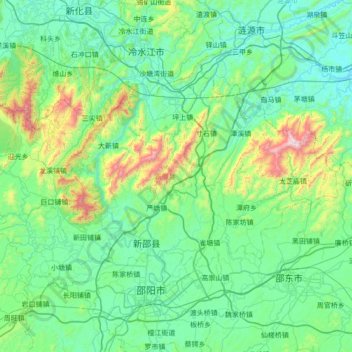
Name: 新邵县 topographic map, elevation, terrain.
Location: 新邵县, 邵阳市, 湖南省, 中国 (27.24370 111.13994 27.63778 111.82958)
Average elevation: 1,122 ft
Minimum elevation: 397 ft
Maximum elevation: 4,747 ft
新邵地处雪峰山脉,雪峰山自西向东穿过全境,主要山峰有龙山 (山峰)、金龙山、板竹山。主要河流为资水及其支流龙山河、石马河、涣溪河、酿溪河、棠溪河、龙口溪河和岱水河。境内地势南高北低,东北、西北以山地为主,东南和西南以丘陵为主;最高点为龙山主峰岳平顶,海拔1513米。
Other topographic maps
Click on a map to view its topography, its elevation and its terrain.
湘潭市雨湖区渡佳坝工程管理所
湘潭市雨湖区渡佳坝工程管理所, 烧汤河, 响塘乡, 雨湖区, 湘潭市, 湖南省, 中国
Average elevation: 154 ft