
Make a donation
Gear up for your next adventure:
As an Amazon Associate, this site earns from qualifying purchases at no extra cost to you.
Cleveland National Forest topographic map
Click on the map to display elevation.
Make a donation
Gear up for your next adventure:
As an Amazon Associate, this site earns from qualifying purchases at no extra cost to you.
Cleveland National Forest
The Cleveland National Forest encompasses 460,000 acres/720 sq mi (1,900 km2) of inland montane regions—approx. 60 miles from the Pacific Ocean—within the counties of San Diego, Riverside, and Orange, California. The landscape varies somewhat, with mostly chaparral canyons, arroyos and high desert, but dotted with meadows and oak and conifer forests. Near water sources, riparian environments and perennial aquatic plants attract native and migratory wildlife, such as at San Diego’s man-made Lake Cuyamaca. A generally warm and dry, inland-Mediterranean climate prevails over the forest, with the cooler months producing morning frost and snowfall (in the higher elevations). It is the southernmost U.S. National Forest of California. The area is administered by the U.S. Forest Service, a government agency within the United States Department of Agriculture, and is locally overseen by the Descanso, Palomar and Trabuco Ranger Districts.
Make a donation
Gear up for your next adventure:
As an Amazon Associate, this site earns from qualifying purchases at no extra cost to you.
About this map
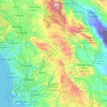
Name: Cleveland National Forest topographic map, elevation, terrain.
Average elevation: 1,955 ft
Minimum elevation: -233 ft
Maximum elevation: 10,492 ft
San Diego County trails, hiking, mountain biking, running and outdoor activities
Make a donation
Gear up for your next adventure:
As an Amazon Associate, this site earns from qualifying purchases at no extra cost to you.
Other topographic maps
Click on a map to view its topography, its elevation and its terrain.
Lake Murray Reservoir
United States > California > San Diego County > San Diego > San Carlos
Average elevation: 584 ft
Rancho Peñasquitos
United States > California > San Diego County > San Diego
The highest point in the community is Black Mountain, which rises to an elevation of 1,500 feet (460 m).
Average elevation: 515 ft
Make a donation
Gear up for your next adventure:
As an Amazon Associate, this site earns from qualifying purchases at no extra cost to you.
Make a donation
Gear up for your next adventure:
As an Amazon Associate, this site earns from qualifying purchases at no extra cost to you.
Independence Park
United States > California > San Diego County > Chula Vista
Average elevation: 436 ft
Make a donation
Gear up for your next adventure:
As an Amazon Associate, this site earns from qualifying purchases at no extra cost to you.
Ramona
United States > California > San Diego County
In January 2006, Ramona Valley was designated the country's 162nd American Viticultural Area (AVA) by the Alcohol and Tobacco Tax and Trade Bureau, which recognized the area for its distinctive microclimate, elevation, and soil attributes.
Average elevation: 1,539 ft
Make a donation
Gear up for your next adventure:
As an Amazon Associate, this site earns from qualifying purchases at no extra cost to you.
Make a donation
Gear up for your next adventure:
As an Amazon Associate, this site earns from qualifying purchases at no extra cost to you.
Make a donation
Gear up for your next adventure:
As an Amazon Associate, this site earns from qualifying purchases at no extra cost to you.
Make a donation
Gear up for your next adventure:
As an Amazon Associate, this site earns from qualifying purchases at no extra cost to you.
4S Ranch
United States > California > San Diego County
4S Ranch is underlain by Jurassic Santiago Peak Volcanics, Tertiary Stadium conglomerate, and slope wash alluvium. The land of 4S Ranch before development consisted of a variety of landforms ranging from nearly flat-lying mesas and gently rolling hills to rugged, steeply-sloping hillside terrain. Elevations…
Average elevation: 600 ft
San Diego
United States > California > San Diego County > San Diego
The climate in San Diego, like most of Southern California, often varies significantly over short geographical distances, resulting in microclimates. In San Diego, this is mostly because of the city's topography (the Bay, and the numerous hills, mountains, and canyons). Frequently, particularly during the "May…
Average elevation: 187 ft
Make a donation
Gear up for your next adventure:
As an Amazon Associate, this site earns from qualifying purchases at no extra cost to you.
Torrey Pines State Natural Reserve
United States > California > San Diego County > San Diego
Average elevation: 121 ft
La Jolla Shores Beach
United States > California > San Diego County > San Diego
Average elevation: 128 ft
Make a donation
Gear up for your next adventure:
As an Amazon Associate, this site earns from qualifying purchases at no extra cost to you.
La Jolla
United States > California > San Diego County > San Diego > La Jolla
Average elevation: 121 ft
Case Spring
United States > California > San Diego County > Marine Corps Base Camp Pendleton
Average elevation: 2,254 ft
Make a donation
Gear up for your next adventure:
As an Amazon Associate, this site earns from qualifying purchases at no extra cost to you.
Make a donation
Gear up for your next adventure:
As an Amazon Associate, this site earns from qualifying purchases at no extra cost to you.
Pala
United States > California > San Diego County
The community is in the Pacific time zone. Pala is at an altitude of 404 feet, located at 33°21′55″N 117°04′36″W / 33.36528°N 117.07667°W / 33.36528; -117.07667 (latitude 33.365N, longitude 117.075W).
Average elevation: 620 ft
Make a donation
Gear up for your next adventure:
As an Amazon Associate, this site earns from qualifying purchases at no extra cost to you.
Make a donation
Gear up for your next adventure:
As an Amazon Associate, this site earns from qualifying purchases at no extra cost to you.
Make a donation
Gear up for your next adventure:
As an Amazon Associate, this site earns from qualifying purchases at no extra cost to you.
Make a donation
Gear up for your next adventure:
As an Amazon Associate, this site earns from qualifying purchases at no extra cost to you.
Make a donation
Gear up for your next adventure:
As an Amazon Associate, this site earns from qualifying purchases at no extra cost to you.
Flynn Springs County Park
United States > California > San Diego County > El Cajon > Flinn Springs
Average elevation: 1,083 ft
Make a donation
Gear up for your next adventure:
As an Amazon Associate, this site earns from qualifying purchases at no extra cost to you.
Make a donation
Gear up for your next adventure:
As an Amazon Associate, this site earns from qualifying purchases at no extra cost to you.
Las Flores
United States > California > San Diego County > Marine Corps Base Camp Pendleton
Average elevation: 69 ft
Make a donation
Gear up for your next adventure:
As an Amazon Associate, this site earns from qualifying purchases at no extra cost to you.
Make a donation
Gear up for your next adventure:
As an Amazon Associate, this site earns from qualifying purchases at no extra cost to you.
Camp Pendleton
United States > California > San Diego County > Marine Corps Base Camp Pendleton
Average elevation: 79 ft
Pine Valley
United States > California > San Diego County
Pine Valley is named for the locally unique strand of Jeffrey pine (Pinus jeffreyi) found along Pine Valley Creek, a seasonal drainage in the foothills of the Laguna Mountains in central San Diego County. According to the United States Geological Survey, Pine Valley is located 3,736 feet (1,139 m) above sea…
Average elevation: 4,236 ft
Make a donation
Gear up for your next adventure:
As an Amazon Associate, this site earns from qualifying purchases at no extra cost to you.
Make a donation
Gear up for your next adventure:
As an Amazon Associate, this site earns from qualifying purchases at no extra cost to you.
Make a donation
Gear up for your next adventure:
As an Amazon Associate, this site earns from qualifying purchases at no extra cost to you.