
Jamul topographic map
Click on the map to display elevation.
About this map
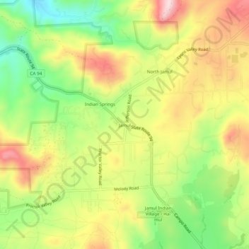
Name: Jamul topographic map, elevation, terrain.
Location: Jamul, California, 91935, United States (32.69700 -116.89613 32.73700 -116.85613)
Average elevation: 1,004 ft
Minimum elevation: 499 ft
Maximum elevation: 1,535 ft
California trails, hiking, mountain biking, running and outdoor activities
Other topographic maps
Click on a map to view its topography, its elevation and its terrain.
Big Bear Lake
United States > California > San Bernardino County > Big Bear Lake
At a surface elevation of 6,743 ft (2,055 m) above sea level, it has an east-west length of approximately seven miles (11 km) and is approximately 2.5 miles (4.0 km) at its widest measurement, though the lake's width mostly averages a little more than 1⁄2 mi (0.8 km). These approximations are based on the…
Average elevation: 7,247 ft
Palm Springs
United States > California > Riverside County
Palm Springs, located in the Coachella Valley, is characterized by striking topography shaped by both the Colorado Desert and surrounding mountain ranges. The city lies at an average elevation of around 480 feet (146 meters) above sea level. To the west, the San Bernardino Mountains rise dramatically, with…
Average elevation: 2,818 ft
Los Padres National Forest
Los Padres National Forest is a United States national forest in southern and central California. Administered by the United States Forest Service, Los Padres includes most of the mountainous land along the California coast from Ventura to Monterey, extending inland. Elevations range from sea level to 8,847…
Average elevation: 1,460 ft
Wofford Heights
United States > California > Kern County
Wofford Heights is a census-designated place (CDP) in the southern Sierra Nevada, in Kern County, California, United States. Wofford Heights is located in the west Kern River Valley, 3.5 miles (5.6 km) south-southwest of Kernville, at an elevation of 2,684 feet (818 m). The population was 2,200 at the 2010…
Average elevation: 3,655 ft
Bradley
United States > California > Monterey County
Bradley is an unincorporated community and census-designated place (CDP) in Monterey County, California, on the Salinas River 14 miles (23 km) south-southeast of San Ardo and 20 miles (32 km) north of Paso Robles. Bradley sits at an elevation of 548 feet (167 m). The population was 69 at the 2020 census, down…
Average elevation: 623 ft
Susanville
United States > California > Lassen County
Susanville (formerly known as Rooptown) is a town in and is the county seat of Lassen County, California, United States. Susanville is located on the Susan River in the southern part of the county, at an elevation of 4,186 feet (1,276 m). Its population is 16,728 as of the 2020 census, down from 17,947 from…
Average elevation: 4,413 ft
Hemet
United States > California > Hemet
Dedicated to James Simpson, Hemet City Council 1947–48, and mayor 1950 to 1966. Simpson Park is a wilderness park located in the Santa Rosa Hills southeast of Hemet with sheltered picnic area and tables, barbecues, restrooms, and hiking trails. At an elevation of 2,500 feet (760 m), it provides an expansive…
Average elevation: 1,667 ft
Quarry Lakes Regional Park
United States > California > Alameda County > Fremont > Eberly
Average elevation: 56 ft
Crystal Cove State Park
United States > California > Orange County > Newport Beach
Average elevation: 509 ft
King City
United States > California > Monterey County
King City (variants: Kings City, City of King) is a city in Monterey County, California, United States. It is located on the Salinas River 51 miles (82 km) southeast of Salinas, at an elevation of 335 feet (102 m). It lies along U.S. Route 101 in the Salinas Valley of California's Central Coast. King City is a…
Average elevation: 305 ft
Hollywood Hills
United States > California > Los Angeles County > Los Angeles
Average elevation: 794 ft
Yucca Valley
United States > California > San Bernardino County
Yucca Valley lies in the middle of the Morongo Basin at a base elevation of 3,300 feet. Joshua Tree National Park is adjacent to its southern border.
Average elevation: 3,629 ft
Bear Valley
United States > California > Alpine County
Bear Valley's central Sierra location and elevation gives it a warm-summer Mediterranean climate that is nearly a subarctic climate. Precipitation is seen for a lot of the year except for the middle of the summer, which can experience rare, but not unseen, thunderstorms. Late fall to early spring brings in…
Average elevation: 7,480 ft
Gilroy
United States > California > Gilroy
Gilroy is located at 37°00′43″N 121°34′48″W / 37.012048°N 121.580080°W / 37.012048; -121.580080. It is approximately 26 km (16 mi) south of San Jose, California (Bailey Avenue (37.206770, -121.729150) to Monterey/Day Road (37.038210, -121.584480)) on U.S. Route 101 and 31 km (19 mi) inland…
Average elevation: 348 ft
Sierra National Forest
Sierra National Forest covers, in descending order of forestland area, the eastern portions of Fresno, Madera, and Mariposa counties, adjacent to the southern part of Yosemite National Park. It includes more than 1,300,000 acres (2,000 sq mi; 5,300 km2), at altitudes ranging from 900 to 13,986 feet (274 to…
Average elevation: 6,519 ft
Pine Valley
According to the United States Geological Survey, Pine Valley is located 3,736 feet (1,139 m) above sea level, at 32°49′17″N 116°31′45″W / 32.82139°N 116.52917°W / 32.82139; -116.52917. Interstate 8 passes east-to-west along the southern border of Pine Valley. It crosses the Pine Valley…
Average elevation: 4,236 ft
Mojave National Preserve
Climate in the preserve varies greatly. Summer temperatures average 90 °F (32 °C), with highs exceeding 105 °F (41 °C). Elevations in the preserve range from 7,929 feet (2,417 m) at Clark Mountain to 880 feet (270 m) near Baker. Annual precipitation varies from 3.37 inches (86 mm) near Baker, to almost 9…
Average elevation: 3,146 ft
Lassen National Forest
An ancient volcano, known as Mount Tehama is believed to have been much larger and taller than Lassen Peak. Its erosion is responsible for the topography of the national forest and the national park: a volcanic rim, with elevations beginning at 6,000 feet (1,800 m) above sea level.
Average elevation: 4,895 ft
Anza-Borrego Desert State Park
Anza-Borrego Desert State Park lies in a unique geologic setting along the western margin of the Salton Trough. This major topographic depression with the Salton Sink having elevations of 200 ft (61 m) below sea level, forms the northernmost end of an active rift valley and a geological continental plate…
Average elevation: 1,988 ft
Independence
Independence is a census-designated place in Inyo County, California. Independence is located 41 miles (66 km) south-southeast of Bishop, at an elevation of 3930 feet (1198 m). It is the county seat of Inyo County, California. The population of this census-designated place was 669 at the 2010 census, up from…
Average elevation: 3,934 ft
Kern River
Despite its remote source, nearly all of the river is publicly accessible. The Kern River is particularly popular for wilderness hiking and whitewater rafting. The Upper Kern River is paralleled by trails to within a half-mile of its source (which lies at 13,600 feet (4,100 m)). Even with the presence of Lake…
Average elevation: 3,990 ft
Sierra Vista Open Space Preserve
United States > California > Santa Clara County > San Jose
Average elevation: 1,588 ft
Lodi
United States > California > San Joaquin County
Lodi is flat terrain at an elevation of approximately 50 feet (15 m) above mean sea level datum. Historically, land in the area has been used for grazing as well as for grain production.
Average elevation: 10 ft
Crescent City
United States > California > Del Norte County
The topography of the sea floor surrounding Crescent City has the effect of focusing tsunamis. According to researchers at Humboldt State University and the University of Southern California, the city experienced tsunami conditions 31 times between the years 1933 and 2008. Although many of these incidents were…
Average elevation: 102 ft
Lancaster
United States > California > Lancaster
According to the United States Census Bureau, the city has a total area of 94.5 square miles (245 km2), of which 94.3 square miles (244 km2) is land and 0.3 square miles (0.78 km2) (0.29%) is water. Lancaster's elevation is 2,350 feet (720 m) above sea level on a high, flat valley surrounded by pristine…
Average elevation: 2,582 ft
Idyllwild-Pine Cove
United States > California > Riverside County
"Mile-high Idyllwild" is a mountain resort about one-mile (1,600 m) in altitude. Idyllwild is flanked by two large rock formations, Tahquitz Peak and Suicide Rock (also known as Lily Rock), which are famous in Southern California rock-climbing circles. It offers no skiing, so "the Hill" has been minimally…
Average elevation: 5,728 ft
Twentynine Palms
United States > California > Twentynine Palms
According to the United States Census Bureau, the city has a total area of 59.1 square miles (153 km2), all land. The city is at an elevation of 1,988 feet (606 m). The Marine Corps Air Ground Combat Center Twentynine Palms is located there.
Average elevation: 2,264 ft
Pacific Palisades
United States > California > Los Angeles County > Los Angeles
Pacific Palisades was formally founded in 1921 by a Methodist organization, and in the years that followed became a refuge for Jewish artists and intellectuals fleeing the Holocaust. The Palisades would later be sought after by celebrities and other high-profile individuals seeking privacy. It is known for its…
Average elevation: 643 ft
Sebastopol
United States > California > Sonoma County
Sebastopol's elevation is 65 to 250 feet (20 to 76 meters) above sea level. Its downtown is at the intersection of State Route 12 and State Route 116 (Gravenstein Highway), approximately 9 mi (14 km) west of U.S. Route 101.
Average elevation: 226 ft
Shoshone
United States > California > CAL Fire San Bernardino Unit
According to the United States Census Bureau, the CDP has a total area of 28.7 square miles (74 km2), over 99% of it land. It is 14 miles (23 km) east of Epaulet Peak, at an elevation of 1585 feet (483 m).
Average elevation: 1,916 ft
Oakdale
United States > California > Stanislaus County
Historically the area has been used for orchards and other agricultural uses. Some of the common soil types found in Oakdale are Delhi sand, Oakdale sandy loam, Hanford sandy loam, and Tujunga loamy sand. Oakdale is generally on level ground at an elevation of approximately 190 feet (58 m) above mean sea…
Average elevation: 171 ft
The Forest of Nisene Marks State Park
United States > California > Santa Cruz County > Day Valley
Average elevation: 778 ft
Coachella
United States > California > Riverside County
The elevation is 68 feet (21 m) below sea level, as the eastern half of the Coachella Valley is below sea level. The saltwater lake, Salton Sea, 10 miles (16 km) south of Coachella, is 228 feet (69 m) below sea level.
Average elevation: -7 ft
Thousand Oaks
United States > California > Ventura County > Thousand Oaks
The northern parts consist of mountainous terrain in the Simi Hills, Conejo Mountains and Mount Clef Ridge. Narrow canyons such as Hill Canyon cut through the steeper mountainous areas. Conejo Mountain and Conejo Grade are found in westernmost Newbury Park, while the southernmost parts of Thousand Oaks are…
Average elevation: 994 ft
Mammoth Lakes
United States > California > Mammoth Lakes
Mammoth Lakes is a town in Mono County, California, the county's only incorporated community. It is located immediately to the east of Mammoth Mountain, at an elevation of 7,880 feet (2,400 m). As of the 2010 United States Census, the population was 8,234, reflecting a 16% increase from the 2000 Census.
Average elevation: 7,165 ft
Bermuda Dunes
United States > California > Riverside County > Palm Desert
According to the United States Census Bureau, the CDP has a total area of 2.9 square miles (7.5 km2), all of it land. The official elevation of Bermuda Dunes is 30 feet (9.1 m) above sea level, but the surface drops by over 80 feet (24 m) from west to east.
Average elevation: 89 ft
Fort Bragg
United States > California > Mendocino County
Fort Bragg, officially the City of Fort Bragg, is a city along the Pacific Coast of California along Shoreline Highway in Mendocino County. The city is 24 miles (39 km) west of Willits, at an elevation of 85 feet (26 m). Its population was 6,983 at the 2020 census.
Average elevation: 26 ft
Palm Desert
United States > California > Riverside County
The elevation (City hall) is 224 feet (68 m) above sea level. Elevations vary from the lower northern half once covered in sand dunes to the upper slope southern cove (300–900 feet or 91–274 metres) all the way to the ridgeline at 1,000 feet (over 300 meters). Palm Desert is located in the Coachella…
Average elevation: 978 ft
Corte Madera
United States > California > Marin County
Corte Madera (/ˈkɔːrtə məˈdɛrə/; Spanish for "Chop Wood") is an incorporated town in Marin County, California. Corte Madera is located 3.25 miles (5.2 km) south of San Rafael, at an elevation of 39 feet (12 m). The population was 10,222 at the 2020 census. The town was named after the Spanish…
Average elevation: 171 ft
Lakeport
United States > California > Lake County
Lakeport is an incorporated city and the county seat of Lake County, California. This city is 125 miles (201 km) northwest of Sacramento. Lakeport is on the western shore of the county namesake, Clear Lake, at an elevation of 1,355 feet (413 m). The population was 5,026 at the 2020 census, up from 4,753 at the…
Average elevation: 1,368 ft
Tranquillity
United States > California > Fresno County
Tranquillity is a census-designated place (CDP) in Fresno County, California, United States. It is located 10 miles (16 km) southeast of Mendota, at an elevation of 164 feet (50 m). The population was 799 at the 2010 census, down from 813 at the 2000 census. Tranquillity High School is the only high school in…
Average elevation: 161 ft