
Independence topographic map
Click on the map to display elevation.
Independence
Independence is a census-designated place in Inyo County, California. Independence is located 41 miles (66 km) south-southeast of Bishop, at an elevation of 3930 feet (1198 m). It is the county seat of Inyo County, California. The population of this census-designated place was 669 at the 2010 census, up from 574 at the 2000 census.
About this map
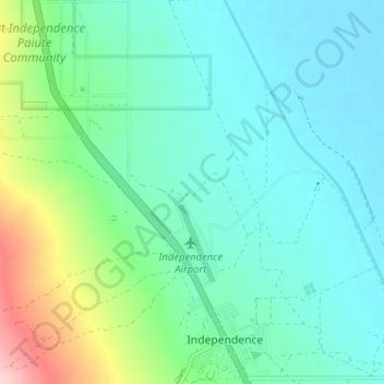
Name: Independence topographic map, elevation, terrain.
Location: Independence, Inyo County, California, United States (36.79653 -118.24719 36.84800 -118.18591)
Average elevation: 3,934 ft
Minimum elevation: 3,773 ft
Maximum elevation: 4,501 ft
California trails, hiking, mountain biking, running and outdoor activities
Other topographic maps
Click on a map to view its topography, its elevation and its terrain.
Big Bear Lake
United States > California > San Bernardino County > Big Bear Lake
At a surface elevation of 6,743 ft (2,055 m) above sea level, it has an east-west length of approximately seven miles (11 km) and is approximately 2.5 miles (4.0 km) at its widest measurement, though the lake's width mostly averages a little more than 1⁄2 mi (0.8 km). These approximations are based on the…
Average elevation: 7,247 ft
Palm Springs
United States > California > Riverside County
Palm Springs, located in the Coachella Valley, is characterized by striking topography shaped by both the Colorado Desert and surrounding mountain ranges. The city lies at an average elevation of around 480 feet (146 meters) above sea level. To the west, the San Bernardino Mountains rise dramatically, with…
Average elevation: 2,818 ft
Los Padres National Forest
Los Padres National Forest is a United States national forest in southern and central California. Administered by the United States Forest Service, Los Padres includes most of the mountainous land along the California coast from Ventura to Monterey, extending inland. Elevations range from sea level to 8,847…
Average elevation: 1,460 ft
Mono Lake
United States > California > Mono County
Lake Russell was the prehistoric predecessor to Mono Lake, during the Pleistocene. Its shoreline reached the modern-day elevation of 7,480 feet (2,280 m), about 1,100 feet (330 m) higher than the present-day lake. As of 1.6 million years ago, Lake Russell discharged to the northeast, into the Walker River…
Average elevation: 6,588 ft
Newbury Park
United States > California > Ventura County > Thousand Oaks
Newbury Park can be described as a town,[6] community,[94] or section[9] mostly within the Thousand Oaks city limits in addition to rural areas west of Thousand Oaks. Newbury Park is bordered by Lynn Road in the east and the Conejo Grade on the west. It borders the Santa Monica Mountains in the south, while…
Average elevation: 860 ft
Monmouth
United States > California > Fresno County
Monmouth is a census-designated place in Fresno County, California. It is located 7.25 miles (12 km) west of Selma, at an elevation of 276 feet (84 m). At the 2010 census, Monmouth had a population of 152.
Average elevation: 276 ft
Mariposa
United States > California > Mariposa County
Mariposa is located at 37°29′06″N 119°57′59″W / 37.48500°N 119.96639°W / 37.48500; -119.96639, at 1,949 feet (594 m) in elevation. It lies in the rugged foothills of the Sierra Nevada. Mariposa Creek flows through the town. Soils in the urban area are mostly brown to reddish brown loam of…
Average elevation: 2,257 ft
La Jolla
United States > California > San Diego County > San Diego > La Jolla
Average elevation: 121 ft
Santa Clarita
United States > California > Los Angeles County > Santa Clarita
Average elevation: 1,722 ft
Sierra National Forest
Sierra National Forest covers, in descending order of forestland area, the eastern portions of Fresno, Madera, and Mariposa counties, adjacent to the southern part of Yosemite National Park. It includes more than 1,300,000 acres (2,000 sq mi; 5,300 km2), at altitudes ranging from 900 to 13,986 feet (274 to…
Average elevation: 6,519 ft
Pine Valley
According to the United States Geological Survey, Pine Valley is located 3,736 feet (1,139 m) above sea level, at 32°49′17″N 116°31′45″W / 32.82139°N 116.52917°W / 32.82139; -116.52917. Interstate 8 passes east-to-west along the southern border of Pine Valley. It crosses the Pine Valley…
Average elevation: 4,236 ft
Mojave National Preserve
Climate in the preserve varies greatly. Summer temperatures average 90 °F (32 °C), with highs exceeding 105 °F (41 °C). Elevations in the preserve range from 7,929 feet (2,417 m) at Clark Mountain to 880 feet (270 m) near Baker. Annual precipitation varies from 3.37 inches (86 mm) near Baker, to almost 9…
Average elevation: 3,146 ft
Lassen National Forest
An ancient volcano, known as Mount Tehama is believed to have been much larger and taller than Lassen Peak. Its erosion is responsible for the topography of the national forest and the national park: a volcanic rim, with elevations beginning at 6,000 feet (1,800 m) above sea level.
Average elevation: 4,895 ft
Anza-Borrego Desert State Park
Anza-Borrego Desert State Park lies in a unique geologic setting along the western margin of the Salton Trough. This major topographic depression with the Salton Sink having elevations of 200 ft (61 m) below sea level, forms the northernmost end of an active rift valley and a geological continental plate…
Average elevation: 1,988 ft
Hollywood Hills
United States > California > Los Angeles County > Los Angeles
Average elevation: 794 ft
Pollock Pines
United States > California > El Dorado County
Pollock Pines is a census-designated place (CDP) in El Dorado County, California, United States. It is part of the Sacramento–Arden-Arcade–Roseville Metropolitan Statistical Area. Pollock Pines lies at an elevation of 3,980 feet (1,210 m) in the Sierra Nevada. The population was 6,871 at the 2010 census,…
Average elevation: 3,681 ft
Kern River
Despite its remote source, nearly all of the river is publicly accessible. The Kern River is particularly popular for wilderness hiking and whitewater rafting. The Upper Kern River is paralleled by trails to within a half-mile of its source (which lies at 13,600 feet (4,100 m)). Even with the presence of Lake…
Average elevation: 3,990 ft
Glacier Point
United States > California > Mariposa County > Curry Village
Glacier Point is a viewpoint above Yosemite Valley in the U.S. state of California. It is located on the south wall of Yosemite Valley at an elevation of 7,214 feet (2,199 m), 3,200 feet (980 m) above Curry Village. The point offers a superb view of several of Yosemite National Park's well-known landmarks,…
Average elevation: 5,823 ft
Calaveras Big Trees State Park
United States > California > Calaveras County
Average elevation: 4,511 ft
Rancho Santa Fe
The climate of Rancho Santa Fe is, for the most part, typical of the San Diego metropolitan area though its higher elevation and inland location lends itself to larger temperature variations.
Average elevation: 203 ft
Morgan Hill
United States > California > Santa Clara County > Morgan Hill
Morgan Hill is approximately 39 km (24 mi) south of downtown San Jose, 21 km (13 mi) north of Gilroy, and 24 km (15 mi) inland from the Pacific coast. Lying in a roughly 6 km-wide (4-mi-wide) southern extension of the Santa Clara Valley, it is bounded by the Santa Cruz Mountains to the west and the Diablo…
Average elevation: 476 ft
Menifee
United States > California > Riverside County
Menifee is a city in Riverside County, California, United States, and part of the Los Angeles Combined Statistical Area. The city is centrally located in Southern California in the Menifee Valley. It is almost 15 miles (24 km) north of Temecula and just north of Murrieta. Menifee is roughly 46 square miles…
Average elevation: 1,496 ft
Hidden Meadows
United States > California > San Diego County > Hidden Meadows
Average elevation: 1,175 ft
General Sherman Tree
United States > California > Tulare County
General Sherman is a giant sequoia (Sequoiadendron giganteum) tree located at an elevation of 2,109 m (6,919 ft) above sea level in the Giant Forest of Sequoia National Park in Tulare County, in the U.S. state of California. By volume, it is the largest known living single-stem tree on Earth.
Average elevation: 6,936 ft
San Luis Obispo
United States > California > San Luis Obispo County > San Luis Obispo
Average elevation: 833 ft
Arroyo Grande
United States > California > San Luis Obispo County > Arroyo Grande > Arroyo Grande
Average elevation: 184 ft
June Lake
United States > California > Mono County
June Lake is an unincorporated community and census-designated place (CDP) in Mono County, California, United States. It is located against the southern rim of the Mono Basin, 12.5 miles (20 km) south of Lee Vining, at an elevation of 7,654 feet (2,333 m).
Average elevation: 8,360 ft
Laytonville
United States > California > Mendocino County
Laytonville is a census-designated place (CDP) in Mendocino County, California, United States. It is located 23 miles (37 km) north-northwest of Willits, at an elevation of 1,670 feet (510 m). The population was 1,152 at the 2020 census, down from 1,227 at the 2010 census.
Average elevation: 1,949 ft