
Make a donation
Gear up for your next adventure:
As an Amazon Associate, this site earns from qualifying purchases at no extra cost to you.
Glenfield topographic map
Click on the map to display elevation.
Make a donation
Gear up for your next adventure:
As an Amazon Associate, this site earns from qualifying purchases at no extra cost to you.
About this map
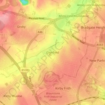
Name: Glenfield topographic map, elevation, terrain.
Average elevation: 289 ft
Minimum elevation: 59 ft
Maximum elevation: 394 ft
Make a donation
Gear up for your next adventure:
As an Amazon Associate, this site earns from qualifying purchases at no extra cost to you.
Other topographic maps
Click on a map to view its topography, its elevation and its terrain.
Stoke Golding
United Kingdom > England > Leicestershire > Hinckley and Bosworth
Average elevation: 335 ft
Make a donation
Gear up for your next adventure:
As an Amazon Associate, this site earns from qualifying purchases at no extra cost to you.
Kelham Bridge Nature Reserve
United Kingdom > England > Leicestershire > North West Leicestershire > Ravenstone
Average elevation: 456 ft
Market Bosworth Country Park
United Kingdom > England > Leicestershire > Hinckley and Bosworth > Market Bosworth
Average elevation: 390 ft
Make a donation
Gear up for your next adventure:
As an Amazon Associate, this site earns from qualifying purchases at no extra cost to you.
Watermead Country Park
United Kingdom > England > Leicestershire > Charnwood > Birstall
Average elevation: 194 ft
Markfield
United Kingdom > England > Leicestershire > Hinckley and Bosworth > Markfield
Average elevation: 571 ft
Castle Donington
United Kingdom > England > Leicestershire > North West Leicestershire > Hemington
Average elevation: 184 ft
Make a donation
Gear up for your next adventure:
As an Amazon Associate, this site earns from qualifying purchases at no extra cost to you.
Bottesford
United Kingdom > England > Leicestershire > Melton
Bottesford's many listed buildings include the grade I listed 13th-century Church of St Mary the Virgin. There are two scheduled monuments within the village – Fleming's Bridge and the stone cross in the Market Place. The stocks and whipping post are Grade II listed. One of the Grade II listed buildings,…
Average elevation: 128 ft
Make a donation
Gear up for your next adventure:
As an Amazon Associate, this site earns from qualifying purchases at no extra cost to you.
South Croxton
United Kingdom > England > Leicestershire > Charnwood > South Croxton
The highest point is the church, at 120 m above mean sea level. The lowest altitude is 85 m by the Queniborough Brook.
Average elevation: 354 ft
Brocks Hill
United Kingdom > England > Leicestershire > Oadby and Wigston > Oadby
Average elevation: 335 ft
Groby
United Kingdom > England > Leicestershire > Hinckley and Bosworth > Groby
Average elevation: 351 ft
Adrian's Spinney
United Kingdom > England > Leicestershire > Harborough > Stoughton
Average elevation: 371 ft
Make a donation
Gear up for your next adventure:
As an Amazon Associate, this site earns from qualifying purchases at no extra cost to you.
Swannington
United Kingdom > England > Leicestershire > North West Leicestershire > Coalville
Average elevation: 433 ft
Stoughton
United Kingdom > England > Leicestershire > Harborough > Stoughton
Average elevation: 400 ft
Ashby-de-la-Zouch
United Kingdom > England > Leicestershire > North West Leicestershire
Average elevation: 433 ft
Queniborough
United Kingdom > England > Leicestershire > Charnwood > Queniborough
Average elevation: 246 ft
Make a donation
Gear up for your next adventure:
As an Amazon Associate, this site earns from qualifying purchases at no extra cost to you.
Illston on the Hill
United Kingdom > England > Leicestershire > Harborough > Illston on the Hill
Average elevation: 518 ft
Make a donation
Gear up for your next adventure:
As an Amazon Associate, this site earns from qualifying purchases at no extra cost to you.
Gilmorton
United Kingdom > England > Leicestershire > Harborough > Gilmorton
Average elevation: 446 ft
Make a donation
Gear up for your next adventure:
As an Amazon Associate, this site earns from qualifying purchases at no extra cost to you.
Langham Brook
United Kingdom > England > Leicestershire > Melton > Saxby > Freeby
Average elevation: 308 ft
Great Glen
United Kingdom > England > Leicestershire > Harborough > Great Glen
Average elevation: 377 ft
Buckminster
United Kingdom > England > Leicestershire > Melton > Buckminster
Average elevation: 443 ft
Lount Wood
United Kingdom > England > Leicestershire > North West Leicestershire > Lount
Average elevation: 430 ft
Make a donation
Gear up for your next adventure:
As an Amazon Associate, this site earns from qualifying purchases at no extra cost to you.
Leicester Forest East
United Kingdom > England > Leicestershire > Leicester Forest East
Average elevation: 315 ft
South Kilworth
United Kingdom > England > Leicestershire > Harborough > South Kilworth
Average elevation: 440 ft
Make a donation
Gear up for your next adventure:
As an Amazon Associate, this site earns from qualifying purchases at no extra cost to you.
Leicestershire
United Kingdom > England > Leicestershire
A large part of the north-west of the county, around Coalville, forms part of the new National Forest area extending into Derbyshire and Staffordshire. The highest point of the county is Bardon Hill at 278 m (912 ft), which is also a Marilyn; with other hilly/upland areas of c. 150–200 metres (490–660 ft)…
Average elevation: 322 ft
Ibstock
United Kingdom > England > Leicestershire > North West Leicestershire
Average elevation: 440 ft
Whitwick
United Kingdom > England > Leicestershire > North West Leicestershire
Average elevation: 499 ft
Bradgate Park
United Kingdom > England > Leicestershire > Charnwood > Newtown Linford
Overlying the Beacon Hill Formation, but found a little further down the hillside to the south, are the Bradgate Formation beds, the most notable of which is the Sliding Stone Slump Breccia rocks. Forming a line of crags below Old John, these are laminated mudstones, with layers of sandstone, mainly of…
Average elevation: 413 ft
Make a donation
Gear up for your next adventure:
As an Amazon Associate, this site earns from qualifying purchases at no extra cost to you.
Broughton Astley
United Kingdom > England > Leicestershire > Harborough > Broughton Astley
Average elevation: 285 ft
Nailstone Colliery Railway
United Kingdom > England > Leicestershire > North West Leicestershire > Ibstock
Average elevation: 509 ft
Make a donation
Gear up for your next adventure:
As an Amazon Associate, this site earns from qualifying purchases at no extra cost to you.
Breedon Cloud Wood
United Kingdom > England > Leicestershire > North West Leicestershire > Breedon on the Hill
Average elevation: 295 ft
Mountsorrel
United Kingdom > England > Leicestershire > Charnwood > Mountsorrel
Average elevation: 187 ft
Swannymote Rock
United Kingdom > England > Leicestershire > North West Leicestershire > Coalville
Average elevation: 456 ft
Make a donation
Gear up for your next adventure:
As an Amazon Associate, this site earns from qualifying purchases at no extra cost to you.
Thornton Reservoir
United Kingdom > England > Leicestershire > Hinckley and Bosworth > Thornton
Average elevation: 456 ft
Willesley Woods
United Kingdom > England > Leicestershire > North West Leicestershire > Ashby-de-la-Zouch > Willesley
Average elevation: 354 ft
Earl Shilton
United Kingdom > England > Leicestershire > Hinckley and Bosworth
Average elevation: 331 ft
Moat Hill Spinney
United Kingdom > England > Leicestershire > Charnwood > Cotes
Average elevation: 164 ft
Make a donation
Gear up for your next adventure:
As an Amazon Associate, this site earns from qualifying purchases at no extra cost to you.
Belvoir Castle
United Kingdom > England > Leicestershire > Melton > Belvoir
The traditional burial place of the Manners family was St Mary the Virgin's Church, Bottesford. Since elevation to the dukedom in 1703 most Dukes have been buried in the grounds of the mausoleum at Belvoir Castle. The mausoleum at Belvoir Castle was built by The 5th Duke of Rutland, following the death of his…
Average elevation: 269 ft
Lea Wood
United Kingdom > England > Leicestershire > Charnwood > Newtown Linford
Average elevation: 558 ft
Make a donation
Gear up for your next adventure:
As an Amazon Associate, this site earns from qualifying purchases at no extra cost to you.
Charnwood Water
United Kingdom > England > Leicestershire > Charnwood > Woodthorpe
Average elevation: 154 ft
Make a donation
Gear up for your next adventure:
As an Amazon Associate, this site earns from qualifying purchases at no extra cost to you.
Osgathorpe
United Kingdom > England > Leicestershire > North West Leicestershire
Average elevation: 315 ft
Thurmaston
United Kingdom > England > Leicestershire > Charnwood > Thurmaston
Average elevation: 203 ft
Normanton Le Heath
United Kingdom > England > Leicestershire > North West Leicestershire
Average elevation: 404 ft
Make a donation
Gear up for your next adventure:
As an Amazon Associate, this site earns from qualifying purchases at no extra cost to you.
Make a donation
Gear up for your next adventure:
As an Amazon Associate, this site earns from qualifying purchases at no extra cost to you.
Croxton Kerrial
United Kingdom > England > Leicestershire > Melton > Croxton Kerrial
Average elevation: 420 ft
Make a donation
Gear up for your next adventure:
As an Amazon Associate, this site earns from qualifying purchases at no extra cost to you.
Kegworth
United Kingdom > England > Leicestershire > North West Leicestershire > Kegworth
Average elevation: 161 ft
Make a donation
Gear up for your next adventure:
As an Amazon Associate, this site earns from qualifying purchases at no extra cost to you.
Kimcote and Walton
United Kingdom > England > Leicestershire > Harborough > Kimcote and Walton
Average elevation: 472 ft
Saddington
United Kingdom > England > Leicestershire > Harborough > Saddington
Average elevation: 417 ft
Make a donation
Gear up for your next adventure:
As an Amazon Associate, this site earns from qualifying purchases at no extra cost to you.
Packington
United Kingdom > England > Leicestershire > North West Leicestershire
Average elevation: 390 ft
Ratcliffe on the Wreake
United Kingdom > England > Leicestershire > Charnwood
Average elevation: 226 ft
Little Stretton
United Kingdom > England > Leicestershire > Harborough > Little Stretton
Average elevation: 433 ft
Make a donation
Gear up for your next adventure:
As an Amazon Associate, this site earns from qualifying purchases at no extra cost to you.
Make a donation
Gear up for your next adventure:
As an Amazon Associate, this site earns from qualifying purchases at no extra cost to you.
Make a donation
Gear up for your next adventure:
As an Amazon Associate, this site earns from qualifying purchases at no extra cost to you.
Coleorton
United Kingdom > England > Leicestershire > North West Leicestershire
Average elevation: 427 ft
Make a donation
Gear up for your next adventure:
As an Amazon Associate, this site earns from qualifying purchases at no extra cost to you.