
Lichfield topographic map
Click on the map to display elevation.
About this map
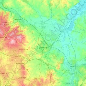
Name: Lichfield topographic map, elevation, terrain.
Location: Lichfield, Staffordshire, England, United Kingdom (52.58489 -1.96323 52.80779 -1.58629)
Average elevation: 338 ft
Minimum elevation: 141 ft
Maximum elevation: 791 ft
Other topographic maps
Click on a map to view its topography, its elevation and its terrain.
Rudyard Lake
United Kingdom > England > Staffordshire > Staffordshire Moorlands > Rudyard > Horton
Average elevation: 673 ft
College Gardens
United Kingdom > England > Staffordshire > Newcastle-under-Lyme > Madeley
Average elevation: 404 ft
Tutbury Castle
United Kingdom > England > Staffordshire > East Staffordshire > Tutbury
Average elevation: 217 ft
Burton upon Trent
United Kingdom > England > Staffordshire > East Staffordshire
Burton is about 109 miles (175 km) north west of London, about 30 miles north east of Birmingham, the UK's second largest city and about 23 miles east of the county town Stafford. It is at the easternmost border of the county of Staffordshire with Derbyshire, its suburbs and the course of the River Trent…
Average elevation: 226 ft
Werrington
United Kingdom > England > Staffordshire > Staffordshire Moorlands
Average elevation: 751 ft
Stubwood
United Kingdom > England > Staffordshire > East Staffordshire > Denstone
Average elevation: 371 ft
Birch Cross
United Kingdom > England > Staffordshire > East Staffordshire > Marchington
Average elevation: 302 ft
Biddulph Moor
United Kingdom > England > Staffordshire > Staffordshire Moorlands
Average elevation: 794 ft
Wain Lea
United Kingdom > England > Staffordshire > Newcastle-under-Lyme > Harriseahead
Average elevation: 679 ft
Fauld
United Kingdom > England > Staffordshire > East Staffordshire > Hanbury
Average elevation: 289 ft
Weston Park
United Kingdom > England > Staffordshire > South Staffordshire > Weston under Lizard
Average elevation: 371 ft
Stepping Stones
United Kingdom > England > Staffordshire > Staffordshire Moorlands
Average elevation: 735 ft
Bottomhouse
United Kingdom > England > Staffordshire > Staffordshire Moorlands > Ipstones
Average elevation: 1,024 ft
Apedale
United Kingdom > England > Staffordshire > Newcastle-under-Lyme > Chesterton
Average elevation: 551 ft
Levedale
United Kingdom > England > Staffordshire > South Staffordshire > Penkridge
Average elevation: 322 ft
Roughcote
United Kingdom > England > Staffordshire > Staffordshire Moorlands > Caverswall
Average elevation: 712 ft
Blackshaw Moor
United Kingdom > England > Staffordshire > Staffordshire Moorlands > Thorncliffe
Average elevation: 925 ft
Castle Ring
United Kingdom > England > Staffordshire > Cannock Chase > Cannock Wood
It is the highest point on The Chase with an elevation of 242 metres (794 ft).
Average elevation: 627 ft
Himley
United Kingdom > England > Staffordshire > South Staffordshire > Himley
Average elevation: 315 ft
Newcastle-under-Lyme
United Kingdom > England > Staffordshire > Newcastle-under-Lyme
Average elevation: 482 ft
Bignall End
United Kingdom > England > Staffordshire > Newcastle-under-Lyme > Audley
Average elevation: 492 ft
Bednall
United Kingdom > England > Staffordshire > South Staffordshire > Bednall
Average elevation: 387 ft
Halfpenny Green
United Kingdom > England > Staffordshire > South Staffordshire
Average elevation: 299 ft
Blithfield Reservoir
United Kingdom > England > Staffordshire > East Staffordshire > Admaston
Average elevation: 354 ft
Lower Lee
United Kingdom > England > Staffordshire > Staffordshire Moorlands > Meerbrook > Lower Lee
Average elevation: 866 ft
Betley Mere
United Kingdom > England > Staffordshire > Borough of Newcastle-under-Lyme > Wrinehill > Cracow Moss
Average elevation: 266 ft
Ashley Heath
United Kingdom > England > Staffordshire > Newcastle-under-Lyme
Average elevation: 630 ft
Horton
United Kingdom > England > Staffordshire > Staffordshire Moorlands > Gratton
Average elevation: 653 ft
Acton Trussell
United Kingdom > England > Staffordshire > South Staffordshire
Average elevation: 305 ft
Merryton Low
United Kingdom > England > Staffordshire > Staffordshire Moorlands
Average elevation: 1,352 ft
Wood Lane
United Kingdom > England > Staffordshire > Newcastle-under-Lyme > Bignall Hill
Average elevation: 551 ft
Rushton Spencer
United Kingdom > England > Staffordshire > Staffordshire Moorlands
Average elevation: 669 ft
Calf Heath
United Kingdom > England > Staffordshire > South Staffordshire > Hatherton Junction
Average elevation: 371 ft
Chasewater
United Kingdom > England > Staffordshire > Lichfield > Burntwood > Chasetown
Average elevation: 509 ft
Wetley Rocks
United Kingdom > England > Staffordshire > Staffordshire Moorlands
Average elevation: 751 ft
Old Hannah's Hole
United Kingdom > England > Staffordshire > Staffordshire Moorlands > Wetton
Average elevation: 906 ft
Milk Hill
United Kingdom > England > Staffordshire > Staffordshire Moorlands
Average elevation: 899 ft
Moneystone
United Kingdom > England > Staffordshire > Staffordshire Moorlands > Cotton
Average elevation: 758 ft
Biddulph Grange Country Park
United Kingdom > England > Staffordshire > Staffordshire Moorlands > Biddulph > Biddulph Moor
Average elevation: 751 ft
Moneystone Quarry
United Kingdom > England > Staffordshire > Staffordshire Moorlands > Kingsley > Whiston Eaves
Average elevation: 663 ft
Hales Hall Pool
United Kingdom > England > Staffordshire > Staffordshire Moorlands > Cheadle
Average elevation: 597 ft
Mottey Meadows NNR
United Kingdom > England > Staffordshire > South Staffordshire > Wheaton Aston
Average elevation: 361 ft
Brown Edge
United Kingdom > England > Staffordshire > Staffordshire Moorlands
Average elevation: 646 ft
Whiston
United Kingdom > England > Staffordshire > South Staffordshire > Penkridge
Average elevation: 312 ft
Cellarhead
United Kingdom > England > Staffordshire > Staffordshire Moorlands
Average elevation: 787 ft
Whitmore Heath
United Kingdom > England > Staffordshire > Newcastle-under-Lyme > Whitmore
Average elevation: 463 ft
Birks Wood
United Kingdom > England > Staffordshire > Newcastle-under-Lyme > Shraleybrook
Average elevation: 358 ft
Gratwich
United Kingdom > England > Staffordshire > East Staffordshire > Kingstone
Average elevation: 469 ft
Hope
United Kingdom > England > Staffordshire > Staffordshire Moorlands > Alstonefield
Average elevation: 899 ft
Burgess Brook
United Kingdom > England > Staffordshire > Newcastle-under-Lyme
Average elevation: 489 ft
Lutley
United Kingdom > England > Staffordshire > South Staffordshire > Enville
Average elevation: 328 ft