
Make a donation
Gear up for your next adventure:
As an Amazon Associate, this site earns from qualifying purchases at no extra cost to you.
Pljevlja Municipality topographic map
Click on the map to display elevation.
Make a donation
Gear up for your next adventure:
As an Amazon Associate, this site earns from qualifying purchases at no extra cost to you.
Pljevlja Municipality
The highest point of the municipality is on the Ljubišnja mountain at an altitude of 2,238 m (7,343 ft), while the lowest point is in the canyon of the Tara river with an altitude of 529 m (1,736 ft) above sea level. The municipality borders Žabljak Municipality, Bijelo Polje Municipality and Mojkovac Municipality in Montenegro, as well as the republics of Serbia and with Bosnia and Herzegovina. With a total area of 1,346 km2 (520 sq mi), it is the third largest municipality in Montenegro.
Make a donation
Gear up for your next adventure:
As an Amazon Associate, this site earns from qualifying purchases at no extra cost to you.
About this map
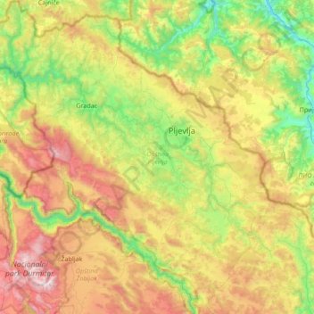
Name: Pljevlja Municipality topographic map, elevation, terrain.
Location: Pljevlja Municipality, 84210, Montenegro (43.06612 18.91244 43.55851 19.55128)
Average elevation: 3,786 ft
Minimum elevation: 1,296 ft
Maximum elevation: 8,071 ft
Make a donation
Gear up for your next adventure:
As an Amazon Associate, this site earns from qualifying purchases at no extra cost to you.
Other topographic maps
Click on a map to view its topography, its elevation and its terrain.
Make a donation
Gear up for your next adventure:
As an Amazon Associate, this site earns from qualifying purchases at no extra cost to you.
Kolašin
Montenegro > Kolašin Municipality
Kolašin is located on the foot of Bjelasica and Sinjajevina mountains, which offer great conditions for skiing. Because of Kolašin's altitude (954 m), the town is considered an air spa.
Average elevation: 3,717 ft
Make a donation
Gear up for your next adventure:
As an Amazon Associate, this site earns from qualifying purchases at no extra cost to you.
Make a donation
Gear up for your next adventure:
As an Amazon Associate, this site earns from qualifying purchases at no extra cost to you.