
Make a donation
Gear up for your next adventure:
As an Amazon Associate, this site earns from qualifying purchases at no extra cost to you.
Division No. 19 topographic map
Click on the map to display elevation.
Make a donation
Gear up for your next adventure:
As an Amazon Associate, this site earns from qualifying purchases at no extra cost to you.
About this map
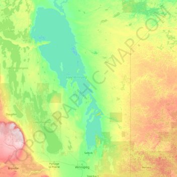
Name: Division No. 19 topographic map, elevation, terrain.
Location: Division No. 19, Manitoba, Canada (50.37091 -101.67168 53.30755 -94.40026)
Average elevation: 955 ft
Minimum elevation: 696 ft
Maximum elevation: 2,421 ft
Make a donation
Gear up for your next adventure:
As an Amazon Associate, this site earns from qualifying purchases at no extra cost to you.
Other topographic maps
Click on a map to view its topography, its elevation and its terrain.
Pinawa
Canada > Manitoba > Division No. 1 > Local Government District of Pinawa
Average elevation: 909 ft
Make a donation
Gear up for your next adventure:
As an Amazon Associate, this site earns from qualifying purchases at no extra cost to you.
Franklin
Canada > Manitoba > Division No. 15 > Rural Municipality of Rosedale
Average elevation: 1,598 ft
Make a donation
Gear up for your next adventure:
As an Amazon Associate, this site earns from qualifying purchases at no extra cost to you.
Arden
Canada > Manitoba > Division No. 8 > Municipality of Glenella – Lansdowne
Average elevation: 1,073 ft
Turtle Mountain Provincial Park
Canada > Manitoba > Municipality of Boissevain-Morton
Average elevation: 2,172 ft
Make a donation
Gear up for your next adventure:
As an Amazon Associate, this site earns from qualifying purchases at no extra cost to you.
Oak Bluff
Canada > Manitoba > Division No. 10 > Rural Municipality of Macdonald
Average elevation: 781 ft
Silverton
Canada > Manitoba > Division No. 16 > Rural Municipality of Riding Mountain West
Average elevation: 1,886 ft
Sunset Beach
Canada > Manitoba > Division No. 13 > Rural Municipality of St. Clements
Average elevation: 732 ft
Make a donation
Gear up for your next adventure:
As an Amazon Associate, this site earns from qualifying purchases at no extra cost to you.
Garson
Canada > Manitoba > Division No. 12 > Rural Municipality of Brokenhead
Average elevation: 794 ft
Make a donation
Gear up for your next adventure:
As an Amazon Associate, this site earns from qualifying purchases at no extra cost to you.
Ile des Chenes
Canada > Manitoba > Division No. 2 > Rural Municipality of Ritchot
Average elevation: 774 ft
Winnipeg
Canada > Manitoba > Winnipeg > Winnipeg
Winnipeg lies at the bottom of the Red River Valley, a flood plain with an extremely flat topography. It is on the eastern edge of the Canadian Prairies in Western Canada and is known as the "Gateway to the West". Winnipeg is bordered by tallgrass prairie to the west and south and the aspen parkland to the…
Average elevation: 774 ft
Make a donation
Gear up for your next adventure:
As an Amazon Associate, this site earns from qualifying purchases at no extra cost to you.
Darwin
Canada > Manitoba > Division No. 1 > Rural Municipality of Whitemouth
Average elevation: 961 ft
Make a donation
Gear up for your next adventure:
As an Amazon Associate, this site earns from qualifying purchases at no extra cost to you.
Oak Lake Beach
Canada > Manitoba > Division No. 6 > Rural Municipality of Sifton
Average elevation: 1,407 ft
Make a donation
Gear up for your next adventure:
As an Amazon Associate, this site earns from qualifying purchases at no extra cost to you.
Butler
Canada > Manitoba > Division No. 6 > Rural Municipality of Wallace – Woodworth
Average elevation: 1,719 ft
Lenore
Canada > Manitoba > Division No. 6 > Rural Municipality of Wallace – Woodworth
Average elevation: 1,509 ft