
Chaumox topographic map
Click on the map to display elevation.
About this map
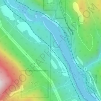
Name: Chaumox topographic map, elevation, terrain.
Average elevation: 1,030 ft
Minimum elevation: 322 ft
Maximum elevation: 3,025 ft
Other topographic maps
Click on a map to view its topography, its elevation and its terrain.
Chehalis Lake
Canada > British Columbia > Fraser Valley Regional District > Area C (Sasquatch Country)
Average elevation: 2,411 ft
Area A (Boston Bar/North Bend/Canyon Alpine)
Canada > British Columbia > Fraser Valley Regional District
Average elevation: 4,134 ft
Vedder River
Canada > British Columbia > Fraser Valley Regional District > Chilliwack
Average elevation: 361 ft
Mission
Canada > British Columbia > Fraser Valley Regional District
The western part of the district, the Stave Valley, is largely rural and forested but its watercourse is home to what was the largest hydroelectric project in British Columbia until the Bridge River Power Project opened in 1961. It was built by the British Columbia Electric Railway (BCER) to provide power to…
Average elevation: 1,132 ft
Chilliwack Lake
Canada > British Columbia > Fraser Valley Regional District > Area E (Chilliwack River Valley)
Average elevation: 3,780 ft
Cultus Lake
Canada > British Columbia > Fraser Valley Regional District > Area H (Cultus Lake/Columbia Valley) > Cultus Lake
Average elevation: 627 ft
Chehalis River
Canada > British Columbia > Fraser Valley Regional District > Area C (Sasquatch Country)
Average elevation: 1,391 ft
Area E (Chilliwack River Valley)
Canada > British Columbia > Fraser Valley Regional District
Average elevation: 3,386 ft
Harrison River
Canada > British Columbia > Fraser Valley Regional District > Kent > Harrison Mills
Average elevation: 148 ft
Sumas River
Canada > British Columbia > Fraser Valley Regional District > Abbotsford
Average elevation: 548 ft
Harrison Hot Springs
Canada > British Columbia > Fraser Valley Regional District
Average elevation: 666 ft
Harrison Lake
Canada > British Columbia > Fraser Valley Regional District > Area C (Sasquatch Country)
Average elevation: 2,674 ft
Stave Lake
Canada > British Columbia > Fraser Valley Regional District > Mission
Average elevation: 1,880 ft
Glacier Lake
Canada > British Columbia > Fraser Valley Regional District > Area C (Sasquatch Country)
Average elevation: 2,014 ft
Sloquet Creek
Canada > British Columbia > Fraser Valley Regional District > Area C (Sasquatch Country)
Average elevation: 837 ft
Campbell Lake
Canada > British Columbia > Fraser Valley Regional District > Kent
Average elevation: 1,732 ft
Area F (McConnell Creek/Hatzic Prairie)
Canada > British Columbia > Fraser Valley Regional District
Average elevation: 2,730 ft
Falls Lake
Canada > British Columbia > Fraser Valley Regional District > Area B (South Fraser Canyon/Sunshine Valley)
Average elevation: 4,961 ft
Jones Lake
Canada > British Columbia > Fraser Valley Regional District > Area D (Popkum/Bridal Falls/Wahleach)
Average elevation: 3,136 ft
Stoney Creek Park
Canada > British Columbia > Fraser Valley Regional District > Abbotsford
Average elevation: 131 ft
Hicks Lake
Canada > British Columbia > Fraser Valley Regional District > Kent
Average elevation: 1,237 ft
Area B (South Fraser Canyon/Sunshine Valley)
Canada > British Columbia > Fraser Valley Regional District
Average elevation: 3,852 ft
Area H (Cultus Lake/Columbia Valley)
Canada > British Columbia > Fraser Valley Regional District
Average elevation: 1,857 ft
Sumas Prairie
Canada > British Columbia > Fraser Valley Regional District > Abbotsford
Average elevation: 522 ft
Serpentine Lake
Canada > British Columbia > Fraser Valley Regional District > Area B (South Fraser Canyon/Sunshine Valley)
Average elevation: 3,150 ft
Isabel Lake
Canada > British Columbia > Fraser Valley Regional District > Area F (McConnell Creek/Hatzic Prairie)
Average elevation: 2,254 ft
Area C (Sasquatch Country)
Canada > British Columbia > Fraser Valley Regional District
Average elevation: 3,241 ft
Misty Icefield
Canada > British Columbia > Fraser Valley Regional District > Area F (McConnell Creek/Hatzic Prairie)
Average elevation: 5,906 ft
Mamquam Icefield
Canada > British Columbia > Fraser Valley Regional District > Area F (McConnell Creek/Hatzic Prairie)
Average elevation: 6,316 ft
Hope Slide
Canada > British Columbia > Fraser Valley Regional District > Area B (South Fraser Canyon/Sunshine Valley)
Average elevation: 3,806 ft
Area G (Deroche/Dewdney/Sumas Mountain)
Canada > British Columbia > Fraser Valley Regional District > Area G (Deroche/Dewdney/Sumas Mountain)
Average elevation: 692 ft
Area C (Sasquatch Country)
Canada > British Columbia > Fraser Valley Regional District
Average elevation: 3,241 ft
Mission
Canada > British Columbia > Fraser Valley Regional District
The western part of the district, the Stave Valley, is largely rural and forested but its watercourse is home to what was the largest hydroelectric project in British Columbia until the Bridge River Power Project opened in 1961. It was built by the British Columbia Electric Railway (BCER) to provide power to…
Average elevation: 1,132 ft
Sumas Prairie
Canada > British Columbia > Fraser Valley Regional District > Abbotsford
Average elevation: 522 ft
Area D (Popkum/Bridal Falls/Wahleach)
Canada > British Columbia > Fraser Valley Regional District
Average elevation: 3,110 ft
Area B (South Fraser Canyon/Sunshine Valley)
Canada > British Columbia > Fraser Valley Regional District
Average elevation: 3,852 ft
Mission
Canada > British Columbia > Fraser Valley Regional District
The western part of the district, the Stave Valley, is largely rural and forested but its watercourse is home to what was the largest hydroelectric project in British Columbia until the Bridge River Power Project opened in 1961. It was built by the British Columbia Electric Railway (BCER) to provide power to…
Average elevation: 1,132 ft
Turner Glacier
Canada > British Columbia > Fraser Valley Regional District > Area C (Sasquatch Country)
Average elevation: 7,162 ft
Ryder Lake
Canada > British Columbia > Fraser Valley Regional District > Chilliwack
Average elevation: 837 ft
Area D (Popkum/Bridal Falls/Wahleach)
Canada > British Columbia > Fraser Valley Regional District
Average elevation: 3,110 ft
Harrison-Chehalis Wildlife Management Area
Canada > British Columbia > Fraser Valley Regional District > Area C (Sasquatch Country) > Harrison Mills
Average elevation: 614 ft
Misty Icefield
Canada > British Columbia > Fraser Valley Regional District > Area F (McConnell Creek/Hatzic Prairie)
Average elevation: 5,906 ft
Area D (Popkum/Bridal Falls/Wahleach)
Canada > British Columbia > Fraser Valley Regional District
Average elevation: 3,110 ft
Mission
Canada > British Columbia > Fraser Valley Regional District
The western part of the district, the Stave Valley, is largely rural and forested but its watercourse is home to what was the largest hydroelectric project in British Columbia until the Bridge River Power Project opened in 1961. It was built by the British Columbia Electric Railway (BCER) to provide power to…
Average elevation: 1,132 ft
Harrison Hot Springs
Canada > British Columbia > Fraser Valley Regional District
Average elevation: 676 ft
Area B (South Fraser Canyon/Sunshine Valley)
Canada > British Columbia > Fraser Valley Regional District
Average elevation: 3,852 ft