
Abbotsford topographic map
Click on the map to display elevation.
About this map
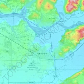
Name: Abbotsford topographic map, elevation, terrain.
Average elevation: 325 ft
Minimum elevation: -7 ft
Maximum elevation: 3,291 ft
Other topographic maps
Click on a map to view its topography, its elevation and its terrain.
Chehalis Lake
Canada > British Columbia > Fraser Valley Regional District > Area C (Sasquatch Country)
Average elevation: 2,411 ft
Cultus Lake
Canada > British Columbia > Fraser Valley Regional District > Area H (Cultus Lake/Columbia Valley) > Cultus Lake
Average elevation: 627 ft
Hope
Canada > British Columbia > Fraser Valley Regional District > Hope > Hope
Average elevation: 1,427 ft
Harrison River
Canada > British Columbia > Fraser Valley Regional District > Kent > Harrison Mills
Average elevation: 148 ft
Sumas River
Canada > British Columbia > Fraser Valley Regional District > Abbotsford
Average elevation: 548 ft
Pattinson Peak
Canada > British Columbia > Fraser Valley Regional District > Area F (McConnell Creek/Hatzic Prairie)
Average elevation: 2,500 ft
Sloquet Creek
Canada > British Columbia > Fraser Valley Regional District > Area C (Sasquatch Country)
Average elevation: 837 ft
Campbell Lake
Canada > British Columbia > Fraser Valley Regional District > Kent
Average elevation: 1,732 ft
Minto Landing
Canada > British Columbia > Fraser Valley Regional District > Chilliwack
Average elevation: 62 ft
Whippoorwill Point
Canada > British Columbia > Fraser Valley Regional District > Harrison Hot Springs
Average elevation: 377 ft
Mount Barr
Canada > British Columbia > Fraser Valley Regional District > Area D (Popkum/Bridal Falls/Wahleach)
Mount Barr is a mountain in the Skagit Range of the Cascade Mountains of southern British Columbia, Canada, located on the northeast side of Wahleach Lake and just southwest of Hope. It is a ridge highpoint with an elevation of 1,907 m (6,257 ft).
Average elevation: 4,639 ft
Lindell Beach
Canada > British Columbia > Fraser Valley Regional District > Area H (Cultus Lake/Columbia Valley)
Average elevation: 879 ft
Jones Lake
Canada > British Columbia > Fraser Valley Regional District > Area D (Popkum/Bridal Falls/Wahleach)
Average elevation: 3,136 ft
Harrison Mills
Canada > British Columbia > Fraser Valley Regional District > Area C (Sasquatch Country)
Average elevation: 312 ft
Mount Garibaldi
Canada > British Columbia > Fraser Valley Regional District > Area F (McConnell Creek/Hatzic Prairie)
Mount Garibaldi (Squamish: Nch'ḵay̓, pronounced [n̩.ʧʼqɛˀj̰]) is a dormant stratovolcano in the Garibaldi Ranges of the Pacific Ranges in southwestern British Columbia, Canada. It has a maximum elevation of 2,678 metres (8,786 feet) and rises above the surrounding landscape on the east side of the…
Average elevation: 7,041 ft
Hemlock Valley
Canada > British Columbia > Fraser Valley Regional District > Area C (Sasquatch Country)
Average elevation: 3,629 ft
Golden Ears Park
Canada > British Columbia > Fraser Valley Regional District > Area F (McConnell Creek/Hatzic Prairie)
Average elevation: 4,239 ft
Canyon Alpine
Canada > British Columbia > Fraser Valley Regional District > Area A (Boston Bar/North Bend/Canyon Alpine)
Average elevation: 1,545 ft
Sunshine Valley
Canada > British Columbia > Fraser Valley Regional District > Area B (South Fraser Canyon/Sunshine Valley)
Average elevation: 3,379 ft
Spuzzum
Canada > British Columbia > Fraser Valley Regional District > Area B (South Fraser Canyon/Sunshine Valley)
In 1956–57, contracts were awarded for the replacement of Spuzzum Creek bridge and associated roadwork, lying west of and higher than the railway bridge. In 1957–58, this work was completed. Once the new Alexandra Bridge opened in 1962, the highway bypassed Spuzzum at a higher elevation and the second…
Average elevation: 1,480 ft
Steelhead
Canada > British Columbia > Fraser Valley Regional District > Mission
Average elevation: 961 ft
Abbotsford
Canada > British Columbia > Fraser Valley Regional District > Abbotsford
Average elevation: 377 ft
Lindell Beach
Canada > British Columbia > Fraser Valley Regional District > Area H (Cultus Lake/Columbia Valley)
Average elevation: 627 ft
Cheam Peak
Canada > British Columbia > Fraser Valley Regional District > Area E (Chilliwack River Valley)
Average elevation: 4,826 ft
Rosedale
Canada > British Columbia > Fraser Valley Regional District > Chilliwack
Average elevation: 75 ft
Mount Fletcher
Canada > British Columbia > Fraser Valley Regional District > Area C (Sasquatch Country)
Average elevation: 3,127 ft
Elk Mountain
Canada > British Columbia > Fraser Valley Regional District > Chilliwack
Average elevation: 3,310 ft
Airplane Basin Falls
Canada > British Columbia > Fraser Valley Regional District > Area E (Chilliwack River Valley)
Average elevation: 4,879 ft
Popkum
Canada > British Columbia > Fraser Valley Regional District > Area D (Popkum/Bridal Falls/Wahleach)
Average elevation: 331 ft
Ibex Peak
Canada > British Columbia > Fraser Valley Regional District > Area B (South Fraser Canyon/Sunshine Valley)
Average elevation: 5,085 ft
Serpentine Lake
Canada > British Columbia > Fraser Valley Regional District > Area B (South Fraser Canyon/Sunshine Valley)
Average elevation: 3,150 ft
Deroche
Canada > British Columbia > Fraser Valley Regional District > Area G (Deroche/Dewdney/Sumas Mountain)
Average elevation: 377 ft
Isabel Lake
Canada > British Columbia > Fraser Valley Regional District > Area F (McConnell Creek/Hatzic Prairie)
Average elevation: 2,254 ft
Vedder River
Canada > British Columbia > Fraser Valley Regional District > Chilliwack
Average elevation: 361 ft
Vedder Mountain
Canada > British Columbia > Fraser Valley Regional District > Chilliwack
Average elevation: 1,824 ft
Yale
Canada > British Columbia > Fraser Valley Regional District > Area B (South Fraser Canyon/Sunshine Valley)
Average elevation: 1,115 ft
Chehalis River
Canada > British Columbia > Fraser Valley Regional District > Area C (Sasquatch Country)
Average elevation: 1,391 ft
Keefers
Canada > British Columbia > Fraser Valley Regional District > Area A (Boston Bar/North Bend/Canyon Alpine)
Average elevation: 1,312 ft
Silver Peak
Canada > British Columbia > Fraser Valley Regional District > Area B (South Fraser Canyon/Sunshine Valley)
Average elevation: 4,442 ft
Misty Icefield
Canada > British Columbia > Fraser Valley Regional District > Area F (McConnell Creek/Hatzic Prairie)
Average elevation: 5,906 ft
Hope Slide
Canada > British Columbia > Fraser Valley Regional District > Area B (South Fraser Canyon/Sunshine Valley)
Average elevation: 3,806 ft
Eagle Mountain
Canada > British Columbia > Fraser Valley Regional District > Abbotsford
Average elevation: 420 ft
Durieu
Canada > British Columbia > Fraser Valley Regional District > Area F (McConnell Creek/Hatzic Prairie)
Average elevation: 466 ft
Hell's Gate
Canada > British Columbia > Fraser Valley Regional District > Area A (Boston Bar/North Bend/Canyon Alpine)
Average elevation: 1,850 ft
Bridal Veil Falls
Canada > British Columbia > Fraser Valley Regional District > Area D (Popkum/Bridal Falls/Wahleach) > Bridal Falls
Average elevation: 1,398 ft
Mount Garibaldi
Canada > British Columbia > Fraser Valley Regional District > Area F (McConnell Creek/Hatzic Prairie)
Mount Garibaldi (Squamish: Nch'ḵay̓, pronounced [n̩.ʧʼqɛˀj̰]) is a dormant stratovolcano in the Garibaldi Ranges of the Pacific Ranges in southwestern British Columbia, Canada. It has a maximum elevation of 2,678 metres (8,786 feet) and rises above the surrounding landscape on the east side of the…
Average elevation: 7,041 ft
Stave Falls
Canada > British Columbia > Fraser Valley Regional District > Mission
Average elevation: 640 ft
Airplane Basin Falls
Canada > British Columbia > Fraser Valley Regional District > Area E (Chilliwack River Valley)
Average elevation: 4,879 ft
Teapot Hill
Canada > British Columbia > Fraser Valley Regional District > Area H (Cultus Lake/Columbia Valley)
Average elevation: 928 ft
Turner Glacier
Canada > British Columbia > Fraser Valley Regional District > Area C (Sasquatch Country)
Average elevation: 7,162 ft
Tamihi Rapids
Canada > British Columbia > Fraser Valley Regional District > Area E (Chilliwack River Valley)
Average elevation: 827 ft
Ryder Lake
Canada > British Columbia > Fraser Valley Regional District > Chilliwack
Average elevation: 837 ft
Mount Garibaldi
Canada > British Columbia > Fraser Valley Regional District > Area F (McConnell Creek/Hatzic Prairie)
Mount Garibaldi (Squamish: Nch'ḵay̓, pronounced [n̩.ʧʼqɛˀj̰]) is a dormant stratovolcano in the Garibaldi Ranges of the Pacific Ranges in southwestern British Columbia, Canada. It has a maximum elevation of 2,678 metres (8,786 feet) and rises above the surrounding landscape on the east side of the…
Average elevation: 7,041 ft
Red Mountain
Canada > British Columbia > Fraser Valley Regional District > Mission
Average elevation: 1,125 ft
Misty Icefield
Canada > British Columbia > Fraser Valley Regional District > Area F (McConnell Creek/Hatzic Prairie)
Average elevation: 5,906 ft
Mount Mercer
Canada > British Columbia > Fraser Valley Regional District > Area E (Chilliwack River Valley)
Average elevation: 4,459 ft
Mount Fletcher
Canada > British Columbia > Fraser Valley Regional District > Area C (Sasquatch Country)
Average elevation: 3,127 ft