
Make a donation
Gear up for your next adventure:
As an Amazon Associate, this site earns from qualifying purchases at no extra cost to you.
St. Walburg topographic map
Click on the map to display elevation.
Make a donation
Gear up for your next adventure:
As an Amazon Associate, this site earns from qualifying purchases at no extra cost to you.
About this map
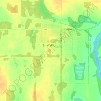
Name: St. Walburg topographic map, elevation, terrain.
Location: St. Walburg, Saskatchewan, S0M 2T0, Canada (53.62064 -109.21232 53.63850 -109.18776)
Average elevation: 2,106 ft
Minimum elevation: 2,041 ft
Maximum elevation: 2,146 ft
Make a donation
Gear up for your next adventure:
As an Amazon Associate, this site earns from qualifying purchases at no extra cost to you.
Other topographic maps
Click on a map to view its topography, its elevation and its terrain.
Make a donation
Gear up for your next adventure:
As an Amazon Associate, this site earns from qualifying purchases at no extra cost to you.
Make a donation
Gear up for your next adventure:
As an Amazon Associate, this site earns from qualifying purchases at no extra cost to you.
Whitecap Dakota First Nation
Canada > Saskatchewan > Whitecap Dakota First Nation
Average elevation: 1,624 ft
Morin Lake
Canada > Saskatchewan > Northern Saskatchewan Administration District > Morin Lake
Average elevation: 1,263 ft
Make a donation
Gear up for your next adventure:
As an Amazon Associate, this site earns from qualifying purchases at no extra cost to you.
Make a donation
Gear up for your next adventure:
As an Amazon Associate, this site earns from qualifying purchases at no extra cost to you.
Black Lake
Canada > Saskatchewan > Northern Saskatchewan Administration District > Black Lake
Average elevation: 961 ft
Make a donation
Gear up for your next adventure:
As an Amazon Associate, this site earns from qualifying purchases at no extra cost to you.
La Loche
Canada > Saskatchewan > Northern Saskatchewan Administration District > La Loche
Average elevation: 1,467 ft
Waterloo Lake
Canada > Saskatchewan > Northern Saskatchewan Administration District
Average elevation: 938 ft
Make a donation
Gear up for your next adventure:
As an Amazon Associate, this site earns from qualifying purchases at no extra cost to you.
Air Ronge
Canada > Saskatchewan > Northern Saskatchewan Administration District > Air Ronge
Average elevation: 1,211 ft
Garson Lake
Canada > Saskatchewan > Northern Saskatchewan Administration District > Garson Lake
Average elevation: 1,542 ft
Stony Rapids
Canada > Saskatchewan > Northern Saskatchewan Administration District
Average elevation: 745 ft
Make a donation
Gear up for your next adventure:
As an Amazon Associate, this site earns from qualifying purchases at no extra cost to you.
Hall Lake
Canada > Saskatchewan > Northern Saskatchewan Administration District > Hall Lake
Average elevation: 1,283 ft
Zeden Lake
Canada > Saskatchewan > Northern Saskatchewan Administration District
Average elevation: 1,726 ft
Make a donation
Gear up for your next adventure:
As an Amazon Associate, this site earns from qualifying purchases at no extra cost to you.