Geolocate

Ortnevik topographic map

Click on the map to display elevation.

About this map

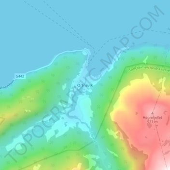
Name: Ortnevik topographic map, elevation, terrain.

Location: Ortnevik, Høyanger, Vestland, Norway (61.08826 6.11130 61.12826 6.15130)

Average elevation: 735 ft

Minimum elevation: -3 ft

Maximum elevation: 3,593 ft

Other topographic maps

Click on a map to view its topography, its elevation and its terrain.

Voss

Norway > Vestland

Average elevation: 2,510 ft

Tysnes

Norway > Vestland

Average elevation: 318 ft

Lærdal

Norway > Vestland

Average elevation: 3,789 ft

Austevoll

Norway > Vestland

Average elevation: 20 ft

Vik

Norway > Vestland

Average elevation: 2,425 ft

Sveio

Norway > Vestland

Average elevation: 187 ft

Kvam herad

Norway > Vestland

Average elevation: 1,677 ft

Sogndal

Norway > Vestland

Average elevation: 2,379 ft

Bjørnafjorden

Norway > Vestland

Average elevation: 30 ft

Høyanger

Norway > Vestland

Average elevation: 1,732 ft

Gear up for your next adventure:

👟Trail Running Shoes - Lightweight shoes for trail runners
📡Handheld GPS Device - Reliable handheld GPS for outdoor navigation
🧦Hiking Socks - Comfortable socks to prevent blisters on long hikes
🌄Hiking Binoculars - Compact binoculars for scenic views and trail spotting
🥾Hiking Shoes - Durable and comfortable shoes for trail hiking

As an Amazon Associate, this site earns from qualifying purchases at no extra cost to you.