Huila topographic map
Click on the map to display elevation.
About this map
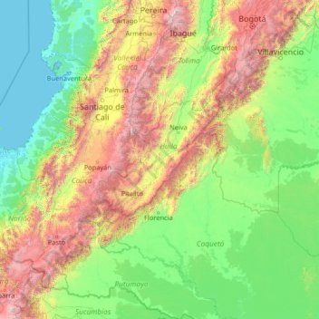
Name: Huila topographic map, elevation, terrain.
Location: Huila, Región Andina, Colombia (-0.12610 -78.19001 5.07390 -72.99001)
Average elevation: 3,130 ft
Minimum elevation: -7 ft
Maximum elevation: 17,943 ft
Other topographic maps
Click on a map to view its topography, its elevation and its terrain.
Bogota
Colombia > Bogota, Capital District
The city is located in the center of Colombia, on a high plateau known as the Bogotá savanna, part of the Altiplano Cundiboyacense located in the Eastern Cordillera of the Andes. Its altitude averages 2,640 meters (8,660 ft) above sea level, making it the third highest capital city in the world. Subdivided…
Average elevation: 8,894 ft

Medellín
Medellín has 16 comunas (districts), 5 corregimientos (townships), and 271 barrios (neighborhoods). The metropolitan area of Medellín lies within the Aburrá valley at an elevation of 1,500 meters (4,900 feet) above sea level and is bisected by the Medellín River (also called Porce), which flows northward.…
Average elevation: 6,795 ft

Antioquia
Due to its geographical isolation (as it is located among mountains), Antioquia suffered supply problems. Its topography did not allow for much agriculture, so the city became dependent upon trade, especially of gold and gin for the colonization of new land. Much of this trade was due to reforms passed after a…
Average elevation: 1,995 ft
Bogota
Colombia > Bogota, Capital District
The city is located in the center of Colombia, on a high plateau known as the Bogotá savanna, part of the Altiplano Cundiboyacense located in the Eastern Cordillera of the Andes. Its altitude averages 2,640 meters (8,660 ft) above sea level, making it the third highest capital city in the world. Subdivided…
Average elevation: 8,894 ft

Puerto Carreño
The area of the municipality is within the llanos plains which cover large areas in Colombia and Venezuela that are rich in biodiversity. Geologically the municipality of Puerto Carreño lies on the Guiana Shield mostly made up by Cenozoic and Precambric formations, with some low altitude mountains such as the…
Average elevation: 636 ft
Medellín
Medellín has 16 comunas (districts), 5 corregimientos (townships), and 271 barrios (neighborhoods). The metropolitan area of Medellín lies within the Aburrá valley at an elevation of 1,500 meters (4,900 feet) above sea level and is bisected by the Medellín River (also called Porce), which flows northward.…
Average elevation: 6,795 ft
Olaya
Olaya is a town and municipality located in the western region of the Department of Antioquia in the Republic of Colombia. It borders to the north with the municipality of Liborina, to the east with the municipalities of Belmira and Sopetrán and to the South with Sopetrán and by the West with the…
Average elevation: 3,123 ft




Floridablanca
Floridablanca (Spanish pronunciation: [floˌɾiðaˈβlaŋka], locally also simply Florida) is a municipality in the department of Santander situated at an altitude of 925 metres (3,035 ft) in the Eastern Ranges of the Colombian Andes. It is part of the metropolitan area of the departmental capital…
Average elevation: 4,134 ft


Cogua
Cogua (Spanish pronunciation: [ˈkoɣwa]) is a municipality and town of Colombia in the department of Cundinamarca. It is situated on northern part of the Bogotá savanna with the urban centre at an altitude of 2,600 metres (8,500 ft) at 50 kilometres (31 mi) from the capital Bogotá. Cogua borders Tausa in…
Average elevation: 9,606 ft


San José del Palmar
San José del Palmar has a tropical rainforest climate with heavy rainfall and warm to very warm, cloudy weather year-round, although the city's altitude means it is less hot and wet than the lowlands of Chocó Department. The general characteristics of the climate approximately coincide with the middle…
Average elevation: 4,610 ft
San José del Palmar
San José del Palmar has a tropical rainforest climate with heavy rainfall and warm to very warm, cloudy weather year-round, although the city's altitude means it is less hot and wet than the lowlands of Chocó Department. The general characteristics of the climate approximately coincide with the middle…
Average elevation: 4,610 ft
Medellín
Medellín has 16 comunas (districts), 5 corregimientos (townships), and 271 barrios (neighborhoods). The metropolitan area of Medellín lies within the Aburrá valley at an elevation of 1,500 meters (4,900 feet) above sea level and is bisected by the Medellín River (also called Porce), which flows northward.…
Average elevation: 6,795 ft


Armenia
Armenia has a territorial area of 29,743 square kilometres (11,484 sq mi). The terrain is mostly mountainous, with fast flowing rivers, and few forests. The land rises to 4,090 metres (13,419 feet) above sea level at Mount Aragats, and no point is below 390 metres (1,280 ft) above sea level. Average elevation…
Average elevation: 4,275 ft


Aquitania
Aquitania is a town and municipality in Boyacá Department, Colombia, part of the Sugamuxi Province, a subregion of Boyaca. Aquitania borders Sogamoso, Cuítiva and Mongua in the north, Zetaquirá, San Eduardo and Páez in the south, Labranzagrande, Pajarito, Recetor and Chámeza in the east and Cuítiva,…
Average elevation: 8,514 ft

Leticia
Leticia (Spanish pronunciation: [leˈtisja]) is the southernmost city in the Republic of Colombia, capital of the department of Amazonas, Colombia's southernmost town (4.09° south 69.57° west) and one of the major ports on the Amazon River. It has an elevation of 96 meters (315') above sea level and an…
Average elevation: 318 ft
Bogota
Colombia > Bogota, Capital District
The city is located in the center of Colombia, on a high plateau known as the Bogotá savanna, part of the Altiplano Cundiboyacense located in the Eastern Cordillera of the Andes. Its altitude averages 2,640 meters (8,660 ft) above sea level, making it the third highest capital city in the world. Subdivided…
Average elevation: 8,894 ft


Cali
Under Köppen's climate classification, Cali features a dry-summer tropical savanna climate (Köppen climate classification: As), closely bordering a tropical monsoon climate (Köppen: Am). The Western Mountain Range rises from an average of 2,000 m (6,562 ft) above sea level in the northern part of the city…
Average elevation: 4,213 ft
Boyacá
The department of Boyacá covers a small portion of the Middle Magdalena valley of the Magdalena River to the west, the Cordillera Oriental mountain range with altitudes of 5,380 m above sea level (Sierra Nevada del Cocuy with 25 snow peaks), flat highland plateaux, and another small portion of territory by…
Average elevation: 4,600 ft

Magdalena
The Department of Magdalena, because of its terrain, and proximity to the sea has an unstable weather. Its climate is mainly dictated by its global positioning, and because the department of Magdalena is located on the Intertropical Convergence Zone it possess an inter-tropical climate. Temperature in the…
Average elevation: 1,335 ft
Perimetro Urbano Pereira
Pereira, like many Colombian cities, has high-elevation areas with difficult access or flat or steep parts. The streets are laid out according to the elevation of the respective zones.
Average elevation: 4,875 ft
Cali
Under Köppen's climate classification, Cali features a dry-summer tropical savanna climate (Köppen climate classification: As). The Western Mountain Range rises from an average of 2,000 m (6,562 ft) above sea level in the northern part of the city to approximately 4,000 m (13,123 ft) to the south. Because of…
Average elevation: 4,213 ft
Bogota
Colombia > Bogota, Capital District
The city is located in the center of Colombia, on a high plateau known as the Bogotá savanna, part of the Altiplano Cundiboyacense located in the Eastern Cordillera of the Andes. Its altitude averages 2,640 meters (8,660 ft) above sea level, making it the third highest capital city in the world. Subdivided…
Average elevation: 8,894 ft
Cali
Under Köppen's climate classification, Cali features a dry-summer tropical monsoon climate (Köppen climate classification: Am), bordering a tropical savanna climate (Köppen: As). The Western Mountain Range rises from an average of 2,000 m (6,562 ft) above sea level in the northern part of the city to…
Average elevation: 5,157 ft
Villa de Leyva
Located away from major trade routes in a high altitude valley of semi-desert terrain, and with no mineral deposits nearby to exploit, the town has undergone little development in the last 400 years. As a consequence, it is one of the few towns in Colombia to have preserved much of its original colonial style…
Average elevation: 7,927 ft
Parque Nacional Natural Los Nevados
At the end of the 19th century, six glaciers existed on the peaks of El Ruiz, Santa Isabel, Tolima, El Cisne, Quindío and the current Paramillo de Santa Rosa, and were located at an altitude of 4500 meters above sea level.
Average elevation: 11,007 ft

Medellín
Medellín has 16 comunas (districts), 5 corregimientos (townships), and 271 barrios (neighborhoods). The metropolitan area of Medellín lies within the Aburrá valley at an elevation of 1,500 meters (4,900 feet) above sea level and is bisected by the Medellín River (also called Porce), which flows northward.…
Average elevation: 6,795 ft

Medellín
Medellín has 16 comunas (districts), 5 corregimientos (townships), and 271 barrios (neighborhoods). The metropolitan area of Medellín lies within the Aburrá valley at an elevation of 1,500 meters (4,900 feet) above sea level and is bisected by the Medellín River (also called Porce), which flows northward.…
Average elevation: 6,175 ft
Magdalena
The Department of Magdalena, because of its terrain, and proximity to the sea has an unstable weather. Its climate is mainly dictated by its global positioning, and because the department of Magdalena is located on the Intertropical Convergence Zone it possess an inter-tropical climate. Temperature in the…
Average elevation: 1,335 ft
Cali
Colombia > Valle del Cauca > Cali
Under Köppen's climate classification, Cali features a dry-summer tropical savanna climate (Köppen climate classification: As). The Western Mountain Range rises from an average of 2,000 m (6,562 ft) above sea level in the northern part of the city to approximately 4,000 m (13,123 ft) to the south. Because of…
Average elevation: 3,747 ft
Bogota
Colombia > Bogota, Capital District
The city is located in the center of Colombia, on a high plateau known as the Bogotá savanna, part of the Altiplano Cundiboyacense located in the Eastern Cordillera of the Andes. Its altitude averages 2,640 meters (8,660 ft) above sea level. Subdivided into 20 localities, Bogotá covers an area of 1,587…
Average elevation: 8,894 ft

Comuna 14 - El Poblado
Colombia > Antioquia > Medellín
El Poblado consists of 1,432.58 hectares (3,540.0 acres), encompassing 39% of the Medellín municipality. It is located in the southeastern zone of the city towards the mountains of the Aburrá Valley. The Medellín River borders its western side, separating it from the Guayabal Commune and its elevation east…
Average elevation: 5,682 ft

Ibagué
Ibagué features a tropical rainforest climate under the Köppen climate classification, albeit a relatively cooler version of the climate due to the high altitude. Although the city does experience noticeably drier conditions during and around the months of January and July, the city has no true dry season…
Average elevation: 6,257 ft
Ibagué
Ibagué features a tropical rainforest climate under the Köppen climate classification, albeit a relatively cooler version of the climate due to the high altitude. Although the city does experience noticeably drier conditions during and around the months of January and July, the city has no true dry season…
Average elevation: 6,257 ft
Neiva
Due to its location near the equator and its low altitude, the city has a hot annual average climate with daytime temperatures ranging from 88 to 95 degrees Fahrenheit. It is about 300 kilometers / 186.4 miles (about a five-hour drive) from the Colombian capital, Bogotá.
Average elevation: 3,386 ft
Leticia
Leticia (Spanish pronunciation: [leˈtisja]) is the southernmost city in the Republic of Colombia, capital of the department of Amazonas, Colombia's southernmost town (4.09° south 69.57° west) and one of the major ports on the Amazon River. It has an elevation of 96 meters (315') above sea level and an…
Average elevation: 233 ft
Cali
Under Köppen's climate classification, Cali features a dry-summer tropical savanna climate (Köppen climate classification: As). The Western Mountain Range rises from an average of 2,000 m (6,562 ft) above sea level in the northern part of the city to approximately 4,000 m (13,123 ft) to the south. Because of…
Average elevation: 4,213 ft
Salento
The town of Salento itself lies on a plateau above the Quindío river valley. The section of the river valley from Salento to the head of the river is known as the Cocora valley. The town is located at an average altitude of 1895 meters above sea level, with steep drops to the valley floor at its northern and…
Average elevation: 7,661 ft
Villa de Leyva
Located away from major trade routes in a high altitude valley of semi-desert terrain, and with no mineral deposits nearby to exploit, the town has undergone little development in the last 400 years. As a consequence, it is one of the few towns in Colombia to have preserved much of its original colonial style…
Average elevation: 7,927 ft

Isla de San Andrés
Colombia > San Andrés and Providencia > La Loma
San Andrés is the largest of the island group in the Department of the Archipelago of San Andrés, Providence and Saint Catherine. San Andrés is located in the Caribbean Sea, about 750 km (470 mi) northwest of the coast of Colombia. The island is 13 km (8.1 mi) in length and 3 km (1.9 mi) in width. It has an…
Average elevation: 10 ft


Duitama
Duitama (Spanish pronunciation: [dwiˈtama]) is a city and municipality in the department of Boyacá. It is the capital of the Tundama Province. Duitama is located 195 kilometres (121 mi) northeast of Bogotá, the capital city of Colombia and 50 kilometres (31 mi) northeast of Tunja, the capital Boyacá.…
Average elevation: 9,905 ft

Nariño
Nariño has a diverse geography and varied climate according to altitude: hot in the plains of the Pacific and cold in the mountains, where most of the population resides, a situation that is repeated in a north-south direction. Other important cities include Tumaco and Ipiales.
Average elevation: 3,793 ft