
Make a donation
Gear up for your next adventure:
As an Amazon Associate, this site earns from qualifying purchases at no extra cost to you.
Vichada topographic map
Click on the map to display elevation.
Make a donation
Gear up for your next adventure:
As an Amazon Associate, this site earns from qualifying purchases at no extra cost to you.
About this map
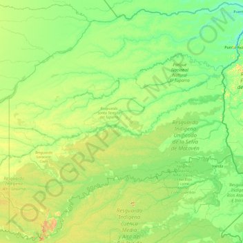
Name: Vichada topographic map, elevation, terrain.
Location: Vichada, RAP Llanos, Colombia (2.73675 -71.07780 6.32878 -67.40844)
Average elevation: 407 ft
Minimum elevation: 128 ft
Maximum elevation: 2,247 ft
Make a donation
Gear up for your next adventure:
As an Amazon Associate, this site earns from qualifying purchases at no extra cost to you.
Other topographic maps
Click on a map to view its topography, its elevation and its terrain.
Bogota
The city is located in the center of Colombia, on a high plateau known as the Bogotá savanna, part of the Altiplano Cundiboyacense located in the Eastern Cordillera of the Andes. Its altitude averages 2,640 meters (8,660 ft) above sea level. Subdivided into 20 localities, Bogotá has an area of 1,587 square…
Average elevation: 8,973 ft
Medellín
Colombia > Antioquia > Medellín
Medellín has 16 comunas (districts), 5 corregimientos (townships), and 271 barrios (neighborhoods). The metropolitan area of Medellín lies within the Aburrá valley at an elevation of 1,500 metres (4,900 feet) above sea level and is bisected by the Medellín River (also called Porce), which flows northward.…
Average elevation: 6,883 ft
Make a donation
Gear up for your next adventure:
As an Amazon Associate, this site earns from qualifying purchases at no extra cost to you.
Manizales
Manizales is the capital city of one of the smallest Colombian departments. The city is described as having an "abrupt topography", and lies on the Colombian Central Mountain Range (part of the longest continental mountain range, the Andes), with a great deal of ridgelines and steep slopes, which, combined…
Average elevation: 6,594 ft
Make a donation
Gear up for your next adventure:
As an Amazon Associate, this site earns from qualifying purchases at no extra cost to you.
San Andrés
Colombia > Archipelago of San Andrés, Providencia and Santa Catalina
It is situated at the north end of San Andrés Island in the Caribbean Sea, and forms part of the Colombian archipelago of San Andrés, Providencia and Santa Catalina. It is located about 710 km (440 mi) northwest of mainland Colombia, and 180 km (110 mi) off the eastern coast of Nicaragua. Spread across an…
Average elevation: 0 ft
Make a donation
Gear up for your next adventure:
As an Amazon Associate, this site earns from qualifying purchases at no extra cost to you.
Sierra Nevada de Santa Marta
Colombia > Magdalena > Aracataca
The Sierra Nevada de Santa Marta (English: Snow-Covered Mountain Range of Saint Martha) is an isolated mountain range in northern Colombia, separate from the Andes range that runs through the north of the country. Reaching an elevation of 5,700 m (18,700 ft) just 42 km (26 mi) from the Caribbean coast, the…
Average elevation: 16,447 ft
Make a donation
Gear up for your next adventure:
As an Amazon Associate, this site earns from qualifying purchases at no extra cost to you.
Andes
Andes is a municipality and town in the Antioquia Department, Colombia. Part of the sub-region of Southwestern Antioquia, it is located on the western Colombian Andes mountain range. Andes was founded on 13 March 1852 by Pedro Antonio Restrepo Escobar. Its elevation is 1,360 metres above sea level with an…
Average elevation: 5,115 ft
Make a donation
Gear up for your next adventure:
As an Amazon Associate, this site earns from qualifying purchases at no extra cost to you.
Pico Cristóbal Colón
Colombia > Magdalena > Santa Marta
Pico Cristóbal Colón is possibly the highest mountain in Colombia, with a reported height of 5,775 metres (18,947 ft). Pico Cristóbal Colón and Pico Simón Bolívar are the two highest peaks in Colombia and almost equal in elevation. One of the two mountains is therefore the fifth most prominent in the…
Average elevation: 16,768 ft
Make a donation
Gear up for your next adventure:
As an Amazon Associate, this site earns from qualifying purchases at no extra cost to you.
Leticia
Leticia (Spanish pronunciation: [leˈtisja]) is the southernmost city in the Republic of Colombia, capital of the department of Amazonas, Colombia's southernmost town (4.09° south 69.57° west) and one of the major ports on the Amazon River. It has an elevation of 96 meters (315') above sea level and an…
Average elevation: 233 ft
Andes
Andes is a municipality and town in the Antioquia Department, Colombia. Part of the sub-region of Southwestern Antioquia, it is located on the western Colombian Andes mountain range. Andes was founded on 13 March 1852 by Pedro Antonio Restrepo Escobar. Its elevation is 1,360 metres above sea level with an…
Average elevation: 5,115 ft
Make a donation
Gear up for your next adventure:
As an Amazon Associate, this site earns from qualifying purchases at no extra cost to you.
Rionegro
Colombia > Antioquia > Rionegro
The city of Rionegro is located at 6°9′18″N 75°22′48″W / 6.15500°N 75.38000°W / 6.15500; -75.38000, at an average elevation of 2,125 metres (6,972 ft) above sea level. The average annual precipitation varies between 1,800 and 2,500 millimetres (71 and 98 in) with an average temperature of…
Average elevation: 7,323 ft
Make a donation
Gear up for your next adventure:
As an Amazon Associate, this site earns from qualifying purchases at no extra cost to you.
Volcán Nevado del Ruiz
The summit of the volcano has steep slopes inclining from 20 to 30 degrees. At lower elevations, the slopes become less steep; their inclination is about 10 degrees. From there on, foothills stretch almost to the edge of the Magdalena River, north of the volcano and the Cauca River to the west. On the two…
Average elevation: 16,795 ft
Cerro de Monserrate
Colombia > Bogota, Capital District
Both Monserrate and its neighbor Guadalupe Hill are icons of Bogota's cityscape. The hill is a tourist attraction with access by funicular or cable car (both of which charge a fee) or the pilgrimage hiking trail (free). The hiking path is 2.4 km (1.5 mi), where you can walk up the steep hill on a journey that…
Average elevation: 9,462 ft
Make a donation
Gear up for your next adventure:
As an Amazon Associate, this site earns from qualifying purchases at no extra cost to you.
Tunja
Tunja has a population of 172,548 inhabitants according to the 2018 Census. 0.1% of the city is indigenous, 0.4% is black, and 99.5% is white and Mestizo. It is located in central Colombia, at an elevation ranging from approximately 2,700 metres (8,900 ft) to 2,900 metres (9,500 ft). The city centre is at an…
Average elevation: 9,265 ft
Cúcuta
Colombia > Norte de Santander > Cúcuta > Cúcuta
The city is in the eastern part of the Department of North Santander, in the Cordillera Oriental, close to the border with Venezuela. The city's area is 110 square kilometres (42 square miles) and its elevation is 320 metres (1,050 feet) above sea level.
Average elevation: 1,886 ft
Make a donation
Gear up for your next adventure:
As an Amazon Associate, this site earns from qualifying purchases at no extra cost to you.
Make a donation
Gear up for your next adventure:
As an Amazon Associate, this site earns from qualifying purchases at no extra cost to you.
Rionegro
Colombia > Antioquia > Rionegro
The city of Rionegro is located at 6°9′18″N 75°22′48″W / 6.15500°N 75.38000°W / 6.15500; -75.38000, at an average elevation of 2,125 metres (6,972 ft) above sea level. The average annual precipitation varies between 1,800 and 2,500 millimetres (71 and 98 in) with an average temperature of…
Average elevation: 7,323 ft
Make a donation
Gear up for your next adventure:
As an Amazon Associate, this site earns from qualifying purchases at no extra cost to you.
Sierra Nevada de Santa Marta
Colombia > Magdalena > Aracataca
The Sierra Nevada de Santa Marta (English: Snow-Covered Mountain Range of Saint Martha) is an isolated mountain range in northern Colombia, separate from the Andes range that runs through the north of the country. Reaching an elevation of 5,700 m (18,700 ft) just 42 km (26 mi) from the Caribbean coast, the…
Average elevation: 16,447 ft
Andes
Andes is a municipality and town in the Antioquia Department, Colombia. Part of the sub-region of Southwestern Antioquia, it is located on the western Colombian Andes mountain range. Andes was founded on 13 March 1852 by Pedro Antonio Restrepo Escobar. Its elevation is 1,360 metres above sea level with an…
Average elevation: 5,115 ft
Make a donation
Gear up for your next adventure:
As an Amazon Associate, this site earns from qualifying purchases at no extra cost to you.
Make a donation
Gear up for your next adventure:
As an Amazon Associate, this site earns from qualifying purchases at no extra cost to you.
Make a donation
Gear up for your next adventure:
As an Amazon Associate, this site earns from qualifying purchases at no extra cost to you.
Make a donation
Gear up for your next adventure:
As an Amazon Associate, this site earns from qualifying purchases at no extra cost to you.
Make a donation
Gear up for your next adventure:
As an Amazon Associate, this site earns from qualifying purchases at no extra cost to you.
Cajicá
Cajicá is a municipality and town of Colombia in the department of Cundinamarca, 39 km (24 mi) north of the capital Bogotá. It is located in the Central Savanna Province, being the third most populous municipality in the province after Zipaquirá and Chía. It is bordered by the municipalities of Zipaquirá…
Average elevation: 8,566 ft
Make a donation
Gear up for your next adventure:
As an Amazon Associate, this site earns from qualifying purchases at no extra cost to you.
Palomino
Colombia > La Guajira > Dibulla
Palomino is located in the municipality of Dibulla part of the department of Guajira and is only 2 meters above sea level. It is one of the five towns that form the municipality of Dibulla. It is located on the foothills of the Sierra Nevada Mountains of Colombia. The Sierra Nevada de Santa Marta, declared as…
Average elevation: 167 ft
Make a donation
Gear up for your next adventure:
As an Amazon Associate, this site earns from qualifying purchases at no extra cost to you.
Make a donation
Gear up for your next adventure:
As an Amazon Associate, this site earns from qualifying purchases at no extra cost to you.
Cordillera Oriental
The Cordillera Oriental montane forests ecoregion covers the eastern slopes of the cordillera and its northern end. The Magdalena Valley montane forests cover the western slopes. The Northern Andean páramo covers the highest elevations.
Average elevation: 15,830 ft
Make a donation
Gear up for your next adventure:
As an Amazon Associate, this site earns from qualifying purchases at no extra cost to you.
Andes
Andes is a municipality and town in the Antioquia Department, Colombia. Part of the sub-region of Southwestern Antioquia, it is located on the western Colombian Andes mountain range. Andes was founded on 13 March 1852 by Pedro Antonio Restrepo Escobar. Its elevation is 1,360 metres above sea level with an…
Average elevation: 5,115 ft
Make a donation
Gear up for your next adventure:
As an Amazon Associate, this site earns from qualifying purchases at no extra cost to you.
Make a donation
Gear up for your next adventure:
As an Amazon Associate, this site earns from qualifying purchases at no extra cost to you.
Make a donation
Gear up for your next adventure:
As an Amazon Associate, this site earns from qualifying purchases at no extra cost to you.
Make a donation
Gear up for your next adventure:
As an Amazon Associate, this site earns from qualifying purchases at no extra cost to you.