
Garda topographic map
Click on the map to display elevation.
About this map
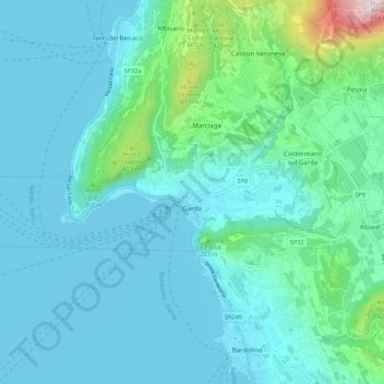
Name: Garda topographic map, elevation, terrain.
Location: Garda, Verona, Veneto, 37016, Italy (45.56713 10.63096 45.59061 10.73965)
Average elevation: 568 ft
Minimum elevation: 200 ft
Maximum elevation: 2,877 ft
Other topographic maps
Click on a map to view its topography, its elevation and its terrain.
Monte Pastello
Italy > Veneto > Verona > Fumane
Monte Pastello is a mountain of the Veneto, Italy. The mountain, which has an elevation of 1,128 metres, is part of the Monti Lessini in the Venetian Prealps. It is located in the Province of Verona.
Average elevation: 2,290 ft