
Kenora topographic map
Click on the map to display elevation.
About this map
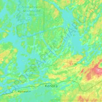
Name: Kenora topographic map, elevation, terrain.
Average elevation: 1,102 ft
Minimum elevation: 1,020 ft
Maximum elevation: 1,394 ft
Other topographic maps
Click on a map to view its topography, its elevation and its terrain.
Sioux Narrows
Canada > Ontario > Kenora District > Sioux Narrows-Nestor Falls Township
Average elevation: 1,079 ft
Carroll Lake
Canada > Ontario > Kenora District > Unorganized Kenora District
Average elevation: 1,109 ft
Burditt Lake
Canada > Ontario > Kenora District > Unorganized Kenora District
Average elevation: 1,204 ft
Granite Lake
Canada > Ontario > Kenora District > Unorganized Kenora District
Average elevation: 1,165 ft
Nestor Falls
Canada > Ontario > Kenora District > Sioux Narrows-Nestor Falls Township
Average elevation: 1,106 ft
Shoal Lake
Canada > Ontario > Kenora District > Unorganized Kenora District
Average elevation: 1,066 ft
Look Lake
Canada > Ontario > Kenora District > Unorganized Kenora District
Average elevation: 1,289 ft
Wolf Island
Canada > Ontario > Kenora District > Unorganized Kenora District
Average elevation: 1,073 ft
Cardinal (Lac) Lake
Canada > Ontario > Kenora District > Unorganized Kenora District
Average elevation: 1,286 ft
Hudson Bay Lowlands
Canada > Ontario > Kenora District > Unorganized Kenora District
Average elevation: 56 ft
Caliper Lake Provincial Park
Canada > Ontario > Kenora District > Sioux Narrows-Nestor Falls Township
Average elevation: 1,109 ft
Big Island Lake
Canada > Ontario > Kenora District > Unorganized Kenora District
Average elevation: 1,411 ft
Arpin Lake
Canada > Ontario > Kenora District > Unorganized Kenora District
Average elevation: 1,257 ft
Mills Lake
Canada > Ontario > Kenora District > Unorganized Kenora District
Average elevation: 1,247 ft
Beauty Lake
Canada > Ontario > Kenora District > Unorganized Kenora District
Average elevation: 1,142 ft
Clearwater Bay
Canada > Ontario > Kenora District > Unorganized Kenora District
Average elevation: 1,096 ft
Boyne Lake
Canada > Ontario > Kenora District > Unorganized Kenora District
Average elevation: 1,184 ft
Slate Falls
Canada > Ontario > Kenora District > Unorganized Kenora District
Average elevation: 1,263 ft
Wabauskang 21
Canada > Ontario > Kenora District > Unorganized Kenora District
Average elevation: 1,207 ft
Canyon Lake
Canada > Ontario > Kenora District > Unorganized Kenora District
Average elevation: 1,329 ft
Dingwall Island
Canada > Ontario > Kenora District > Unorganized Kenora District
Average elevation: 1,066 ft
Gordon Island
Canada > Ontario > Kenora District > Unorganized Kenora District
Average elevation: 1,145 ft
Twin Lake
Canada > Ontario > Kenora District > Unorganized Kenora District
Average elevation: 1,309 ft
Clear Lake
Canada > Ontario > Kenora District > Unorganized Kenora District
Average elevation: 1,204 ft
Grindstone Lake
Canada > Ontario > Kenora District > Unorganized Kenora District
Average elevation: 1,217 ft
Warwick Lake
Canada > Ontario > Kenora District > Unorganized Kenora District
Average elevation: 1,119 ft
Slate Islands
Canada > Ontario > Kenora District > Unorganized Kenora District
Average elevation: 1,056 ft
Nine Mile Lake
Canada > Ontario > Kenora District > Unorganized Kenora District
Average elevation: 1,355 ft
Betula Lake
Canada > Ontario > Kenora District > Unorganized Kenora District
Average elevation: 1,217 ft
Squirrel Lake
Canada > Ontario > Kenora District > Sioux Narrows-Nestor Falls Township
Average elevation: 1,181 ft
Chisholm Island
Canada > Ontario > Kenora District > Unorganized Kenora District
Average elevation: 1,060 ft
Muskeg River
Canada > Ontario > Kenora District > Unorganized Kenora District
Average elevation: 1,171 ft
Mackey Island
Canada > Ontario > Kenora District > Unorganized Kenora District
Average elevation: 1,102 ft
Sioux Narrows Provincial Park
Canada > Ontario > Kenora District > Sioux Narrows-Nestor Falls Township
Average elevation: 1,079 ft
Muskeg River
Canada > Ontario > Kenora District > Unorganized Kenora District
Average elevation: 1,191 ft
Potter's Pond
Canada > Ontario > Kenora District > Ignace Township > Ignace
Average elevation: 1,503 ft
Tablerock Lake
Canada > Ontario > Kenora District > Unorganized Kenora District
Average elevation: 1,260 ft
Little Boulder Lake
Canada > Ontario > Kenora District > Unorganized Kenora District
Average elevation: 1,178 ft
Cameron Island
Canada > Ontario > Kenora District > Unorganized Kenora District
Average elevation: 1,109 ft
Nestor Falls
Canada > Ontario > Kenora District > Sioux Narrows-Nestor Falls Township
Average elevation: 1,106 ft