
Fort Severn topographic map
Click on the map to display elevation.
About this map
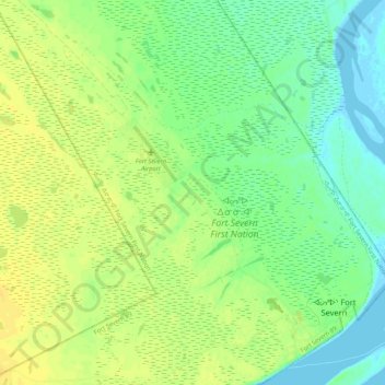
Name: Fort Severn topographic map, elevation, terrain.
Average elevation: 36 ft
Minimum elevation: -10 ft
Maximum elevation: 66 ft
Other topographic maps
Click on a map to view its topography, its elevation and its terrain.
Dogtooth Lake
Canada > Ontario > Kenora District > Unorganized Kenora District
Average elevation: 1,184 ft
lac Seul
Canada > Ontario > Kenora District > Unorganized Kenora District
Lac Seul is a large, crescent shaped reservoir in Kenora District, northwestern Ontario, Canada. It is approximately 241 km (150 mi) long. It has a maximum (regulated) depth of 47.2 m, with a surface elevation of 357 m above sea level. Its level is raised in the summer and then drawn down in the winter months…
Average elevation: 1,227 ft
MacDowell Lake
Canada > Ontario > Kenora District > Unorganized Kenora District
Average elevation: 1,266 ft
Rowdy Lake
Canada > Ontario > Kenora District > Unorganized Kenora District
Average elevation: 1,214 ft
Sioux Narrows
Canada > Ontario > Kenora District > Sioux Narrows-Nestor Falls Township
Average elevation: 1,079 ft
Lake Charles
Canada > Ontario > Kenora District > Unorganized Kenora District
Average elevation: 1,135 ft
Northwest Angle 33 First Nation
Canada > Ontario > Kenora District > Whitefish Bay
Average elevation: 1,089 ft
Fiddler Lake
Canada > Ontario > Kenora District > Unorganized Kenora District
Average elevation: 961 ft
Nestor Falls
Canada > Ontario > Kenora District > Sioux Narrows-Nestor Falls Township
Average elevation: 1,106 ft
Big Canon Lake
Canada > Ontario > Kenora District > Unorganized Kenora District
Average elevation: 1,191 ft
Star Lake
Canada > Ontario > Kenora District > Unorganized Kenora District
Average elevation: 1,253 ft
Hudson Bay Lowlands
Canada > Ontario > Kenora District > Unorganized Kenora District
Average elevation: 56 ft
Sioux Lookout
Canada > Ontario > Kenora District
Sioux Lookout is located approximately 350 kilometres (220 mi) northwest of Thunder Bay, at an elevation of 383 metres (1,257 ft), and it covers an area of 536 square kilometres (207 sq mi), of which 157 square kilometres (61 sq mi) is lake and wetlands.
Average elevation: 1,237 ft
Minnitaki Lake
Canada > Ontario > Kenora District > Unorganized Kenora District
Average elevation: 1,266 ft
Artery Lake
Canada > Ontario > Kenora District > Unorganized Kenora District
Average elevation: 1,096 ft
Maynard Lake
Canada > Ontario > Kenora District > Unorganized Kenora District
Average elevation: 1,106 ft
Clearwater Bay
Canada > Ontario > Kenora District > Unorganized Kenora District
Average elevation: 1,096 ft
Whitefish Lake
Canada > Ontario > Kenora District > Unorganized Kenora District
Average elevation: 1,247 ft
Slate Falls
Canada > Ontario > Kenora District > Unorganized Kenora District
Average elevation: 1,263 ft
Wabauskang 21
Canada > Ontario > Kenora District > Unorganized Kenora District
Average elevation: 1,207 ft
Canyon Lake
Canada > Ontario > Kenora District > Unorganized Kenora District
Average elevation: 1,329 ft
Kushog Lake
Canada > Ontario > Kenora District > Unorganized Kenora District
Average elevation: 1,329 ft
Confederation Lake
Canada > Ontario > Kenora District > Unorganized Kenora District
Average elevation: 1,358 ft
Fredart Lake
Canada > Ontario > Kenora District > Unorganized Kenora District
Average elevation: 1,342 ft
Two Island Lake
Canada > Ontario > Kenora District > Unorganized Kenora District
Average elevation: 1,184 ft
Affleck Lake
Canada > Ontario > Kenora District > Unorganized Kenora District
Average elevation: 1,381 ft
Spadina Lake
Canada > Ontario > Kenora District > Unorganized Kenora District
Average elevation: 1,234 ft
McIntosh Lake
Canada > Ontario > Kenora District > Unorganized Kenora District
Average elevation: 1,296 ft
Gordon Island
Canada > Ontario > Kenora District > Unorganized Kenora District
Average elevation: 1,145 ft
Blackstone Lake
Canada > Ontario > Kenora District > Unorganized Kenora District
Average elevation: 1,253 ft
Bass Lake
Canada > Ontario > Kenora District > Unorganized Kenora District
Average elevation: 1,270 ft
Winnipeg River
Canada > Ontario > Kenora District > Unorganized Kenora District
Average elevation: 1,040 ft
Shoal Lake
Canada > Ontario > Kenora District > Unorganized Kenora District
Average elevation: 1,066 ft
Cygnet Lake
Canada > Ontario > Kenora District > Unorganized Kenora District
Average elevation: 1,112 ft
Lac Seul
Canada > Ontario > Kenora District
Lac Seul is a large, crescent-shaped reservoir in Kenora District, northwestern Ontario, Canada. It is approximately 241 km (150 mi) long. It has a maximum (regulated) depth of 47.2 m, with a surface elevation of 357 m above sea level. Its level is raised in the summer and then drawn down in the winter months…
Average elevation: 1,273 ft
Brock Lake
Canada > Ontario > Kenora District > Unorganized Kenora District
Average elevation: 1,020 ft
Bertrand Lake
Canada > Ontario > Kenora District > Unorganized Kenora District
Average elevation: 1,358 ft
Betula Lake
Canada > Ontario > Kenora District > Unorganized Kenora District
Average elevation: 1,217 ft
Stormy Lake
Canada > Ontario > Kenora District > Unorganized Kenora District
Average elevation: 1,358 ft
Mackey Island
Canada > Ontario > Kenora District > Unorganized Kenora District
Average elevation: 1,102 ft
Snelgrove Lake
Canada > Ontario > Kenora District > Unorganized Kenora District
Average elevation: 1,339 ft
Eagle Lake
Canada > Ontario > Kenora District > Unorganized Kenora District
Average elevation: 1,243 ft
Wabaskang Lake
Canada > Ontario > Kenora District > Unorganized Kenora District
Average elevation: 1,230 ft
Minnitaki Lake
Canada > Ontario > Kenora District > Unorganized Kenora District
Average elevation: 1,266 ft
Kukukus Lake
Canada > Ontario > Kenora District > Unorganized Kenora District
Average elevation: 1,329 ft
Antenna Lake
Canada > Ontario > Kenora District > Unorganized Kenora District
Average elevation: 1,289 ft
Berry Lake
Canada > Ontario > Kenora District > Sioux Narrows-Nestor Falls Township
Average elevation: 1,115 ft
Cluster Lakes
Canada > Ontario > Kenora District > Unorganized Kenora District
Average elevation: 1,453 ft
Swan Lake
Canada > Ontario > Kenora District > Unorganized Kenora District
Average elevation: 1,060 ft
Cameron Island
Canada > Ontario > Kenora District > Unorganized Kenora District
Average elevation: 1,109 ft
Nestor Falls
Canada > Ontario > Kenora District > Sioux Narrows-Nestor Falls Township
Average elevation: 1,106 ft