
East Champaran District topographic map
Interactive map
Click on the map to display elevation.
About this map
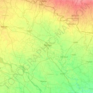
Name: East Champaran District topographic map, elevation, terrain.
Location: East Champaran District, Bihar, India (26.25457 84.48528 27.02168 85.29697)
Average elevation: 230 ft
Minimum elevation: 164 ft
Maximum elevation: 331 ft
Raxaul is one of the most significant towns of the East Champaran district. By excellence of its topographical area, it is known as the Gateway to Nepal.
Other topographic maps
Click on a map to view its topography, its elevation and its terrain.
Sonbhadra
India > Bihar > Sonbhadra Banshi Suryapur
Sonbhadra, Sonbhadra Banshi Suryapur, Arwal District, Bihar, 824120, India
Average elevation: 243 ft
Samastipur
Samastipur, Samastipur District, Bihar, 848101, India
Average elevation: 157 ft
Kishanganj
Kishanganj, Madhepura District, Bihar, 852115, India
Average elevation: 128 ft
Pashchim Champāran
Pashchim Champāran, Pashchim Champaran, Bihar, India
Average elevation: 679 ft
Sultanganj
India > Bihar > Sultanganj
Sultanganj, Bhagalpur, Bihar, 813223, India
Average elevation: 125 ft
Patna
India > Bihar > Patna Rural
Patna, Patna Rural, Patna District, Bihar, 800001, India
Average elevation: 167 ft