Geolocate

Tyler topographic map

Click on the map to display elevation.

About this map

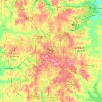
Name: Tyler topographic map, elevation, terrain.

Location: Tyler, Smith County, Texas, United States (32.23067 -95.41888 32.46788 -95.19329)

Average elevation: 482 ft

Minimum elevation: 299 ft

Maximum elevation: 666 ft

Smith County trails, hiking, mountain biking, running and outdoor activities

Other topographic maps

Click on a map to view its topography, its elevation and its terrain.

Swan

United States > Texas > Smith County

Average elevation: 512 ft

Thedford

United States > Texas > Smith County > Lindale

Average elevation: 509 ft

Fun Forest Park

United States > Texas > Smith County > Tyler

Average elevation: 535 ft

Owentown

United States > Texas > Smith County

Average elevation: 397 ft

Whitehouse

United States > Texas > Smith County

Average elevation: 466 ft

Tyler

United States > Texas > Smith County > Tyler

Average elevation: 466 ft

Pine Springs

United States > Texas > Smith County > Tyler > Pine Springs

Average elevation: 509 ft

Tyler

United States > Texas > Smith County

Average elevation: 482 ft

Gear up for your next adventure:

Solar GPS Watches - Advanced multisport watches with built-in topographic maps
🗺️NatGeo Topo Maps - High-quality waterproof printed topographic maps of US Parks
🔌USB Car Charger - Car charger for on‑the‑go power needs
🦶Carbon Trekking Poles - Reduce knee impact on steep descents with ultra-light poles
🔥Camping Stove - Portable stove for camping and backcountry cooking

As an Amazon Associate, this site earns from qualifying purchases at no extra cost to you.