
Weber County topographic map
Interactive map
Click on the map to display elevation.
About this map
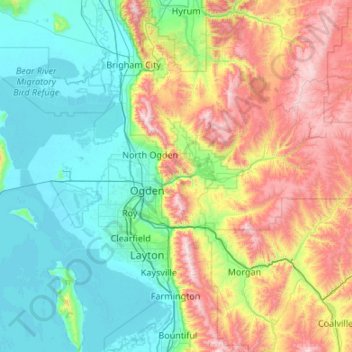
Name: Weber County topographic map, elevation, terrain.
Location: Weber County, Utah, United States (41.07684 -112.49348 41.43393 -111.42038)
Average elevation: 5,650 ft
Minimum elevation: 4,193 ft
Maximum elevation: 9,577 ft
The county extends from high in the Wasatch Range in the east into a portion of the Great Salt Lake to the west, where the county's elongated point exists. The Weber and Ogden rivers and their tributaries run through its valleys. The Weber County Surveyor's office divides the county into two regions, the "Lower Valley" and the "Upper Valley", divided by the ridge of the Wasatch front range south through the county. Lower Valley, adjacent to the Lake, is the county's more populous part. The Upper Valley consists mostly of the Ogden Valley, the watershed of the Ogden River. The county's highest elevation is Willard Peak in the Wasatch Mountains, at 9,763' (2976m) ASL. The county has an area of 659 square miles (1,710 km2), of which 576 square miles (1,490 km2) is land and 83 square miles (210 km2) (13%) is water. It is the second-smallest county in Utah by land area and third-smallest by total area.
Other topographic maps
Click on a map to view its topography, its elevation and its terrain.
Salt Lake City
United States > Utah > Salt Lake County
Salt Lake City, Salt Lake County, Utah, United States
Average elevation: 5,223 ft
Moab
United States > Utah > Grand County
Moab, Grand County, Utah, 84532, United States
Average elevation: 4,452 ft
Saint George
United States > Utah > Washington County
Saint George, Washington County, Utah, United States
Average elevation: 3,048 ft
Herriman
United States > Utah > Salt Lake County
Herriman, Salt Lake County, Utah, United States
Average elevation: 5,390 ft
Orem
United States > Utah > Utah County
Orem, Utah County, Utah, United States
Average elevation: 4,783 ft
Park City
United States > Utah > Summit County
Park City, Summit County, Utah, United States
Average elevation: 7,513 ft
Sandy
United States > Utah > Salt Lake County
Sandy, Salt Lake County, Utah, United States
Average elevation: 4,514 ft
Provo
United States > Utah > Utah County
Provo, Utah County, Utah, United States
Average elevation: 5,669 ft
Cedar City
United States > Utah > Iron County
Cedar City, Iron County, Utah, United States
Average elevation: 6,480 ft
Logan
United States > Utah > Cache County
Logan, Cache County, Utah, United States
Average elevation: 4,915 ft
Layton
United States > Utah > Davis County
Layton, Davis County, Utah, United States
Average elevation: 4,505 ft
West Jordan
United States > Utah > Salt Lake County
West Jordan, Salt Lake County, Utah, United States
Average elevation: 4,501 ft
Goshen
United States > Utah > Utah County
Goshen, Utah County, Utah, 84633, United States
Average elevation: 4,570 ft
Eagle Mountain
United States > Utah > Utah County
Eagle Mountain, Utah County, Utah, 84005, United States
Average elevation: 5,213 ft
Bountiful
United States > Utah > Davis County
Bountiful, Davis County, Utah, 84010, United States
Average elevation: 4,846 ft
Zion National Park
United States > Utah > Washington County
Zion National Park, Washington County, Utah, United States
Average elevation: 6,158 ft
Heber City
United States > Utah > Wasatch County > Heber > Heber City
Heber City, Heber, Wasatch County, Utah, 84032, United States
Average elevation: 5,771 ft
Kimball Junction
United States > Utah > Summit County > Kimball Junction
Kimball Junction, Summit County, Utah, 84098, United States
Average elevation: 6,575 ft
Allen Canyon
United States > Utah > San Juan County
Allen Canyon, San Juan County, Utah, United States
Average elevation: 6,398 ft
Campbell
United States > Utah > Davis County > Bountiful
Campbell, Bountiful, Davis County, Utah, 84014, United States
Average elevation: 4,419 ft
South Jordan
United States > Utah > Salt Lake County
South Jordan, Salt Lake County, Utah, 84095, United States
Average elevation: 4,616 ft
North Ogden
United States > Utah > Weber County
North Ogden, Weber County, Utah, 84414, United States
Average elevation: 4,803 ft
Taylorsville
United States > Utah > Salt Lake County
Taylorsville, Salt Lake County, Utah, United States
Average elevation: 4,347 ft
Lehi
United States > Utah > Utah County
Lehi, Utah County, Utah, 84043, United States
Average elevation: 4,806 ft
Trenton
United States > Utah > Cache County
Trenton, Cache County, Utah, 84338, United States
Average elevation: 4,567 ft
Hite Point
United States > Utah > Garfield County
Hite Point, Garfield County, Utah, United States
Average elevation: 4,423 ft
Lost Acres
United States > Utah > Salt Lake County
Lost Acres, Salt Lake County, Utah, United States
Average elevation: 7,641 ft
Garden
United States > Utah > Rich County > Garden City
Garden, Garden City, Rich County, Utah, United States
Average elevation: 6,890 ft
Cottonwood Heights
United States > Utah > Salt Lake County
Cottonwood Heights, Salt Lake County, Utah, United States
Average elevation: 4,823 ft
Benson
United States > Utah > Cache County
Benson, Cache County, Utah, United States
Average elevation: 4,731 ft
Plymouth
United States > Utah > Box Elder County
Plymouth, Box Elder County, Utah, United States
Average elevation: 4,564 ft
Riverside
United States > Utah > Box Elder County
Riverside, Box Elder County, Utah, 84334, United States
Average elevation: 4,400 ft
South Willard
United States > Utah > Box Elder County
South Willard, Box Elder County, Utah, 84340, United States
Average elevation: 4,649 ft
Peter
United States > Utah > Cache County > Petersboro
Peter, Petersboro, Cache County, Utah, United States
Average elevation: 4,741 ft
Lewiston
United States > Utah > Cache County
Lewiston, Cache County, Utah, 84320, United States
Average elevation: 4,514 ft
Soapstone Mountain
United States > Utah > Wasatch County
Soapstone Mountain, Wasatch County, Utah, United States
Average elevation: 8,924 ft
Hyrum
United States > Utah > Cache County
Hyrum, Cache County, Utah, 84319, United States
Average elevation: 4,721 ft
Pine Valley
United States > Utah > Washington County
Pine Valley, Washington County, Utah, 84781, United States
Average elevation: 6,864 ft
Howell
United States > Utah > Box Elder County
Howell, Box Elder County, Utah, 84316, United States
Average elevation: 4,790 ft
Clarkston
United States > Utah > Cache County
Clarkston, Cache County, Utah, 84305, United States
Average elevation: 4,915 ft
Echo
United States > Utah > Summit County
Echo, Summit County, Utah, 84024, United States
Average elevation: 5,879 ft
Monroe
United States > Utah > Sevier County
Monroe, Sevier County, Utah, 84754, United States
Average elevation: 5,505 ft
Pleasant View
United States > Utah > Weber County
Pleasant View, Weber County, Utah, United States
Average elevation: 4,747 ft
South Ogden
United States > Utah > Weber County
South Ogden, Weber County, Utah, 84405, United States
Average elevation: 4,603 ft
The Three Peaks
United States > Utah > Iron County
The Three Peaks, Iron County, Utah, United States
Average elevation: 5,869 ft
Desert Mountain
United States > Utah > Juab County
Desert Mountain, Juab County, Utah, United States
Average elevation: 5,489 ft
Dammeron Valley
United States > Utah > Washington County
Dammeron Valley, Washington County, Utah, 84783, United States
Average elevation: 4,738 ft
Lake Powell
United States > Utah > San Juan County
Lake Powell, San Juan County, Utah, United States
Average elevation: 5,102 ft
Linwood Bay
United States > Utah > Daggett County
Linwood Bay, Daggett County, Utah, United States
Average elevation: 6,076 ft
White City
United States > Utah > Salt Lake County
White City, Salt Lake County, Utah, United States
Average elevation: 4,603 ft