Make a donation
Gear up for your next adventure:
As an Amazon Associate, this site earns from qualifying purchases at no extra cost to you.
Golo topographic map
Click on the map to display elevation.
Make a donation
Gear up for your next adventure:
As an Amazon Associate, this site earns from qualifying purchases at no extra cost to you.
Golo
Golo is a clustered village with two settlement centers: the hamlets of Gorenje Golo (German: Obergolu) and Dolenje Golo (German: Untergolu). It lies along the road from Ig to Visoko northeast of Mount Mokrec (elevation: 1,059 meters or 3,474 feet). Golec Hill (elevation: 766 meters or 2,513 feet) rises to the southwest.
Make a donation
Gear up for your next adventure:
As an Amazon Associate, this site earns from qualifying purchases at no extra cost to you.
About this map
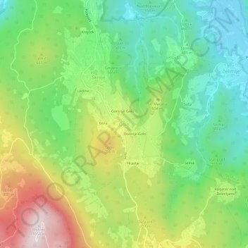
Name: Golo topographic map, elevation, terrain.
Location: Golo, Ig, Upravna Enota Ljubljana, Slovenia (45.89022 14.52677 45.93022 14.56677)
Average elevation: 1,900 ft
Minimum elevation: 978 ft
Maximum elevation: 3,419 ft
Make a donation
Gear up for your next adventure:
As an Amazon Associate, this site earns from qualifying purchases at no extra cost to you.
Other topographic maps
Click on a map to view its topography, its elevation and its terrain.
Triglav National Park
Systematic surveys of plants, especially of ethnobotanically useful species, in Triglav National Park have been carried out by Chandra Prakash Kala and Petra Ratajc covering various microhabitats, elevations, aspects, and terrain types. The park has over fifty-nine species of ethnobotanical values, of these 37…
Average elevation: 3,488 ft
Make a donation
Gear up for your next adventure:
As an Amazon Associate, this site earns from qualifying purchases at no extra cost to you.
Soča
An Alpine river in character, its source lies in the Trenta Valley in the Julian Alps in northwestern Slovenia, at an elevation of 876 metres (2,874 ft). The river runs past the towns of Bovec, Kobarid, Tolmin, Kanal ob Soči, Nova Gorica (where it is crossed by the Solkan Bridge), and Gorizia, entering the…
Average elevation: 2,041 ft
Make a donation
Gear up for your next adventure:
As an Amazon Associate, this site earns from qualifying purchases at no extra cost to you.
Make a donation
Gear up for your next adventure:
As an Amazon Associate, this site earns from qualifying purchases at no extra cost to you.
Make a donation
Gear up for your next adventure:
As an Amazon Associate, this site earns from qualifying purchases at no extra cost to you.
Make a donation
Gear up for your next adventure:
As an Amazon Associate, this site earns from qualifying purchases at no extra cost to you.
Make a donation
Gear up for your next adventure:
As an Amazon Associate, this site earns from qualifying purchases at no extra cost to you.
Make a donation
Gear up for your next adventure:
As an Amazon Associate, this site earns from qualifying purchases at no extra cost to you.
Soča
An Alpine river in character, its source lies in the Trenta Valley in the Julian Alps in northwestern Slovenia, at an elevation of 876 metres (2,874 ft). The river runs past the towns of Bovec, Kobarid, Tolmin, Kanal ob Soči, Nova Gorica (where it is crossed by the Solkan Bridge), and Gorizia, entering the…
Average elevation: 1,844 ft
Make a donation
Gear up for your next adventure:
As an Amazon Associate, this site earns from qualifying purchases at no extra cost to you.
Make a donation
Gear up for your next adventure:
As an Amazon Associate, this site earns from qualifying purchases at no extra cost to you.
Make a donation
Gear up for your next adventure:
As an Amazon Associate, this site earns from qualifying purchases at no extra cost to you.
Make a donation
Gear up for your next adventure:
As an Amazon Associate, this site earns from qualifying purchases at no extra cost to you.
