Make a donation
Gear up for your next adventure:
As an Amazon Associate, this site earns from qualifying purchases at no extra cost to you.
Savinja Statistical Region topographic map
Click on the map to display elevation.
Make a donation
Gear up for your next adventure:
As an Amazon Associate, this site earns from qualifying purchases at no extra cost to you.
About this map
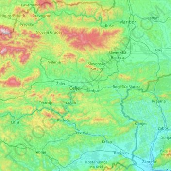
Name: Savinja Statistical Region topographic map, elevation, terrain.
Location: Savinja Statistical Region, Slovenia (45.99603 14.56504 46.48024 15.80158)
Average elevation: 1,490 ft
Minimum elevation: 400 ft
Maximum elevation: 6,841 ft
Make a donation
Gear up for your next adventure:
As an Amazon Associate, this site earns from qualifying purchases at no extra cost to you.
Other topographic maps
Click on a map to view its topography, its elevation and its terrain.
Make a donation
Gear up for your next adventure:
As an Amazon Associate, this site earns from qualifying purchases at no extra cost to you.
Make a donation
Gear up for your next adventure:
As an Amazon Associate, this site earns from qualifying purchases at no extra cost to you.
Make a donation
Gear up for your next adventure:
As an Amazon Associate, this site earns from qualifying purchases at no extra cost to you.
Make a donation
Gear up for your next adventure:
As an Amazon Associate, this site earns from qualifying purchases at no extra cost to you.
Soča
An Alpine river in character, its source lies in the Trenta Valley in the Julian Alps in northwestern Slovenia, at an elevation of 876 metres (2,874 ft). The river runs past the towns of Bovec, Kobarid, Tolmin, Kanal ob Soči, Nova Gorica (where it is crossed by the Solkan Bridge), and Gorizia, entering the…
Average elevation: 2,041 ft
Make a donation
Gear up for your next adventure:
As an Amazon Associate, this site earns from qualifying purchases at no extra cost to you.
Make a donation
Gear up for your next adventure:
As an Amazon Associate, this site earns from qualifying purchases at no extra cost to you.
Make a donation
Gear up for your next adventure:
As an Amazon Associate, this site earns from qualifying purchases at no extra cost to you.
Ljubljana
Ljubljana has an elevation of 295 meters (968 ft) The city centre, located along the Ljubljanica River, has an elevation of 298 meters (978 ft). Ljubljana Castle, which sits atop Castle Hill (Grajski grič) south of the city centre, has an elevation of 366 meters (1,201 ft). The highest point of the city,…
Average elevation: 1,352 ft
Make a donation
Gear up for your next adventure:
As an Amazon Associate, this site earns from qualifying purchases at no extra cost to you.
Make a donation
Gear up for your next adventure:
As an Amazon Associate, this site earns from qualifying purchases at no extra cost to you.
Make a donation
Gear up for your next adventure:
As an Amazon Associate, this site earns from qualifying purchases at no extra cost to you.
Podlonk
Slovenia > Železniki > Podlonk
The name Podlonk is a fused prepositional phrase that has lost case inflection: pod 'below' + Lonk, referring to Lonk Hill (elevation 786 meters or 2,579 feet) immediately east of the village. The settlement was known as Podlong in German.
Average elevation: 3,071 ft
Make a donation
Gear up for your next adventure:
As an Amazon Associate, this site earns from qualifying purchases at no extra cost to you.
Golo
Golo is a clustered village with two settlement centers: the hamlets of Gorenje Golo (German: Obergolu) and Dolenje Golo (German: Untergolu). It lies along the road from Ig to Visoko northeast of Mount Mokrec (elevation: 1,059 meters or 3,474 feet). Golec Hill (elevation: 766 meters or 2,513 feet) rises to the…
Average elevation: 1,900 ft
Make a donation
Gear up for your next adventure:
As an Amazon Associate, this site earns from qualifying purchases at no extra cost to you.
