
片马镇 topographic map
Interactive map
Click on the map to display elevation.
About this map
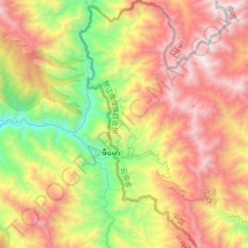
Name: 片马镇 topographic map, elevation, terrain.
Location: 片马镇, 泸水市, 怒江傈僳族自治州, 云南省, 中国 (25.93037 98.57303 26.15121 98.69689)
Average elevation: 8,474 ft
Minimum elevation: 4,229 ft
Maximum elevation: 13,261 ft
片马镇面积约为153平方公里,国境线全长64公里,镇政府海拔1,897米,下辖片马、古浪、岗房、片四河4个村委会和景朗居委会,共有12个村民小组,邮政编码是673200。片马居民有景颇族、傈僳族、白族、汉族等民族;2005年常住人口1,740人,流动暂住人口最高时候4万多人,平常2万多人。
Other topographic maps
Click on a map to view its topography, its elevation and its terrain.