
Franklin County topographic map
Interactive map
Click on the map to display elevation.
About this map
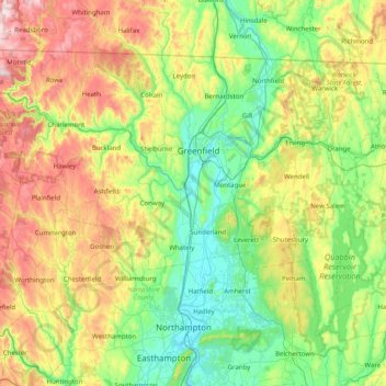
Name: Franklin County topographic map, elevation, terrain.
Location: Franklin County, Massachusetts, United States (42.30328 -73.02371 42.74114 -72.22493)
Average elevation: 886 ft
Minimum elevation: 92 ft
Maximum elevation: 2,644 ft
Other topographic maps
Click on a map to view its topography, its elevation and its terrain.
Boston
United States > Massachusetts > Suffolk County
Boston, Suffolk County, Massachusetts, United States
Average elevation: 82 ft
Martha's Vineyard
United States > Massachusetts > Dukes County > West Tisbury
Martha's Vineyard, West Tisbury, Dukes County, Massachusetts, United States
Average elevation: 10 ft
Amherst
United States > Massachusetts > Hampshire County
Amherst, Hampshire County, Massachusetts, United States
Average elevation: 394 ft
Brighton
United States > Massachusetts > Suffolk County > Boston
Brighton, Boston, Suffolk County, Massachusetts, 02135, United States
Average elevation: 102 ft
Nantucket
Nantucket, Massachusetts, United States
Average elevation: 3 ft
Fitchburg
United States > Massachusetts > Worcester County
Fitchburg, Worcester County, Massachusetts, 01420, United States
Average elevation: 712 ft
Winchester
United States > Massachusetts > Middlesex County
Winchester, Middlesex County, Massachusetts, 01890, United States
Average elevation: 125 ft
Lexington
United States > Massachusetts > Middlesex County
Lexington, Middlesex County, Massachusetts, United States
Average elevation: 203 ft
Cape Cod
United States > Massachusetts > Plymouth County
Cape Cod, Barnstable County, Massachusetts, United States
Average elevation: 7 ft
Provincetown
United States > Massachusetts > Barnstable County
Provincetown, Barnstable County, Massachusetts, 02657, United States
Average elevation: 3 ft
Medford
United States > Massachusetts > Middlesex County
Medford, Middlesex County, Massachusetts, 02155, United States
Average elevation: 75 ft
Somerville
United States > Massachusetts > Middlesex County
Somerville, Middlesex County, Massachusetts, United States
Average elevation: 36 ft
Springfield
United States > Massachusetts > Hampden County > West Springfield
Springfield, Hampden County, Massachusetts, United States
Average elevation: 164 ft
Quincy
United States > Massachusetts > Norfolk County
Quincy, Norfolk County, Massachusetts, United States
Average elevation: 62 ft
Westport
United States > Massachusetts > Bristol County
Westport, Bristol County, Massachusetts, United States
Average elevation: 75 ft
Sandwich
United States > Massachusetts > Barnstable County
Sandwich, Barnstable County, Massachusetts, United States
Average elevation: 79 ft
Taunton
United States > Massachusetts > Bristol County
Taunton, Bristol County, Massachusetts, United States
Average elevation: 72 ft
Germantown
United States > Massachusetts > Norfolk County > Quincy
Germantown, Quincy, Norfolk County, Massachusetts, 02191, United States
Average elevation: 16 ft
Chicopee
United States > Massachusetts > Hampden County
Chicopee, Hampden County, Massachusetts, United States
Average elevation: 220 ft
Framingham
United States > Massachusetts > Middlesex County
Framingham, Middlesex County, Massachusetts, United States
Average elevation: 230 ft
Woburn
United States > Massachusetts > Middlesex County
Woburn, Middlesex County, Massachusetts, 01801, United States
Average elevation: 131 ft
Northampton
United States > Massachusetts > Hampshire County
Northampton, Hampshire County, Massachusetts, United States
Average elevation: 233 ft
Falmouth
United States > Massachusetts > Barnstable County
Falmouth, Barnstable County, Massachusetts, United States
Average elevation: 23 ft
Holyoke
United States > Massachusetts > Hampden County
Holyoke, Hampden County, Massachusetts, 01040, United States
Average elevation: 259 ft
Houghs Neck
United States > Massachusetts > Norfolk County > Quincy
Houghs Neck, Quincy, Norfolk County, Massachusetts, 02191, United States
Average elevation: 7 ft
West Hyannisport
United States > Massachusetts > Barnstable County > Barnstable > Hyannis
West Hyannisport, Hyannis, Barnstable, Barnstable County, Massachusetts, 02672, United States
Average elevation: 16 ft
Lowell
United States > Massachusetts > Middlesex County
Lowell, Middlesex County, Massachusetts, United States
Average elevation: 138 ft
Forest Lake
United States > Massachusetts > Hampden County > Palmer > Whipples
Forest Lake, Whipples, Palmer, Hampden County, Massachusetts, United States
Average elevation: 489 ft
Salem
United States > Massachusetts > Essex County > Salem
Salem, Essex County, Massachusetts, 01970-3980, United States
Average elevation: 52 ft
Worcester
United States > Massachusetts > Worcester County
Worcester, Worcester County, Massachusetts, United States
Average elevation: 610 ft
Hopkinton
United States > Massachusetts > Middlesex County > Hopkinton
Hopkinton, Middlesex County, Massachusetts, 01748, United States
Average elevation: 358 ft
Westfield
United States > Massachusetts > Hampden County
Westfield, Hampden County, Massachusetts, United States
Average elevation: 354 ft
Leominster
United States > Massachusetts > Worcester County
Leominster, Worcester County, Massachusetts, 01453, United States
Average elevation: 545 ft
Andover
United States > Massachusetts > Essex County
Andover, Essex County, Massachusetts, United States
Average elevation: 144 ft
Gloucester
United States > Massachusetts > Essex County > Gloucester
Gloucester, Essex County, Massachusetts, 01930, United States
Average elevation: 49 ft
Rocky Mountain Park
United States > Massachusetts > Franklin County > Greenfield > Greenfield
Rocky Mountain Park, Greenfield, Franklin County, Massachusetts, United States
Average elevation: 223 ft
Byfield
United States > Massachusetts > Essex County > Newbury
Byfield, Newbury, Essex County, Massachusetts, 01883, United States
Average elevation: 66 ft
Haverhill
United States > Massachusetts > Essex County > Haverhill
Haverhill, Essex County, Massachusetts, 01830, United States
Average elevation: 148 ft
Marblehead
United States > Massachusetts > Essex County
Marblehead, Essex County, Massachusetts, 01945, United States
Average elevation: 16 ft
Needham
United States > Massachusetts > Norfolk County
Needham, Norfolk County, Massachusetts, United States
Average elevation: 151 ft
Chelsea
United States > Massachusetts > Suffolk County > Chelsea
Chelsea, Suffolk County, Massachusetts, 02150, United States
Average elevation: 26 ft
Attleboro
United States > Massachusetts > Bristol County > Attleboro
Attleboro, Bristol County, Massachusetts, 02703, United States
Average elevation: 131 ft
Marlborough
United States > Massachusetts > Middlesex County
Marlborough, Middlesex County, Massachusetts, United States
Average elevation: 312 ft
Dartmouth
United States > Massachusetts > Bristol County
Dartmouth, Bristol County, Massachusetts, United States
Average elevation: 69 ft
Orleans
United States > Massachusetts > Barnstable County
Orleans, Barnstable County, Massachusetts, United States
Average elevation: 20 ft
Cherry Valley
United States > Massachusetts > Worcester County > Leicester
Cherry Valley, Leicester, Worcester County, Massachusetts, 01611, United States
Average elevation: 774 ft
Fitchburg
United States > Massachusetts > Worcester County > Fitchburg
Fitchburg, Worcester County, Massachusetts, 01420, United States
Average elevation: 663 ft
Adamsville
United States > Massachusetts > Franklin County > Colrain
Adamsville, Colrain, Franklin County, Massachusetts, 01340, United States
Average elevation: 1,040 ft
Melrose
United States > Massachusetts > Middlesex County
Melrose, Middlesex County, Massachusetts, 02176, United States
Average elevation: 125 ft
Fuller Heights
United States > Massachusetts > Middlesex County > Lexington
Fuller Heights, Lexington, Middlesex County, Massachusetts, 02420, United States
Average elevation: 217 ft