
Make a donation
Gear up for your next adventure:
As an Amazon Associate, this site earns from qualifying purchases at no extra cost to you.
Burqin County topographic map
Click on the map to display elevation.
Make a donation
Gear up for your next adventure:
As an Amazon Associate, this site earns from qualifying purchases at no extra cost to you.
About this map
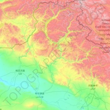
Name: Burqin County topographic map, elevation, terrain.
Location: Burqin County, Altay Prefecture, Xinjiang, 836699, China (47.46143 86.46282 49.17806 88.09104)
Average elevation: 5,259 ft
Minimum elevation: 1,411 ft
Maximum elevation: 14,190 ft
Make a donation
Gear up for your next adventure:
As an Amazon Associate, this site earns from qualifying purchases at no extra cost to you.
Other topographic maps
Click on a map to view its topography, its elevation and its terrain.
Make a donation
Gear up for your next adventure:
As an Amazon Associate, this site earns from qualifying purchases at no extra cost to you.
Make a donation
Gear up for your next adventure:
As an Amazon Associate, this site earns from qualifying purchases at no extra cost to you.
Make a donation
Gear up for your next adventure:
As an Amazon Associate, this site earns from qualifying purchases at no extra cost to you.
Tian Shan
China > Xinjiang > Wensu County
Continuous permafrost is typically found in the Tian Shan starting at the elevation of about 3,500-3,700 m above the sea level. Discontinuous alpine permafrost usually occurs down to 2,700-3,300 m, but in certain locations, due to the peculiarity of the aspect and the microclimate, it can be found at…
Average elevation: 20,000 ft