
Make a donation
Gear up for your next adventure:
As an Amazon Associate, this site earns from qualifying purchases at no extra cost to you.
La Yunga topographic map
Click on the map to display elevation.
Make a donation
Gear up for your next adventure:
As an Amazon Associate, this site earns from qualifying purchases at no extra cost to you.
About this map
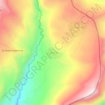
Name: La Yunga topographic map, elevation, terrain.
Location: La Yunga, Santa Rosa, Jaén, Cajamarca, Perú (-5.45810 -78.54967 -5.41810 -78.50967)
Average elevation: 3,579 ft
Minimum elevation: 2,185 ft
Maximum elevation: 4,747 ft
Make a donation
Gear up for your next adventure:
As an Amazon Associate, this site earns from qualifying purchases at no extra cost to you.
Other topographic maps
Click on a map to view its topography, its elevation and its terrain.
Santuario Nacional Tabaconas Namballe
Entre otros, sus atractivos son los raros ecosistemadel páramo andino, numerosas cataratas y un sistema de lagunas poco estudiado: las Arrebiatadas, de belleza paisajística excepcional y reconocidas por sus propiedades medicinales. Dichas lagunas está en una altitud aproximada de 3.200 msnm.
Average elevation: 8,560 ft
Make a donation
Gear up for your next adventure:
As an Amazon Associate, this site earns from qualifying purchases at no extra cost to you.
San Marcos
La provincia sanmarquina comprende altitudes que van desde los 1500 hasta los 4 156 m s. n. m., en ella se puede distinguir tanto valles interandinos como zonas de jalca y puna, y una gran diversidad de microclimas que lo convierten en una zona atractiva y muy especial para los visitantes.
Average elevation: 9,131 ft
Make a donation
Gear up for your next adventure:
As an Amazon Associate, this site earns from qualifying purchases at no extra cost to you.
Make a donation
Gear up for your next adventure:
As an Amazon Associate, this site earns from qualifying purchases at no extra cost to you.
Querocotillo
Tiene una superficie de 697,1 km². Es el distrito más extenso de toda la provincia, o sea que abarca casi la tercera parte del territorio provincial, sin embargo gran parte de la Cordillera Occidental es inhabitable por su clima demasiado frío debido a su altitud sobre los 3,500 m s. n. m.
Average elevation: 6,434 ft
Make a donation
Gear up for your next adventure:
As an Amazon Associate, this site earns from qualifying purchases at no extra cost to you.
Make a donation
Gear up for your next adventure:
As an Amazon Associate, this site earns from qualifying purchases at no extra cost to you.
Make a donation
Gear up for your next adventure:
As an Amazon Associate, this site earns from qualifying purchases at no extra cost to you.
Make a donation
Gear up for your next adventure:
As an Amazon Associate, this site earns from qualifying purchases at no extra cost to you.
Make a donation
Gear up for your next adventure:
As an Amazon Associate, this site earns from qualifying purchases at no extra cost to you.
Bellavista
Entre sus principales festividades destacan: la fiesta patronal en honor a san Isidro Labrador, que se celebra en el mismo distrito en el mes de mayo los días 14, 15 y 16; con un novenario previo que se inicia desde el día 5 de mayo con la participación diaria de diversos sectores institucionales de la…
Average elevation: 2,543 ft
Make a donation
Gear up for your next adventure:
As an Amazon Associate, this site earns from qualifying purchases at no extra cost to you.
Socota
Sócota es uno de los distritos más importantes de la Provincia de Cutervo en la Región Cajamarca república del Perú. Ubicado en un hermoso valle en la que confluyen el río Sucse y el río Socotino, con una altitud a 1750 m s. n. m. y una extensión territorial de 34.82 km, presenta un clima templado lo…
Average elevation: 8,061 ft
Make a donation
Gear up for your next adventure:
As an Amazon Associate, this site earns from qualifying purchases at no extra cost to you.
Make a donation
Gear up for your next adventure:
As an Amazon Associate, this site earns from qualifying purchases at no extra cost to you.
Make a donation
Gear up for your next adventure:
As an Amazon Associate, this site earns from qualifying purchases at no extra cost to you.
Huabal
Se ubica en la parte norte del distrito de Huabal, a una altitud media de 2242 m s. n. m. (metros sobre el nivel del mar), latitud sur: 5° 36′ 23,6″ y 78° 56′ 46″ S (-5.60655303000); longitud oeste: 78° 56′ 36,5″ W (-78.94347539000). El territorio donde se ubica es un territorio quebrado donde…
Average elevation: 5,338 ft
Make a donation
Gear up for your next adventure:
As an Amazon Associate, this site earns from qualifying purchases at no extra cost to you.
Magdalena
El distrito de Magdalena es uno de los doce que conforman la provincia de Cajamarca en el departamento de Cajamarca. Se encuentra rodeado de los cerros Shara, Retablo, Trinchera y Carbunco a una altitud de 1294 m s. n. m. a una distancia de 61 km (hora y media) de la capital departamental. Su territorio está…
Average elevation: 8,510 ft
Make a donation
Gear up for your next adventure:
As an Amazon Associate, this site earns from qualifying purchases at no extra cost to you.
Pedro Gálvez
Comprende altitudes que van desde los 1 500 hasta los 4 156 m s. n. m., en ella se puede distinguir tanto valles interandinos como zonas de jalca y puna y una gran diversidad de microclimas que lo convierten en una zona atractiva y muy especial para los visitantes.
Average elevation: 9,656 ft
Make a donation
Gear up for your next adventure:
As an Amazon Associate, this site earns from qualifying purchases at no extra cost to you.
Encañada
El distrito fue creado mediante Ley del 2 de enero de 1857, en el gobierno de Ramón Castilla. El distrito de la Encañada se encuentra en el departamento y provincia de Cajamarca al norte del Perú. Su territorio se extiende en una franja que corre en dirección sureste-noreste y que alcanza 16,8 km de ancho…
Average elevation: 11,224 ft
Make a donation
Gear up for your next adventure:
As an Amazon Associate, this site earns from qualifying purchases at no extra cost to you.
Make a donation
Gear up for your next adventure:
As an Amazon Associate, this site earns from qualifying purchases at no extra cost to you.
Make a donation
Gear up for your next adventure:
As an Amazon Associate, this site earns from qualifying purchases at no extra cost to you.
Refugio de Vida Silvestre Bosques Nublados de Udima
Average elevation: 7,487 ft
Make a donation
Gear up for your next adventure:
As an Amazon Associate, this site earns from qualifying purchases at no extra cost to you.
Make a donation
Gear up for your next adventure:
As an Amazon Associate, this site earns from qualifying purchases at no extra cost to you.
Make a donation
Gear up for your next adventure:
As an Amazon Associate, this site earns from qualifying purchases at no extra cost to you.
Make a donation
Gear up for your next adventure:
As an Amazon Associate, this site earns from qualifying purchases at no extra cost to you.
Encañada
El distrito fue creado mediante Ley del 2 de enero de 1857, en el gobierno de Ramón Castilla. El distrito de la Encañada se encuentra en el departamento y provincia de Cajamarca al norte del Perú. Su territorio se extiende en una franja que corre en dirección sureste-noreste y que alcanza 16,8 km de ancho…
Average elevation: 11,224 ft
Make a donation
Gear up for your next adventure:
As an Amazon Associate, this site earns from qualifying purchases at no extra cost to you.
Pucará
Ubicado geográficamente en los 06°02’08” de latitud sur, 79°07’32”de longitud a una altitud de 900 m s. n. m. En sus inicios sus límites fueron: por el norte con la quebrada Hualinga que separa al distrito de Colasay; por el este una línea, que partiendo del punto extremo del límite norte se…
Average elevation: 5,646 ft
Make a donation
Gear up for your next adventure:
As an Amazon Associate, this site earns from qualifying purchases at no extra cost to you.
Condebamba
Su capital es la localidad de Cauday, ubicada a una altitud de 2 807 m s. n. m.
Average elevation: 8,169 ft
Condebamba
Su capital es la localidad de Cauday, ubicada a una altitud de 2 807 m s. n. m.
Average elevation: 8,169 ft
Make a donation
Gear up for your next adventure:
As an Amazon Associate, this site earns from qualifying purchases at no extra cost to you.