
Despair Island topographic map
Interactive map
Click on the map to display elevation.
About this map
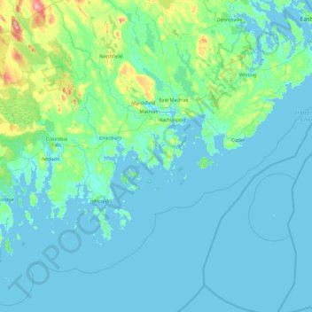
Name: Despair Island topographic map, elevation, terrain.
Location: Despair Island, Washington County, Maine, USA (44.30286 -67.75971 44.94286 -67.11971)
Average elevation: 66 ft
Minimum elevation: -7 ft
Maximum elevation: 666 ft
Other topographic maps
Click on a map to view its topography, its elevation and its terrain.
Biddeford Pool
USA > Maine > Biddeford Pool
Biddeford Pool, York County, Maine, USA
Average elevation: 0 ft
Snowshoe Mountain
Snowshoe Mountain, Piscataquis County, Maine, USA
Average elevation: 1,240 ft
Jordan Harbor
USA > Maine > Gerrishville
Jordan Harbor, Summer Harbor Road, Gerrishville, Hancock County, Maine, 04693, USA
Average elevation: 66 ft
Woodland Center
USA > Maine > Woodland Center
Woodland Center, Aroostook County, Maine, USA
Average elevation: 663 ft
Blackstrap
USA > Maine > Blackstrap
Blackstrap, Cumberland County, Maine, USA
Average elevation: 249 ft
The Mini Muck
The Mini Muck, Miller Street, Belfast, Waldo County, Maine, 04915-9998, USA
Average elevation: 154 ft
Bass Island
USA > Maine > Kennebunkport
Bass Island, Kennebunkport, York County, Maine, USA
Average elevation: 10 ft
Turner Island
USA > Maine > South Portland
Turner Island, South Portland, Cumberland County, Maine, 04112, USA
Average elevation: 118 ft
Timber Island
Timber Island, Biddeford, York County, Maine, USA
Average elevation: 3 ft
Cunningham Mountains
Cunningham Mountains, Penobscot County, Maine, USA
Average elevation: 860 ft
Burnt Coat Harbor Lighthouse
USA > Maine > Swans Island
Burnt Coat Harbor Lighthouse, Harbor Road, Swans Island, Hancock County, Maine, 04685, USA
Average elevation: 16 ft
Lookout Mountain
Lookout Mountain, Penobscot County, Maine, 04455, USA
Average elevation: 525 ft