
Cape Horn South topographic map
Interactive map
Click on the map to display elevation.
About this map
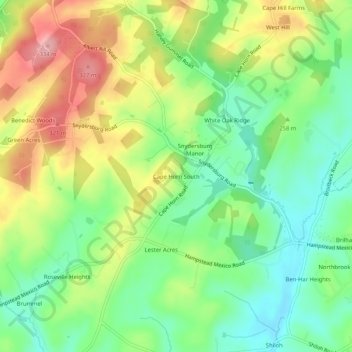
Name: Cape Horn South topographic map, elevation, terrain.
Location: Cape Horn South, Carroll County, Maryland, United States (39.59732 -76.91942 39.63732 -76.87942)
Average elevation: 840 ft
Minimum elevation: 659 ft
Maximum elevation: 1,096 ft
Other topographic maps
Click on a map to view its topography, its elevation and its terrain.
Mount Airy
United States > Maryland > Carroll County
Mount Airy, Carroll County, Maryland, 21771, United States
Average elevation: 725 ft
Bear Branch
United States > Maryland > Carroll County > Brown Heights
Bear Branch, Brown Heights, Carroll County, Maryland, United States
Average elevation: 476 ft
Belle Grove Square
United States > Maryland > Carroll County > Westminster
Belle Grove Square, Westminster, Carroll County, Maryland, 21157, United States
Average elevation: 735 ft
Finksburg
United States > Maryland > Carroll County
Finksburg, Carroll County, Maryland, 21048, United States
Average elevation: 518 ft
Hampstead
United States > Maryland > Carroll County
Hampstead, Carroll County, Maryland, United States
Average elevation: 794 ft
New Windsor
United States > Maryland > Carroll County
New Windsor, Carroll County, Maryland, United States
Average elevation: 505 ft
Eldersburg
United States > Maryland > Carroll County
Eldersburg, Carroll County, Maryland, 21784, United States
Average elevation: 545 ft
Keymar
United States > Maryland > Carroll County
Keymar, Carroll County, Maryland, 21757, United States
Average elevation: 420 ft
Gaither
United States > Maryland > Carroll County
Gaither, Carroll County, Maryland, 21784, United States
Average elevation: 528 ft
Union Bridge
United States > Maryland > Carroll County
Union Bridge, Carroll County, Maryland, United States
Average elevation: 453 ft
Avondale Wildlife Management Area
United States > Maryland > Carroll County > Chapel Heights
Avondale Wildlife Management Area, Chapel Heights, Carroll County, Maryland, United States
Average elevation: 676 ft
Melrose
United States > Maryland > Carroll County
Melrose, Carroll County, Maryland, United States
Average elevation: 860 ft
Heritage
United States > Maryland > Carroll County
Heritage, Carroll County, Maryland, United States
Average elevation: 702 ft
Washington Heights
United States > Maryland > Carroll County > Westminster
Washington Heights, Westminster, Carroll County, Maryland, 21157, United States
Average elevation: 764 ft
Taneytown
United States > Maryland > Carroll County
Taneytown, Carroll County, Maryland, 21787, United States
Average elevation: 502 ft
Millers
United States > Maryland > Carroll County
Millers, Carroll County, Maryland, 21102, United States
Average elevation: 873 ft
Union Mills Homestead Park
United States > Maryland > Carroll County > Union Mills
Union Mills Homestead Park, Union Mills, Carroll County, Maryland, United States
Average elevation: 640 ft
Furnace Hills
United States > Maryland > Carroll County > Westminster
Furnace Hills, Westminster, Carroll County, Maryland, 21157, United States
Average elevation: 692 ft
Marston
United States > Maryland > Carroll County
Marston, Carroll County, Maryland, 21776, United States
Average elevation: 620 ft
Liberty Reservoir
United States > Maryland > Carroll County
Liberty Reservoir, Carroll County, Maryland, United States
Average elevation: 558 ft
Meadow Brook
United States > Maryland > Carroll County > Taneytown
Meadow Brook, Taneytown, Carroll County, Maryland, 21787, United States
Average elevation: 512 ft
Woodbine
United States > Maryland > Carroll County
Woodbine, Carroll County, Maryland, 21797, United States
Average elevation: 597 ft
Mill Stream Hills
United States > Maryland > Carroll County
Mill Stream Hills, Carroll County, Maryland, 21088, United States
Average elevation: 781 ft
Silver Run
United States > Maryland > Carroll County
Silver Run, Carroll County, Maryland, United States
Average elevation: 650 ft
Eldersburg
United States > Maryland > Carroll County > Eldersburg
Eldersburg, Carroll County, Maryland, 21784, United States
Average elevation: 548 ft
Forest Hills
United States > Maryland > Carroll County > Forest Hills
Forest Hills, Carroll County, Maryland, 21157, United States
Average elevation: 745 ft
Manchester
United States > Maryland > Carroll County
Manchester, Carroll County, Maryland, United States
Average elevation: 906 ft
Westminster
United States > Maryland > Carroll County
Westminster, Carroll County, Maryland, United States
Average elevation: 741 ft
Mount Airy
United States > Maryland > Carroll County > Mount Airy > Mount Airy
Mount Airy, Carroll County, Maryland, 21771, United States
Average elevation: 712 ft
Sykesville
United States > Maryland > Carroll County
Sykesville, Carroll County, Maryland, United States
Average elevation: 499 ft
Piney Creek
United States > Maryland > Carroll County
Piney Creek, Carroll County, Maryland, 21787, United States
Average elevation: 499 ft