
Narayani topographic map
Interactive map
Click on the map to display elevation.
About this map
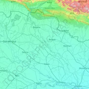
Name: Narayani topographic map, elevation, terrain.
Location: Narayani, Thakrahan, Pashchim Champaran, Bihar, 845466, India (25.61725 83.83386 27.74111 85.20643)
Average elevation: 548 ft
Minimum elevation: 135 ft
Maximum elevation: 9,236 ft
Other topographic maps
Click on a map to view its topography, its elevation and its terrain.
Sonbhadra
India > Bihar > Sonbhadra Banshi Suryapur
Sonbhadra, Sonbhadra Banshi Suryapur, Arwal District, Bihar, 824120, India
Average elevation: 243 ft
Samastipur
Samastipur, Samastipur District, Bihar, 848101, India
Average elevation: 157 ft
Kishanganj
Kishanganj, Madhepura District, Bihar, 852115, India
Average elevation: 128 ft
Pashchim Champāran
Pashchim Champāran, Pashchim Champaran, Bihar, India
Average elevation: 679 ft
Sultanganj
India > Bihar > Sultanganj
Sultanganj, Bhagalpur, Bihar, 813223, India
Average elevation: 125 ft
Patna
India > Bihar > Patna Rural
Patna, Patna Rural, Patna District, Bihar, 800001, India
Average elevation: 167 ft