
Make a donation
Gear up for your next adventure:
As an Amazon Associate, this site earns from qualifying purchases at no extra cost to you.
Tlaxcala topographic map
Click on the map to display elevation.
Make a donation
Gear up for your next adventure:
As an Amazon Associate, this site earns from qualifying purchases at no extra cost to you.
Tlaxcala
Tlaxcala is a land-locked state situated on the Trans-Mexican Volcanic Belt. The average altitude for the state is 2,230 meters above sea level, making it a bit higher than the Valley of Mexico just to the southwest. The western part of the state lies on the central plateau of Mexico while the east is dominated by the Sierra Madre Oriental, home of the 4,461 meter La Malinche volcano. Most of the state is rugged terrain dominated by ridges and deep valleys, along with protruding igneous rock formations. This ruggedness, along with large-scale weather phenomena such as the Intertropical Convergence Zone, gives the state a complex climate. Overall rain patterns for the state are about 400 mm (16 in) in the summer rainy season and 30 mm (1.2 in) in the winter. Locally, however, this varies dramatically between the drier plateaus and valleys and the wetter mountains. Variations in altitude produce sub-climates between semi-tropical to temperate, with frosts likely in the higher elevations during the winter. Temperate forests of pine, fir (Abies religiosa), evergreen oak (Quercus ilex) and junipers (Juniperus communis) dominate the mountain highlands while the flatlands, with their drier climate, are characterized by agaves and prickly pear cactus (Opuntia).
Make a donation
Gear up for your next adventure:
As an Amazon Associate, this site earns from qualifying purchases at no extra cost to you.
About this map
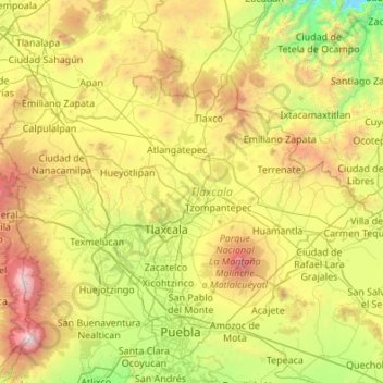
Name: Tlaxcala topographic map, elevation, terrain.
Location: Tlaxcala, Mexico (19.10507 -98.70840 19.72892 -97.62544)
Average elevation: 8,333 ft
Minimum elevation: 4,196 ft
Maximum elevation: 17,480 ft
Make a donation
Gear up for your next adventure:
As an Amazon Associate, this site earns from qualifying purchases at no extra cost to you.
Other topographic maps
Click on a map to view its topography, its elevation and its terrain.
Mexico City
Mexico > Mexico City > Mexico City
Mexico City is located in the Valley of Mexico, sometimes called the Basin of Mexico. This valley is located in the Trans-Mexican Volcanic Belt in the high plateaus of south-central Mexico. It has a minimum altitude of 2,200 meters (7,200 feet) above sea level and is surrounded by mountains and volcanoes that…
Average elevation: 7,615 ft
Monterrey
Mexico > Nuevo León > Monterrey
The city of Monterrey is 540 metres (1,770 ft) above sea level in the northeastern state of Nuevo León. Monterrey translated literally from Spanish to English is "King Mount" or "King Mountain", and folk etymology claims that this refers to the city's topography and the large mountains that surround it…
Average elevation: 2,470 ft
Puerto Vallarta
Mexico > Jalisco > Puerto Vallarta
Fourth: In 1968 the Puerto Vallarta municipality was elevated to City status. The elevation in status reflected interest by Mexican federal and state governments in developing the Puerto Vallarta as an international resort destination. Puerto Vallarta has since also attracted a lively immigrant community from…
Average elevation: 1,004 ft
Tijuana
Mexico > Baja California > Municipio de Tijuana
Housing development in the Tijuana Hills has led to eradication of many seasonal mountain streams. This lack of natural drainage makes places within the city vulnerable to landslides during the rainy season. The varied terrain of Tijuana gives the city elevation extremes that range from sea level to 790 meters…
Average elevation: 463 ft
Make a donation
Gear up for your next adventure:
As an Amazon Associate, this site earns from qualifying purchases at no extra cost to you.
Guadalajara
Mexico > Jalisco > Guadalajara
Under the Köppen climate classification, Guadalajara has a humid subtropical climate (Cwa), a temperate climate that is quite close to a tropical climate, featuring dry warm winters and wet, mildly hot summers. Guadalajara's climate is influenced by its high altitude and the general seasonality of…
Average elevation: 5,157 ft
Ciudad Victoria
Mexico > Tamaulipas > Victoria
Ciudad Victoria has a climate on the border of humid subtropical (Köppen Cfa/Cwa) and hot semi-arid (BSh). Its weather is characterised by short warm winters and long hot to sweltering summers. Temperatures rarely drop below 0 °C (32 °F) — the lowest recorded temperature was −6 °C (21.2 °F) and the…
Average elevation: 1,699 ft
Zapopan
Most of the municipality is flat with another quarter having rolling hills. Altitude varies from 1,500 to 2,000 metres (4,900 to 6,600 ft) above sea level. The main elevations are in the Sierra de la Primavera and include Nejahuete, Tajo and El Chapulin. Superficial water flows mostly in arroyos east to the…
Average elevation: 5,243 ft
Make a donation
Gear up for your next adventure:
As an Amazon Associate, this site earns from qualifying purchases at no extra cost to you.
Culiacán
Culiacán is located in the central region of the State of Sinaloa, forming part of the Northwest of Mexico. The coordinates that correspond to it are 24 ° 48'15 "N (latitude) by 107 ° 25'52" W (West), with an altitude of 54 meters above sea level.
Average elevation: 279 ft
Aguascalientes
Aguascalientes (Spanish pronunciation: [ˌaɣwaskaˈljentes] ; lit. 'Hot Springs'), officially the Free and Sovereign State of Aguascalientes (Spanish: Estado Libre y Soberano de Aguascalientes), is one of the 32 states which comprise the Federal Entities of Mexico. At 22°N and with an average altitude of…
Average elevation: 5,951 ft
Make a donation
Gear up for your next adventure:
As an Amazon Associate, this site earns from qualifying purchases at no extra cost to you.
Saltillo
El Cerro del Pueblo (The People's Hill) and its 4-metre (13 ft) cross overlook the city. The city's elevation makes it colder and windier than the neighboring city of Monterrey. Saltillo lies in the Chihuahuan Desert near the city of Arteaga. The city is flanked by the Zapalinamé mountains, which are part of…
Average elevation: 6,093 ft
San Miguel de Allende
Mexico > Guanajuato > San Miguel de Allende > San Miguel de Allende
Average elevation: 6,657 ft
Make a donation
Gear up for your next adventure:
As an Amazon Associate, this site earns from qualifying purchases at no extra cost to you.
Guanajuato City
Mexico > Guanajuato > Municipio de Guanajuato
Although only one out of every 100 bodies interred in the cemetery became naturally mummified, the concentration of this phenomenon has led to theories about how they have come about. Some believe that they are the result of people who had been buried alive, after mistakenly declared dead. These people,…
Average elevation: 7,159 ft
Make a donation
Gear up for your next adventure:
As an Amazon Associate, this site earns from qualifying purchases at no extra cost to you.
Monterrey
Mexico > Nuevo León > Monterrey
The city of Monterrey is 540 metres (1,770 ft) above sea level in the northeastern state of Nuevo León. Monterrey translated literally from Spanish to English is "King Mount" or "King Mountain", and folk etymology claims that this refers to the city's topography and the large mountains that surround it…
Average elevation: 2,470 ft
Oaxaca City
Mexico > Oaxaca > Oaxaca de Juárez
Oaxaca has a tropical savanna climate (Köppen climate classification Aw), closely bordering on a humid subtropical climate (Cwa), due to its high altitude. During the dry season, temperatures during the day remain warm with an average high of 27.1 °C (80.8 °F) in the coolest month, December, and an average…
Average elevation: 6,030 ft
Make a donation
Gear up for your next adventure:
As an Amazon Associate, this site earns from qualifying purchases at no extra cost to you.
Saltillo
El Cerro del Pueblo (The People's Hill) and its 4-metre (13 ft) cross overlook the city. The city's elevation makes it colder and windier than the neighboring city of Monterrey. Saltillo lies in the Chihuahuan Desert near the city of Arteaga. The city is flanked by the Zapalinamé mountains, which are part of…
Average elevation: 6,093 ft
Zamora
The city of Zamora is an important economic center in the state and the most significant population center between the cities of Morelia and Guadalajara. The city is located on the Tarascan Plateau in the northwestern part of the state, at an elevation of 1,567 m (5,141 ft) above sea level. Zamora is…
Average elevation: 5,899 ft
Make a donation
Gear up for your next adventure:
As an Amazon Associate, this site earns from qualifying purchases at no extra cost to you.
San Luis Potosí City
Mexico > San Luis Potosi > Municipio de San Luis Potosí
San Luis Potosí, commonly called SLP or simply San Luis, is the capital and the most populous city of the Mexican state of San Luis Potosí. It is the municipal seat of the surrounding municipality of San Luis Potosí. The city lies at an elevation of 1,864 metres (6,115 feet). It has an estimated population…
Average elevation: 6,575 ft
Make a donation
Gear up for your next adventure:
As an Amazon Associate, this site earns from qualifying purchases at no extra cost to you.
Morelia
Under the Köppen climate classification, Morelia has a subtropical highland climate (abbreviated Cwb on climate maps), with warm-to-hot days and cool nights year round due to its high elevation. Most precipitation falls during the summer monsoon season from June to September. Average monthly temperatures are…
Average elevation: 6,795 ft
Cuernavaca
Mexico > Morelos > Cuernavaca
The city is located in a tropical region, but its temperature is fairly constant at 21–26 °C (70–79 °F). It is located on the southern slope of the Sierra de Chichinautzin mountains. In the morning, warm air flows up the mountains from the valley below and in the late afternoon, cooler air flows down…
Average elevation: 5,978 ft
Make a donation
Gear up for your next adventure:
As an Amazon Associate, this site earns from qualifying purchases at no extra cost to you.
Popocatépetl
Mexico > Puebla > Tochimilco
According to paleomagnetic studies, the volcano is about 730,000 years old. It is cone shaped with a diameter of 25 km (16 mi) at its base, with a peak elevation of 5,450 m (17,880 ft). The crater is elliptical with an orientation northeast-southwest. The walls of the crater vary from 600 to 840 m (1,970 to…
Average elevation: 15,771 ft
Zihuatanejo
Mexico > Guerrero > Zihuatanejo de Azueta
The town of Zihuatanejo is the seat of the municipality of Zihuatanejo de Azueta and as such is the governmental authority for approximately 416 communities, with a total population of 104,609 as of 2005, and an area of 1,921.5 km2 (741.9 sq mi). There are small indigenous communities in the municipality which…
Average elevation: 338 ft
Make a donation
Gear up for your next adventure:
As an Amazon Associate, this site earns from qualifying purchases at no extra cost to you.
Ciudad Juárez
Due to its location in the Chihuahuan Desert and high altitude, Ciudad Juárez has a cold desert climate (Köppen: BWk). Seasons are distinct, with hot summers, mild springs and autumns, and cold winters. Summer average high is 35 °C (95 °F) with lows of 21 °C (70 °F). Winter highs average 14 °C (57 °F)…
Average elevation: 3,970 ft
Isthmus of Tehuantepec
At its narrowest point, the isthmus is 200 km (124 mi) across from gulf to gulf, or 192 km (119 mi) to the head of Laguna Superior on the Pacific coast. The Sierra Madre del Sur mountain range breaks down at this point into a broad, plateau-like ridge, whose elevation, at the highest point reached by the…
Average elevation: 909 ft
Make a donation
Gear up for your next adventure:
As an Amazon Associate, this site earns from qualifying purchases at no extra cost to you.
Rosarito
Mexico > Baja California > Municipio de Playas de Rosarito
Playas de Rosarito lies on the coast of the Pacific Ocean on the North Baja California Peninsula. The city is positioned between the foothills of the Peninsular Ranges and the ocean. It maintains a relatively uniform topography and displays few variances in terrain.
Average elevation: 338 ft
San Francisco de la Sierra
Mexico > Baja California Sur > Municipio de Mulegé
Average elevation: 3,802 ft
Cabo San Lucas
Mexico > Baja California Sur > Los Cabos Municipality > Cabo San Lucas
Average elevation: 7 ft
Make a donation
Gear up for your next adventure:
As an Amazon Associate, this site earns from qualifying purchases at no extra cost to you.
San Luis Potosí City
Mexico > San Luis Potosi > Municipio de San Luis Potosí
San Luis Potosí, commonly referred to as San Luis, or by its initials SLP (Otomi: Nmiñ'u), is the capital and the most populous city of the Mexican state of San Luis Potosí. It is the municipal seat of the surrounding municipality of San Luis Potosí. The city lies at an elevation of 1,864 metres (6,115…
Average elevation: 6,575 ft
Acapulco
Mexico > Guerrero > Acapulco de Juárez
The city, located on the Pacific coast of Mexico in the state of Guerrero, is classified as one of the state's seven regions, dividing the rest of the Guerrero coast into the Costa Grande and the Costa Chica. Forty percent of the municipality is mountainous terrain; another forty percent is semi-flat; and the…
Average elevation: 325 ft
Morelia
Under the Köppen climate classification, Morelia has a subtropical highland climate (abbreviated Cwb on climate maps), with warm-to-hot days and cool nights year round due to its high elevation. Most precipitation falls during the summer monsoon season from June to September. Average monthly temperatures are…
Average elevation: 6,795 ft
Make a donation
Gear up for your next adventure:
As an Amazon Associate, this site earns from qualifying purchases at no extra cost to you.
Xochimilco
Much of the borough's land is former lakebed. Its main elevations include Xochitepec and Tlacualleli mountains along with two volcanoes named Teutli and Tzompol. It contains two natural rivers called Santiago and Tepapantla along with the various canals, which is what is left of the lake. The elevated areas of…
Average elevation: 7,352 ft
La Paz
Mexico > Baja California Sur > Municipio de La Paz
The city, in west-central Bolivia 68 km (42 mi) southeast of Lake Titicaca, is set in a canyon created by the Choqueyapu River. It is in a bowl-like depression, part of the Amazon basin, surrounded by the high mountains of the Altiplano. Overlooking the city is the towering, triple-peaked Illimani. Its peaks…
Average elevation: 374 ft
Make a donation
Gear up for your next adventure:
As an Amazon Associate, this site earns from qualifying purchases at no extra cost to you.
Toluca
Mexico > State of Mexico > Toluca
Toluca is located at 2600 meters above sea level, being the highest capital city in Mexico and North America, which makes it temperate throughout the year with average temperatures ranging between 6 and 25 degrees Celsius during spring and summer, and from −5 to 20 degrees Celsius in winter. Its climate is…
Average elevation: 8,953 ft
Ajijic
The Chapala Lake basin has a year-round average temperature of about 19 °C (66 °F). Due to Ajijic's tropical latitude and relatively high elevation, it is seldom unpleasantly hot or humid. The rainy season begins in June and lasts until October. The average rainfall is 793 millimetres (31.2 in). Even during…
Average elevation: 5,702 ft
Make a donation
Gear up for your next adventure:
As an Amazon Associate, this site earns from qualifying purchases at no extra cost to you.
Tijuana
Mexico > Baja California > Municipio de Tijuana
Housing development in the Tijuana Hills has led to eradication of many seasonal mountain streams. This lack of natural drainage makes places within the city vulnerable to landslides during the rainy season. The varied terrain of Tijuana gives the city elevation extremes that range from sea level to 790 meters…
Average elevation: 463 ft
Make a donation
Gear up for your next adventure:
As an Amazon Associate, this site earns from qualifying purchases at no extra cost to you.
Tequila
Tequila is one of the 124 municipalities of Jalisco, located just west of the center of the state. Its territory extends for 1689.11km2, with elevations that vary between 700 and 2,900 meters above sea level. The municipality borders with the main metropolitan region of Guadalajara to the east (Zapopan), and…
Average elevation: 4,157 ft
Make a donation
Gear up for your next adventure:
As an Amazon Associate, this site earns from qualifying purchases at no extra cost to you.
Monterrey
Mexico > Nuevo León > Monterrey
The city of Monterrey is 540 metres (1,770 ft) above sea level in the northeastern state of Nuevo León. Monterrey translated from Spanish to English is "King Mount" or "King mountain", which refers to the city's topography and the large mountains that surround it. The Santa Catarina River—dry most of the…
Average elevation: 2,470 ft
Colonia el Pajarito
Mexico > Oaxaca > Zimatlán de Álvarez > Zimatlán de Álvarez
Average elevation: 4,984 ft
Make a donation
Gear up for your next adventure:
As an Amazon Associate, this site earns from qualifying purchases at no extra cost to you.
Chihuahua City
Mexico > Chihuahua > Municipio de Chihuahua
Chihuahua lies on the western side of the Chihuahuan Desert ecoregion and as such has a hot semi-arid climate (Köppen climate classification BSh). However, it is not as hot as most of the lower elevated portions of the desert to the east owing to an altitude of almost 1,500 metres (4,900 feet) above sea level.
Average elevation: 5,102 ft
Make a donation
Gear up for your next adventure:
As an Amazon Associate, this site earns from qualifying purchases at no extra cost to you.
Los Algodones
Mexico > Baja California > Municipio de Mexicali
The town is at an elevation of 110 feet/33.5 m above mean sea level.
Average elevation: 167 ft
Make a donation
Gear up for your next adventure:
As an Amazon Associate, this site earns from qualifying purchases at no extra cost to you.
Ciudad Obregón
The city is located on the parallel 27–29' north latitude and the meridian 109-59' west longitude. With an altitude above sea level of 40.8 m (134 ft) in the city center.
Average elevation: 194 ft
Make a donation
Gear up for your next adventure:
As an Amazon Associate, this site earns from qualifying purchases at no extra cost to you.
Make a donation
Gear up for your next adventure:
As an Amazon Associate, this site earns from qualifying purchases at no extra cost to you.
Toluca
Mexico > State of Mexico > Toluca
The Lerma River flows from Lake Almoloya del Río through the center of the municipality towards the west, flowing into Lake Chapala. From this point westward the river takes the name of Río Grande de Santiago. And it goes from this lake to the Pacific Ocean in the state of Nayarit. The river is about 1,180…
Average elevation: 8,953 ft
Guadalajara
Mexico > Jalisco > Guadalajara
Under the Köppen climate classification, Guadalajara has a humid subtropical climate (Cwa), a temperate climate that is quite close to a tropical climate, featuring dry warm winters and wet, mildly hot summers. Guadalajara's climate is influenced by its high altitude and the general seasonality of…
Average elevation: 5,157 ft
Make a donation
Gear up for your next adventure:
As an Amazon Associate, this site earns from qualifying purchases at no extra cost to you.
Make a donation
Gear up for your next adventure:
As an Amazon Associate, this site earns from qualifying purchases at no extra cost to you.
Popocatépetl
Mexico > State of Mexico > Atlautla
According to paleomagnetic studies, the volcano is about 730,000 years old. It is cone shaped with a diameter of 25 km (16 mi) at its base, with a peak elevation of 5,450 m (17,880 ft). The crater is elliptical with an orientation northeast-southwest. The walls of the crater vary from 600 to 840 m (1,970 to…
Average elevation: 15,781 ft
Ciudad Juárez
Due to its location in the Chihuahuan Desert and high altitude, Ciudad Juárez has a cold desert climate (Köppen: BWk). Seasons are distinct, with hot summers, mild springs and autumns, and cold winters. Summer average high is 35 °C (95 °F) with lows of 21 °C (70 °F). Winter highs average 14 °C (57 °F)…
Average elevation: 4,029 ft
Make a donation
Gear up for your next adventure:
As an Amazon Associate, this site earns from qualifying purchases at no extra cost to you.