
Hopkins County topographic map
Interactive map
Click on the map to display elevation.
About this map
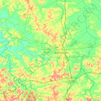
Name: Hopkins County topographic map, elevation, terrain.
Location: Hopkins County, Kentucky, United States (37.10516 -87.85183 37.57006 -87.29575)
Average elevation: 440 ft
Minimum elevation: 328 ft
Maximum elevation: 719 ft
The topography ranges from flatlands along the broad river valleys of the Pond River, Tradewater River, and Green River, to hilly and rolling land in the southern and central parts of the county. Coal mines operate in the southern part of Hopkins County and agriculture is a mainstay in the northern part. Major crops are soybeans, corn, and tobacco. Along with coal, resources include oil and natural gas.
Other topographic maps
Click on a map to view its topography, its elevation and its terrain.
Bowling Green
United States > Kentucky > Warren County
Bowling Green, Warren County, Kentucky, 42101, United States
Average elevation: 554 ft
Louisville
United States > Kentucky > Jefferson County
Louisville, Jefferson County, Kentucky, United States
Average elevation: 617 ft
Owensboro
United States > Kentucky > Daviess County
Owensboro, Daviess County, Kentucky, United States
Average elevation: 404 ft
Elliott County
Elliott County, Kentucky, United States
Average elevation: 912 ft
Hickman County
Hickman County, Kentucky, United States
Average elevation: 381 ft
Nicholas County
Nicholas County, Kentucky, United States
Average elevation: 856 ft
Rockcastle County
Rockcastle County, Kentucky, United States
Average elevation: 1,142 ft
Hindman
United States > Kentucky > Knott County
Hindman, Knott County, Kentucky, United States
Average elevation: 1,273 ft
Frankfort
United States > Kentucky > Franklin County
Frankfort, Franklin County, Kentucky, United States
Average elevation: 709 ft
Paducah
United States > Kentucky > McCracken County
Paducah, McCracken County, Kentucky, United States
Average elevation: 354 ft
Kentucky River
Kentucky River, Kentucky, United States
Average elevation: 853 ft
Somerset
United States > Kentucky > Pulaski County
Somerset, Pulaski County, Kentucky, 42503, United States
Average elevation: 968 ft
Walker
United States > Kentucky > Knox County
Walker, Knox County, Kentucky, 40997, United States
Average elevation: 1,322 ft
Little Pilot Knob
United States > Kentucky > Wayne County
Little Pilot Knob, Wayne County, Kentucky, United States
Average elevation: 1,227 ft
Lexington
United States > Kentucky > Lexington
Lexington, Fayette County, Kentucky, 40508, United States
Average elevation: 935 ft
Monticello
United States > Kentucky > Wayne County
Monticello, Wayne County, Kentucky, 42633, United States
Average elevation: 997 ft
Balltown
United States > Kentucky > Whitley County > Williamsburg
Balltown, Williamsburg, Whitley County, Kentucky, 40769, United States
Average elevation: 1,089 ft
Shepherdsville
United States > Kentucky > Bullitt County
Shepherdsville, Bullitt County, Kentucky, United States
Average elevation: 486 ft
Danville
United States > Kentucky > Boyle County
Danville, Boyle County, Kentucky, United States
Average elevation: 951 ft
Newport
United States > Kentucky > Campbell County
Newport, Campbell County, Kentucky, 41071, United States
Average elevation: 568 ft
Paint Lick
United States > Kentucky > Garrard County
Paint Lick, Garrard County, Kentucky, 40461, United States
Average elevation: 892 ft
Pathfork
United States > Kentucky > Harlan County
Pathfork, Harlan County, Kentucky, 40863, United States
Average elevation: 1,752 ft
Lenarue
United States > Kentucky > Harlan County
Lenarue, Harlan County, Kentucky, 40818, United States
Average elevation: 1,703 ft
Fayette County
Fayette County, Kentucky, United States
Average elevation: 925 ft
Hustonville
United States > Kentucky > Lincoln County
Hustonville, Lincoln County, Kentucky, United States
Average elevation: 1,037 ft
Lone Star
United States > Kentucky > Hart County
Lone Star, Hart County, Kentucky, 42713, United States
Average elevation: 748 ft
Sonora
United States > Kentucky > Hardin County
Sonora, Hardin County, Kentucky, United States
Average elevation: 725 ft
Load
United States > Kentucky > Greenup County
Load, Greenup County, Kentucky, United States
Average elevation: 728 ft
Bardo
United States > Kentucky > Harlan County
Bardo, Harlan County, Kentucky, 40830, United States
Average elevation: 2,080 ft
Holmes Mill
United States > Kentucky > Harlan County
Holmes Mill, Harlan County, Kentucky, 40843, United States
Average elevation: 2,487 ft
Pansy
United States > Kentucky > Harlan County
Pansy, Harlan County, Kentucky, 40830, United States
Average elevation: 1,975 ft
Boyd
United States > Kentucky > Harrison County
Boyd, Harrison County, Kentucky, 41003, United States
Average elevation: 702 ft
Uno
United States > Kentucky > Hart County
Uno, Hart County, Kentucky, United States
Average elevation: 659 ft
Walnut Hill
United States > Kentucky > Fayette County > Lexington
Walnut Hill, Lexington, Fayette County, Kentucky, 40509, United States
Average elevation: 1,020 ft
Lexington
United States > Kentucky > Fayette County
Lexington, Fayette County, Kentucky, United States
Average elevation: 922 ft
Sparrow
United States > Kentucky > Anderson County
Sparrow, Anderson County, Kentucky, United States
Average elevation: 755 ft
Putney
United States > Kentucky > Harlan County
Putney, Harlan County, Kentucky, 40865, United States
Average elevation: 1,972 ft
Hardyville
United States > Kentucky > Hart County
Hardyville, Hart County, Kentucky, United States
Average elevation: 696 ft
Inez
United States > Kentucky > Martin County
Inez, Martin County, Kentucky, 41224, United States
Average elevation: 830 ft
Elkhorn City
United States > Kentucky > Pike County
Elkhorn City, Pike County, Kentucky, United States
Average elevation: 1,194 ft
Alva
United States > Kentucky > Harlan County
Alva, Harlan County, Kentucky, 40863, United States
Average elevation: 2,139 ft
Yancey
United States > Kentucky > Harlan County
Yancey, Harlan County, Kentucky, 40830, United States
Average elevation: 2,136 ft
Leesburg
United States > Kentucky > Harrison County
Leesburg, Harrison County, Kentucky, United States
Average elevation: 919 ft
Jonesville
United States > Kentucky > Hart County
Jonesville, Hart County, Kentucky, 42757, United States
Average elevation: 791 ft
Frost
United States > Kentucky > Greenup County
Frost, Greenup County, Kentucky, 41175, United States
Average elevation: 591 ft
Land Between the Lakes National Recreation Area
United States > Kentucky > Trigg County
Land Between the Lakes National Recreation Area, Trigg County, Kentucky, United States
Average elevation: 479 ft
Fresh Meadows
United States > Kentucky > Harlan County
Fresh Meadows, Harlan County, Kentucky, 40824, United States
Average elevation: 1,516 ft
Pine Mountain
United States > Kentucky > Harlan County
Pine Mountain, Harlan County, Kentucky, United States
Average elevation: 1,759 ft
Kenvir
United States > Kentucky > Harlan County
Kenvir, Harlan County, Kentucky, 40847, United States
Average elevation: 2,106 ft