Geolocate

Kentucky River topographic map

Click on the map to display elevation.

About this map

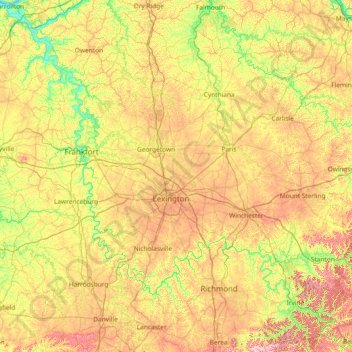
Name: Kentucky River topographic map, elevation, terrain.

Location: Kentucky River, Kentucky, United States (37.55058 -85.18939 38.68712 -83.71092)

Average elevation: 853 ft

Minimum elevation: 436 ft

Maximum elevation: 1,581 ft

Kentucky trails, hiking, mountain biking, running and outdoor activities

Other topographic maps

Click on a map to view its topography, its elevation and its terrain.

Lexington

United States > Kentucky > Lexington

Average elevation: 935 ft

Elk Lake

United States > Kentucky

Average elevation: 827 ft

Licking River

United States > Kentucky

Average elevation: 522 ft

Littleton

United States > Kentucky > Clay County

Average elevation: 1,033 ft

Barren River

United States > Kentucky > Warren County

Average elevation: 577 ft

Richland

United States > Kentucky > Hopkins County

Average elevation: 427 ft

Ibex

United States > Kentucky > Elliott County

Average elevation: 817 ft

Totz

United States > Kentucky > Harlan County

Average elevation: 2,093 ft

Kings Mountain

United States > Kentucky > Lincoln County

Average elevation: 1,230 ft

Pleasant Valley

United States > Kentucky > Pike County > Pikeville

Average elevation: 1,033 ft

Bledsoe

United States > Kentucky > Harlan County

Average elevation: 1,982 ft

Newby

United States > Kentucky > Madison County

Average elevation: 892 ft

Slabtown

United States > Kentucky > Henry County

Average elevation: 719 ft

Wesleyan Park

United States > Kentucky > Clark County > Winchester

Average elevation: 974 ft

Canton

United States > Kentucky > Trigg County

Average elevation: 400 ft

Redhouse

United States > Kentucky > Madison County

Average elevation: 814 ft

Cane Valley

United States > Kentucky > Adair County

Average elevation: 837 ft

Hopewell

United States > Kentucky > Laurel County

Average elevation: 1,175 ft

Creech

United States > Kentucky > Harlan County

Average elevation: 2,169 ft

Kelat

United States > Kentucky > Harrison County

Average elevation: 840 ft

Gainesway

United States > Kentucky > Fayette County > Lexington

Average elevation: 988 ft

Plano

United States > Kentucky > Warren County

Average elevation: 597 ft

Lost Creek

United States > Kentucky > Breathitt County

Average elevation: 1,001 ft

Altro

United States > Kentucky > Breathitt County

Average elevation: 1,043 ft

Vancleve

United States > Kentucky > Breathitt County

Average elevation: 965 ft

Whick

United States > Kentucky > Breathitt County

Average elevation: 1,030 ft

Parksville

United States > Kentucky > Boyle County

Average elevation: 1,096 ft

Cannonsburg

United States > Kentucky > Boyd County

Average elevation: 712 ft

Ironville

United States > Kentucky > Boyd County

Average elevation: 702 ft

Stoney Fork

United States > Kentucky > Bell County

Average elevation: 1,703 ft

Miracle

United States > Kentucky > Bell County

Average elevation: 1,355 ft

Kettle Island

United States > Kentucky > Bell County

Average elevation: 1,539 ft

Fourmile

United States > Kentucky > Bell County

Average elevation: 1,332 ft

Calvin

United States > Kentucky > Bell County

Average elevation: 1,296 ft

Beverly

United States > Kentucky > Bell County

Average elevation: 1,726 ft

Arjay

United States > Kentucky > Bell County

Average elevation: 1,522 ft

Olympia

United States > Kentucky > Bath County

Average elevation: 814 ft

Etoile

United States > Kentucky > Barren County

Average elevation: 807 ft

Eighty Eight

United States > Kentucky > Barren County

Average elevation: 791 ft

Hiseville

United States > Kentucky > Barren County

Average elevation: 725 ft

Dubre

United States > Kentucky > Cumberland County

Average elevation: 735 ft

Marrowbone

United States > Kentucky > Cumberland County

Average elevation: 696 ft

Alpha

United States > Kentucky > Clinton County

Average elevation: 1,024 ft

Sextons Creek

United States > Kentucky > Clay County

Average elevation: 1,020 ft

Big Creek

United States > Kentucky > Clay County

Average elevation: 1,161 ft

Bobs Fork

United States > Kentucky > Leslie County

Average elevation: 1,230 ft

Fall Rock

United States > Kentucky > Clay County

Average elevation: 1,129 ft

Ford

United States > Kentucky > Clark County

Average elevation: 771 ft

Gordon Lick Knob

United States > Kentucky > Casey County

Average elevation: 1,168 ft

Windsor

United States > Kentucky > Casey County

Average elevation: 1,102 ft

Middleburg

United States > Kentucky > Casey County

Average elevation: 942 ft

Dunnville

United States > Kentucky > Casey County

Average elevation: 807 ft

Bethelridge

United States > Kentucky > Casey County

Average elevation: 1,129 ft

Hitchins

United States > Kentucky > Carter County

Average elevation: 705 ft

Denton

United States > Kentucky > Carter County

Average elevation: 761 ft

Culver

United States > Kentucky > Elliott County

Average elevation: 889 ft

Stark

United States > Kentucky > Elliott County

Average elevation: 935 ft

Sweet Lick Knob

United States > Kentucky > Estill County

Average elevation: 686 ft

Teaberry

United States > Kentucky > Floyd County

Average elevation: 1,296 ft

Melvin

United States > Kentucky > Floyd County

Average elevation: 1,411 ft

Printer

United States > Kentucky > Floyd County

Average elevation: 971 ft

Stanville

United States > Kentucky > Floyd County

Average elevation: 922 ft

Hueysville

United States > Kentucky > Floyd County

Average elevation: 945 ft

Ivel

United States > Kentucky > Floyd County

Average elevation: 925 ft

Hi Hat

United States > Kentucky > Floyd County

Average elevation: 1,257 ft

Garrett

United States > Kentucky > Floyd County

Average elevation: 958 ft

Drift

United States > Kentucky > Floyd County

Average elevation: 1,024 ft

David

United States > Kentucky > Floyd County

Average elevation: 1,070 ft

Dana

United States > Kentucky > Floyd County

Average elevation: 1,056 ft

Bypro

United States > Kentucky > Floyd County

Average elevation: 1,309 ft

Beaver

United States > Kentucky > Floyd County

Average elevation: 1,453 ft

Banner

United States > Kentucky > Floyd County

Average elevation: 912 ft

Dwale

United States > Kentucky > Floyd County

Average elevation: 886 ft

Betsy Layne

United States > Kentucky > Floyd County

Average elevation: 886 ft

Elizaville

United States > Kentucky > Fleming County

Average elevation: 902 ft

Chevy Chase

United States > Kentucky > Fayette County > Lexington

Average elevation: 1,017 ft

Gratz Park

United States > Kentucky > Fayette County > Lexington

Average elevation: 981 ft

Bryan Station

United States > Kentucky > Fayette County > Lexington

Average elevation: 948 ft

Nevada

United States > Kentucky > Mercer County

Average elevation: 879 ft

Woodsonville

United States > Kentucky > Hart County

Average elevation: 600 ft

Uno

United States > Kentucky > Hart County

Average elevation: 659 ft

Northtown

United States > Kentucky > Hart County

Average elevation: 738 ft

Lone Star

United States > Kentucky > Hart County

Average elevation: 748 ft

Jonesville

United States > Kentucky > Hart County

Average elevation: 791 ft

Hammonville

United States > Kentucky > Hart County

Average elevation: 761 ft

Canmer

United States > Kentucky > Hart County

Average elevation: 607 ft

Big Windy

United States > Kentucky > Hart County

Average elevation: 676 ft

Bee

United States > Kentucky > Hart County

Average elevation: 755 ft

Hardyville

United States > Kentucky > Hart County

Average elevation: 696 ft

Lair

United States > Kentucky > Harrison County

Average elevation: 807 ft

Lees Lick

United States > Kentucky > Harrison County

Average elevation: 869 ft

Leesburg

United States > Kentucky > Harrison County

Average elevation: 919 ft

Oddville

United States > Kentucky > Harrison County

Average elevation: 846 ft

Robinson

United States > Kentucky > Harrison County

Average elevation: 725 ft

Rutland

United States > Kentucky > Harrison County

Average elevation: 840 ft

Connersville

United States > Kentucky > Harrison County

Average elevation: 840 ft

Colville

United States > Kentucky > Harrison County

Average elevation: 873 ft

Colemansville

United States > Kentucky > Harrison County

Average elevation: 712 ft

Claysville

United States > Kentucky > Harrison County

Average elevation: 686 ft

Gear up for your next adventure:

🎒Trail Energy Bars - High‑calorie bars for hiking energy
🪶Thermal Camp Blanket - Extra warmth for cold nights
🔊Portable Camp Speaker - Music and alerts at camp
🥄Camping Utensil Set - Lightweight utensils for outdoor meals
🔌USB Car Charger - Car charger for on‑the‑go power needs

As an Amazon Associate, this site earns from qualifying purchases at no extra cost to you.