
Fellbach topographic map
Click on the map to display elevation.
Fellbach
Die B 14 (Schwäbisch Hall–Stuttgart) führte durch die Stadt bis 1992 der 1600 m langen Kappelbergtunnel eröffnet wurde, der den Durchgangsverkehr um das südliche Stadtgebiet herumleitet. Da ein Nordostring Stuttgart auch aufgrund von Widerstand aus Fellbach bisher nicht gebaut wurde, beginnt die B 29 (Waiblingen/Fellbach–Schwäbisch Gmünd–Aalen) am östlichen Ortsrand von Fellbach am Teiler mit der B14. Außerdem wird Fellbach von einem zweiten Tunnel untertunnelt, dem 1997 eröffneten Fellbacher Stadttunnel (siehe auch unten unter Bauwerke). Dieser Tunnel leitet den Verkehr der alten B 14, der nicht durch den Kappelbergtunnel aufgenommen wurde, unter der Stadt hindurch in Richtung Stuttgart-Bad Cannstatt/Bereich Fellbach Höhenstraße bzw. in Richtung Waiblingen/Bereich Fellbach Bühlstraße.
About this map
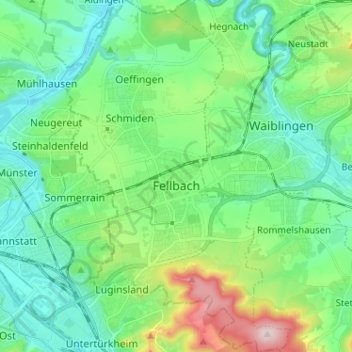
Name: Fellbach topographic map, elevation, terrain.
Location: Fellbach, Rems-Murr-Kreis, Baden-Württemberg, Deutschland (48.77829 9.23717 48.86275 9.31974)
Average elevation: 925 ft
Minimum elevation: 676 ft
Maximum elevation: 1,677 ft
Other topographic maps
Click on a map to view its topography, its elevation and its terrain.
Archäologischer Park Ostkastell
Deutschland > Baden-Württemberg > Rems-Murr-Kreis > Welzheim
Average elevation: 1,667 ft
Oberer Reichenberg
Deutschland > Baden-Württemberg > Rems-Murr-Kreis > Oppenweiler
Average elevation: 1,109 ft
Burkhardshof
Deutschland > Baden-Württemberg > Rems-Murr-Kreis > Winnenden
Average elevation: 1,109 ft
See
Deutschland > Baden-Württemberg > Rems-Murr-Kreis > Oppenweiler > Oberer Reichenberg
Average elevation: 1,030 ft
Buoch
Deutschland > Baden-Württemberg > Rems-Murr-Kreis > Remshalden
Remshalden liegt rund 25 Kilometer nordöstlich von Stuttgart im Remstal entlang der Bundesstraße 29. Das Gemeindegebiet erstreckt sich über eine Höhenlage von 237 bis 519 Metern.
Average elevation: 1,250 ft
Ebni
Deutschland > Baden-Württemberg > Rems-Murr-Kreis > Kaisersbach
In der Römerzeit war das Gebiet des heutigen Ebni noch wenig erschlossen und von dichtem Wald bedeckt. Um 161 n. Chr. drangen römische Truppen vom Neckarbecken kommend in das Gebiet vor und errichteten den obergermanisch-rätischen Limes, der etwa einen Kilometer östlich von Ebni verlief. Damit gehörte das…
Average elevation: 1,650 ft
Großaspach
Deutschland > Baden-Württemberg > Rems-Murr-Kreis > Aspach
Aspach hat Anteil an den Naturräumen Schwäbisch-Fränkische Waldberge und Neckarbecken. Es liegt am Südrand der Löwensteiner Berge in 254 bis 516 Meter Höhe. Westlich des Ortsteils Kleinaspach liegt der Hardtwald.
Average elevation: 961 ft
Rietenau
Deutschland > Baden-Württemberg > Rems-Murr-Kreis > Aspach > Rietenau
Average elevation: 1,086 ft
Grunbach
Deutschland > Baden-Württemberg > Rems-Murr-Kreis > Remshalden > Grunbach
Average elevation: 1,073 ft
Steinreinach
Deutschland > Baden-Württemberg > Rems-Murr-Kreis > Steinreinach
Average elevation: 1,056 ft
Wildgehege Plattenwald
Deutschland > Baden-Württemberg > Rems-Murr-Kreis > Backnang > Strümpfelbach
Average elevation: 942 ft
Schloss Ebersberg
Deutschland > Baden-Württemberg > Rems-Murr-Kreis > Auenwald > Ebersberg
Average elevation: 1,286 ft
Vordermurrhärle
Deutschland > Baden-Württemberg > Rems-Murr-Kreis > Murrhardt
Average elevation: 1,299 ft
Schiffrain
Deutschland > Baden-Württemberg > Rems-Murr-Kreis > Oppenweiler
Average elevation: 1,207 ft
Wilhelmsheim
Deutschland > Baden-Württemberg > Rems-Murr-Kreis > Oppenweiler
Average elevation: 1,211 ft
Gaisberg
Deutschland > Baden-Württemberg > Rems-Murr-Kreis > Kirchberg an der Murr
Average elevation: 912 ft
Alter Hohlweg
Deutschland > Baden-Württemberg > Rems-Murr-Kreis > Backnang
Average elevation: 1,096 ft
Schlichenweiler
Deutschland > Baden-Württemberg > Rems-Murr-Kreis > Sechselberg
Average elevation: 1,430 ft
Necklinsberg
Deutschland > Baden-Württemberg > Rems-Murr-Kreis > Rudersberg
Average elevation: 1,181 ft
Däfern
Deutschland > Baden-Württemberg > Rems-Murr-Kreis > Auenwald > Hohnweiler
Average elevation: 1,293 ft
Frühmeßhof
Deutschland > Baden-Württemberg > Rems-Murr-Kreis > Kirchberg an der Murr
Average elevation: 1,007 ft
Lautern
Deutschland > Baden-Württemberg > Rems-Murr-Kreis > Sulzbach an der Murr
Average elevation: 1,158 ft
Streich
Deutschland > Baden-Württemberg > Rems-Murr-Kreis > Vorderweißbuch
Average elevation: 1,191 ft
Unterberken
Deutschland > Baden-Württemberg > Rems-Murr-Kreis > Schorndorf
Average elevation: 1,480 ft
Neuwirtshaus
Deutschland > Baden-Württemberg > Rems-Murr-Kreis > Vordersteinenberg
Average elevation: 1,640 ft
Zwingelhausen
Deutschland > Baden-Württemberg > Rems-Murr-Kreis > Kirchberg an der Murr
Average elevation: 991 ft
Gehräcker
Deutschland > Baden-Württemberg > Rems-Murr-Kreis > Backnang > Maubach
Average elevation: 994 ft
Eberhardsweiler
Deutschland > Baden-Württemberg > Rems-Murr-Kreis > Welzheim
Average elevation: 1,693 ft
Hohnweiler
Deutschland > Baden-Württemberg > Rems-Murr-Kreis > Lippoldsweiler
Hohnweiler wurde 1426 als Heinweiler erstmals erwähnt. Möglicherweise geht der Ortsname auf einen Personennamen zurück, eventuell auf den Namen Heino oder Heinrich. Er hat die Bedeutung Weiler des Hein und ist somit identisch wie der Name Hanweiler (Winnenden). Dafür spricht auch, dass Hohnweiler nicht auf…
Average elevation: 1,171 ft
Schornbach
Deutschland > Baden-Württemberg > Rems-Murr-Kreis > Schorndorf > Schornbach
Average elevation: 1,060 ft
Esslinger Tor
Deutschland > Baden-Württemberg > Rems-Murr-Kreis > Fellbach
Average elevation: 1,207 ft