
Make a donation
Gear up for your next adventure:
As an Amazon Associate, this site earns from qualifying purchases at no extra cost to you.
Croydon topographic map
Click on the map to display elevation.
Make a donation
Gear up for your next adventure:
As an Amazon Associate, this site earns from qualifying purchases at no extra cost to you.
Croydon
Several apartment developments, for instance Altitude 25 (completed 2010), have been built in recent years, and several more are being built or planned. The construction of Saffron Square, which includes a 43-storey tower, began on Wellesley Road in 2011 and was completed in 2016. Other developments with towers over 50 floors high have been given planning approval. These include the 54-storey "Menta Tower" in Cherry Orchard Road near East Croydon station, and a 55-storey tower at One Lansdowne Road, on which construction was set to begin in early 2013. The latter is set to be Britain's tallest block of flats, including office space, a four-star hotel and a health club.
Make a donation
Gear up for your next adventure:
As an Amazon Associate, this site earns from qualifying purchases at no extra cost to you.
About this map
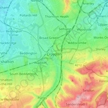
Name: Croydon topographic map, elevation, terrain.
Location: Croydon, Greater London, England, CR0 1SZ, United Kingdom (51.33130 -0.14196 51.41130 -0.06196)
Average elevation: 230 ft
Minimum elevation: 66 ft
Maximum elevation: 574 ft
Make a donation
Gear up for your next adventure:
As an Amazon Associate, this site earns from qualifying purchases at no extra cost to you.
Other topographic maps
Click on a map to view its topography, its elevation and its terrain.
Bath
United Kingdom > England > Bath and North East Somerset
Bath is in the Avon Valley and is surrounded by limestone hills as it is near the southern edge of the Cotswolds, a designated Area of Outstanding Natural Beauty, and the limestone Mendip Hills rise around 7 miles (11 km) south of the city. The hills that surround and make up the city have a maximum altitude…
Average elevation: 328 ft
Make a donation
Gear up for your next adventure:
As an Amazon Associate, this site earns from qualifying purchases at no extra cost to you.
Sheffield
Sheffield nestles on the eastern foothills of the Pennines and is sculpted by a dramatic hill-and-valley system formed where five rivers — the Don, Sheaf, Rivelin, Loxley and Porter — converge, producing steep-sided valleys and gritstone ridgelines with much of the urban area built directly onto hillsides…
Average elevation: 551 ft
East of England
The East of England region has the lowest elevation range in the UK. Twenty percent of the region is below mean sea level, most of this in North Cambridgeshire, Norfolk and on the Essex Coast. Most of the remaining area is of low elevation, with extensive glacial deposits. The Fens, a large area of reclaimed…
Average elevation: 128 ft
Make a donation
Gear up for your next adventure:
As an Amazon Associate, this site earns from qualifying purchases at no extra cost to you.
Cambridge
United Kingdom > England > Cambridge
The city, like most of the UK, has a maritime climate highly influenced by the Gulf Stream. Located in the driest region of Britain, Cambridge's rainfall averages around 570 mm (22.44 in) per year, around half the national average, with some years occasionally falling into the semi-arid (under 500 mm (19.69…
Average elevation: 59 ft
Make a donation
Gear up for your next adventure:
As an Amazon Associate, this site earns from qualifying purchases at no extra cost to you.
South East England
Near Weybridge are the UK headquarters of Sony with SSP Group (situated in Byfleet) and Procter & Gamble (next door to each other on The Heights Business Park near the former Brooklands racing circuit) with Kia Motors UK and Petroleum Geo-Services UK, and Gallaher Group (cigarettes) is to the north, next to…
Average elevation: 226 ft
Make a donation
Gear up for your next adventure:
As an Amazon Associate, this site earns from qualifying purchases at no extra cost to you.
Surrey
United Kingdom > England > Surrey
The highest elevation in Surrey is Leith Hill near Dorking. It is 295 m (968 ft) above sea level and is the second highest point in southeastern England after Walbury Hill in West Berkshire which is 297 m (974 ft).
Average elevation: 226 ft
Make a donation
Gear up for your next adventure:
As an Amazon Associate, this site earns from qualifying purchases at no extra cost to you.
Kent
Kent was also the location of the largest number of art schools in the country during the nineteenth century, estimated by the art historian David Haste, to approach two hundred. This is believed to be the result of Kent being a front line county during the Napoleonic Wars. At this time, before the invention…
Average elevation: 121 ft
Lake District National Park
The Lake District is a roughly circular upland massif, deeply dissected by a broadly radial pattern of major valleys which are largely the result of repeated glaciations over the last 2 million years. The apparent radial pattern is not from a central dome, but from an axial watershed extending from St Bees…
Average elevation: 676 ft
Suffolk
The west of the county lies on more resistant Cretaceous chalk. This chalk is responsible for a sweeping tract of largely downland landscapes that stretches from Dorset in the south west to Dover in the south east and north through East Anglia to the Yorkshire Wolds. The chalk is less easily eroded so forms…
Average elevation: 115 ft
Make a donation
Gear up for your next adventure:
As an Amazon Associate, this site earns from qualifying purchases at no extra cost to you.
Cornwall
The interior of the county consists of a roughly east–west spine of infertile and exposed upland, with a series of granite intrusions, such as Bodmin Moor, which contains the highest land within Cornwall. From east to west, and with approximately descending altitude, these are Bodmin Moor, Hensbarrow north…
Average elevation: 180 ft
Birmingham
Birmingham is a snowy city relative to other large UK conurbations, due to its inland location and comparatively high elevation. Between 1961 and 1990 Birmingham Airport averaged 13.0 days of snow lying annually, compared to 5.33 at London Heathrow. Snow showers often pass through the city via the Cheshire gap…
Average elevation: 453 ft
Make a donation
Gear up for your next adventure:
As an Amazon Associate, this site earns from qualifying purchases at no extra cost to you.
Make a donation
Gear up for your next adventure:
As an Amazon Associate, this site earns from qualifying purchases at no extra cost to you.
Make a donation
Gear up for your next adventure:
As an Amazon Associate, this site earns from qualifying purchases at no extra cost to you.
Godalming
United Kingdom > England > Surrey > Waverley
Elevations vary between 36 m (118 ft) AOD by the Guildford Road Rugby Union ground and Broadwater lake at the River Wey's exit from Godalming into Peasmarsh, Shalford, and 106 m (347.76 ft) AOD where Quarter Mile meets Hambledon Road (both residential) in the south-east. Hurtmore Road is also residential:…
Average elevation: 233 ft
Make a donation
Gear up for your next adventure:
As an Amazon Associate, this site earns from qualifying purchases at no extra cost to you.
Make a donation
Gear up for your next adventure:
As an Amazon Associate, this site earns from qualifying purchases at no extra cost to you.
Make a donation
Gear up for your next adventure:
As an Amazon Associate, this site earns from qualifying purchases at no extra cost to you.
Yorkshire
In Yorkshire there is a very close relationship between the major topographical areas and the geological period in which they were formed. The Pennine chain of hills in the west is of Carboniferous origin. The central vale is Permo-Triassic. The North York Moors in the north-east of the county are Jurassic in…
Average elevation: 427 ft
Make a donation
Gear up for your next adventure:
As an Amazon Associate, this site earns from qualifying purchases at no extra cost to you.
North East England
North East England has a Marine west coast climate (generally found along the west coast of middle latitude continents) with narrower temperature ranges than the south of England and sufficient precipitation in all months. Summers and winters are mild rather than extremely hot or cold, due to the strong…
Average elevation: 541 ft
Make a donation
Gear up for your next adventure:
As an Amazon Associate, this site earns from qualifying purchases at no extra cost to you.
Make a donation
Gear up for your next adventure:
As an Amazon Associate, this site earns from qualifying purchases at no extra cost to you.
Borough of Luton
The local climate around Luton is differentiated somewhat from much of South East England due to its position in the Chiltern Hills, meaning it tends to be 1–2 degrees Celsius cooler than the surrounding towns – often flights at Luton airport, lying 160 m (525 ft) above sea level, will be suspended when…
Average elevation: 479 ft
Surrey
The highest elevation in Surrey is Leith Hill near Dorking. It is 295 m (968 ft) above sea level and is the second highest point in southeastern England after Walbury Hill in West Berkshire which is 297 m (974 ft).
Average elevation: 226 ft
Make a donation
Gear up for your next adventure:
As an Amazon Associate, this site earns from qualifying purchases at no extra cost to you.
East Midlands
The highest point at 636 m (2,087 ft) is Kinder Scout, in the Peak District of the southern Pennines in northwest Derbyshire near Glossop. Other hilly areas of 95 to 280 m (312 to 919 ft) in altitude, together with lakes and reservoirs, rise in and around the Charnwood Forest north of Peterborough, Leicester,…
Average elevation: 246 ft
Make a donation
Gear up for your next adventure:
As an Amazon Associate, this site earns from qualifying purchases at no extra cost to you.
Daventry
United Kingdom > England > West Northamptonshire
According to local folklore Daventry had Danish (Viking) origins, this was partly due to the old pronunciation of Daventry as Daintry, which was interpreted as "Dane Tree", however in more modern interpretation the town's name is thought likelier to be Anglo-Saxon in origin: "Dafa's tree" (Dafa being a…
Average elevation: 486 ft
Make a donation
Gear up for your next adventure:
As an Amazon Associate, this site earns from qualifying purchases at no extra cost to you.
Yorkshire
In Yorkshire there is a very close relationship between the major topographical areas and the geological period in which they were formed. The Pennine chain of hills in the west is of Carboniferous origin. The central vale is Permo-Triassic. The North York Moors in the north-east of the county are Jurassic in…
Average elevation: 427 ft
Make a donation
Gear up for your next adventure:
As an Amazon Associate, this site earns from qualifying purchases at no extra cost to you.
Hyde Park
United Kingdom > England > London
"It consists of a screen of handsome fluted Ionic columns, with three carriage entrance archways, two-foot entrances, a lodge, etc. The extent of the whole frontage is about 107 ft (33 m). The central entrance has a bold projection: the entablature is supported by four columns; and the volutes of the capitals…
Average elevation: 82 ft
Reading
Jane Austen attended Reading Ladies Boarding School, based in the Abbey Gateway, in 1784–1786. Mary Russell Mitford lived in Reading for a number of years and then spent the rest of her life just outside the town at Three Mile Cross and Swallowfield. The fictional Belford Regis of her eponymous novel, first…
Average elevation: 177 ft
Make a donation
Gear up for your next adventure:
As an Amazon Associate, this site earns from qualifying purchases at no extra cost to you.
River Tees
The source of the river at Teeshead just below Cross Fell is at an elevation of about 2,401 feet (732 m). It flows east-north-east through an area of shake holes through Carboniferous Limestone. Below Viewing Hill, it turns south to the Cow Green Reservoir constructed to store water to be released in dry…
Average elevation: 715 ft
Make a donation
Gear up for your next adventure:
As an Amazon Associate, this site earns from qualifying purchases at no extra cost to you.
Berkshire
United Kingdom > England > Reading
All of the county is drained by the Thames. Berkshire divides into two topological (and associated geological) sections: east and west of Reading. North-east Berkshire has the low calciferous (limestone) m-shaped bends of the Thames south of which is a broader, clayey, gravelly former watery plain or belt from…
Average elevation: 328 ft
Exeter
United Kingdom > England > Devon
The city of Exeter was established on the eastern bank of the River Exe on a ridge of land backed by a steep hill. It is at this point that the Exe, having just been joined by the River Creedy, opens onto a wide flood plain and estuary which results in quite common flooding. Historically this was the lowest…
Average elevation: 184 ft
Make a donation
Gear up for your next adventure:
As an Amazon Associate, this site earns from qualifying purchases at no extra cost to you.
Lincoln
United Kingdom > England > Lincolnshire
Lincoln lies 157 mi (253 km) north of London, at an altitude of 67 ft (20.4 m) by the River Witham up to 246 ft (75.0 m) on Castle Hill. It fills a gap in the Lincoln Cliff escarpment, which runs north and south through central Lincolnshire, with altitudes up to 200 feet (61 metres). The city lies on the River…
Average elevation: 95 ft
Make a donation
Gear up for your next adventure:
As an Amazon Associate, this site earns from qualifying purchases at no extra cost to you.
Make a donation
Gear up for your next adventure:
As an Amazon Associate, this site earns from qualifying purchases at no extra cost to you.
Make a donation
Gear up for your next adventure:
As an Amazon Associate, this site earns from qualifying purchases at no extra cost to you.