Geolocate

Lincoln topographic map

Click on the map to display elevation.

Lincoln

Lincoln lies 157 mi (253 km) north of London, at an altitude of 67 ft (20.4 m) by the River Witham up to 246 ft (75.0 m) on Castle Hill. It fills a gap in the Lincoln Cliff escarpment, which runs north and south through central Lincolnshire, with altitudes up to 200 feet (61 metres). The city lies on the River Witham, which flows through this gap. The city is 55 miles (123 km) southwest of Hull, 32 miles (51 km) north-east of Nottingham, 47 miles (76 km) north of Peterborough, 82 miles (133 km) southeast of Leeds and 40 miles (64 km) east south-east of Sheffield.

Wikipedia (CC-BY-SA 3.0)

About this map

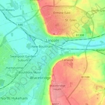
Name: Lincoln topographic map, elevation, terrain.

Location: Lincoln, Lincolnshire, Greater Lincolnshire, England, United Kingdom (53.18630 -0.62262 53.25455 -0.49392)

Average elevation: 95 ft

Minimum elevation: -3 ft

Maximum elevation: 256 ft

Other topographic maps

Click on a map to view its topography, its elevation and its terrain.

Stamford

United Kingdom > England > Lincolnshire > South Kesteven

Average elevation: 171 ft

Ewerby

United Kingdom > England > Lincolnshire > North Kesteven

Average elevation: 36 ft

Branston

United Kingdom > England > Lincolnshire > North Kesteven

Average elevation: 131 ft

Greylees

United Kingdom > England > Lincolnshire > North Kesteven

Average elevation: 95 ft

Sudbrooke

United Kingdom > England > Lincolnshire > West Lindsey

Average elevation: 56 ft

Manthorpe

United Kingdom > England > Lincolnshire > South Kesteven

Average elevation: 105 ft

Steep Hill

United Kingdom > England > Lincolnshire > Lincoln

Average elevation: 105 ft

Frampton

United Kingdom > England > Lincolnshire > Boston

Average elevation: 13 ft

Risegate

United Kingdom > England > Lincolnshire > South Holland

Average elevation: 13 ft

Holland Fen

United Kingdom > England > Lincolnshire > Boston

Average elevation: 10 ft

Lincoln Castle

United Kingdom > England > Lincolnshire > Lincoln

Average elevation: 105 ft

Bourne

United Kingdom > England > Lincolnshire > South Kesteven

Average elevation: 69 ft

Brandon

United Kingdom > England > Lincolnshire > South Kesteven

Average elevation: 82 ft

West Keal

United Kingdom > England > Lincolnshire > East Lindsey

Average elevation: 102 ft

Hagnaby

United Kingdom > England > Lincolnshire > East Lindsey

Average elevation: 13 ft

Fiskerton

United Kingdom > England > Lincolnshire > West Lindsey

Average elevation: 33 ft

Ancaster

United Kingdom > England > Lincolnshire > South Kesteven

Average elevation: 220 ft

Cranwell

United Kingdom > England > Lincolnshire > North Kesteven

Average elevation: 151 ft

Saleby

United Kingdom > England > Lincolnshire > East Lindsey > Alford

Average elevation: 30 ft

Wragholme

United Kingdom > England > Lincolnshire > East Lindsey

Average elevation: 10 ft

Oasby

United Kingdom > England > Lincolnshire > South Kesteven

Average elevation: 269 ft

Creeton

United Kingdom > England > Lincolnshire > South Kesteven

Average elevation: 223 ft

Swayfield

United Kingdom > England > Lincolnshire > South Kesteven

Average elevation: 269 ft

Ingoldsby

United Kingdom > England > Lincolnshire > South Kesteven

Average elevation: 240 ft

Quadring

United Kingdom > England > Lincolnshire > South Holland

Average elevation: 13 ft

Bracebridge

United Kingdom > England > Lincolnshire > Lincoln

Average elevation: 92 ft

Raithby

United Kingdom > England > Lincolnshire > East Lindsey

Average elevation: 177 ft

Benington

United Kingdom > England > Lincolnshire > Boston

Average elevation: 13 ft

Boston

United Kingdom > England > Lincolnshire > Boston > Boston

Average elevation: 13 ft

Goulceby

United Kingdom > England > Lincolnshire > East Lindsey

Average elevation: 272 ft

Grantham

United Kingdom > England > Lincolnshire > South Kesteven

Average elevation: 285 ft

Folkingham

United Kingdom > England > Lincolnshire > South Kesteven

Average elevation: 148 ft

Swineshead

United Kingdom > England > Lincolnshire > Boston

Average elevation: 13 ft

Anwick

United Kingdom > England > Lincolnshire > North Kesteven

Average elevation: 23 ft

Sutterby

United Kingdom > England > Lincolnshire > East Lindsey > Brinkhill

Average elevation: 207 ft

Welton

United Kingdom > England > Lincolnshire > West Lindsey

Average elevation: 72 ft

Aby

United Kingdom > England > Lincolnshire > East Lindsey

Average elevation: 75 ft

Fold Hill

United Kingdom > England > Lincolnshire > East Lindsey

Average elevation: 10 ft

Dunston

United Kingdom > England > Lincolnshire > North Kesteven

Average elevation: 69 ft

Bulby

United Kingdom > England > Lincolnshire > South Kesteven

Average elevation: 203 ft

Knaith Park

United Kingdom > England > Lincolnshire > West Lindsey > Lea

Average elevation: 62 ft

Pickworth

United Kingdom > England > Lincolnshire > South Kesteven

Average elevation: 217 ft

Langtoft

United Kingdom > England > Lincolnshire > South Kesteven

Average elevation: 26 ft

Drayton

United Kingdom > England > Lincolnshire > Boston > Swineshead

Average elevation: 13 ft

Leadenham

United Kingdom > England > Lincolnshire > North Kesteven

Average elevation: 157 ft

Dunholme

United Kingdom > England > Lincolnshire > West Lindsey

Average elevation: 62 ft

Coleby

United Kingdom > England > Lincolnshire > North Kesteven

Average elevation: 164 ft

Spanby

United Kingdom > England > Lincolnshire > North Kesteven

Average elevation: 59 ft

Baston

United Kingdom > England > Lincolnshire > South Kesteven

Average elevation: 33 ft

Pointon

United Kingdom > England > Lincolnshire > South Kesteven

Average elevation: 49 ft

Welbourn

United Kingdom > England > Lincolnshire > North Kesteven

Average elevation: 164 ft

Aswarby

United Kingdom > England > Lincolnshire > North Kesteven

Average elevation: 69 ft

Kirton Holme

United Kingdom > England > Lincolnshire > Boston > Kirton CP

Average elevation: 13 ft

Gear up for your next adventure:

🎒Day Hiking Backpack - Lightweight backpack perfect for day trips and outdoor adventures
🖼️Topo Map Wall Art - Decorative topographic prints of famous peaks and regions
🦟Ultrasonic Repellers - Create a bug-free zone at your camp or rest stop
🛌Ultralight Sleeping Bags - Compact down bags for cold nights in the wilderness
🎒Trail Energy Bars - High‑calorie bars for hiking energy

As an Amazon Associate, this site earns from qualifying purchases at no extra cost to you.