
Budapest topographic map
Click on the map to display elevation.
Budapest
The wide Danube was always fordable at this point because of a small number of islands in the middle of the river. The city has marked topographical contrasts: Buda is built on the higher river terraces and hills of the western side, while the considerably larger Pest spreads out on a flat and featureless sand plain on the river's opposite bank. Pest's terrain rises with a slight eastward gradient, so the easternmost parts of the city lie at the same elevation as Buda's smallest hills, notably Gellért Hill and Castle Hill.
About this map
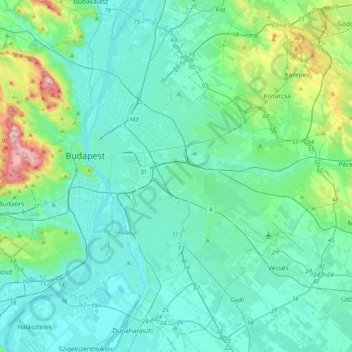
Name: Budapest topographic map, elevation, terrain.
Location: Budapest, Central Hungary, Hungary (47.34969 18.92511 47.61315 19.33493)
Average elevation: 502 ft
Minimum elevation: 292 ft
Maximum elevation: 1,680 ft
Other topographic maps
Click on a map to view its topography, its elevation and its terrain.
Pannonian Basin
Pannonian basin vs Carpathian basin: On the territory of present-day Hungary the ancient Roman Pannonia province was located only on Transdanubian territories, however the Great Hungarian Plain was not part of Pannonia province. This comprises less than 29% of modern Hungary, therefore Hungarian geographers…
Average elevation: 325 ft
Pécs
Pécs is bordered by plains to the south (elevation 120–130 m), while the Mecsek mountains rise up to elevations of 400–600 meters behind the city. Jakab-hill, located in the western Mecsek, is 592 m (1942 ft) tall, Tubes, straight above Pécs, is 612 m (2008 ft) tall, and Misina is 535 m (1755 ft) tall.…
Average elevation: 689 ft
Zemplén Mountains
Zemplén Mountains (Hungarian: [ˈzɛmpleːn]) or Tokaj Mountains (Hungarian: [ˈtokɒj]; Hungarian: Zempléni-hegység or Tokaji-hegység) is a mountain range in Hungary. The Zemplén Mountains form part of the Tokaj-Eperjes mountain chain in Hungary, known for their ecological richness and historical…
Average elevation: 676 ft
Vértes
The area of the Vértes occupies 314 km2 (121 sq mi). It is about 30 km long and 10–15 km wide. The average altitude is above sea level is 350 meters; its highest points are 487 m (Nagy-Csákány), 480 m (Körtvélyes) and 479 m (Csóka-hegy). Geologically the Vértes constitute a fairly uniform structure.…
Average elevation: 804 ft