
Chaclacayo topographic map
Click on the map to display elevation.
Chaclacayo
El distrito de Chaclacayo se localiza a 11º 58' Latitud Sur, 76º 46' Longitud Oeste a una altitud de 647 msnm, ubicado a 27 km del centro de Lima por la Carretera Central. Limita separándose por el río Rímac al norte y al este con el distrito de Lurigancho-Chosica, al sur con el distrito de Cieneguilla y al oeste con el distrito de Huaycán.
About this map
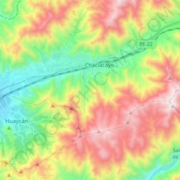
Name: Chaclacayo topographic map, elevation, terrain.
Location: Chaclacayo, Lima, Lima Metropolitana, Lima, Perú (-12.02325 -76.83720 -11.96155 -76.71479)
Average elevation: 3,438 ft
Minimum elevation: 1,657 ft
Maximum elevation: 5,778 ft
Other topographic maps
Click on a map to view its topography, its elevation and its terrain.
San Vicente de Cañete
Perú > Lima > San Vicente de Cañete
La ciudad de San Vicente de Cañete se encuentra a 144 km de la ciudad de Lima, a orillas del río Cañete, a una altitud de 40 msnm.
Average elevation: 577 ft
San Mateo de Huanchor
San Mateo de Huánchor es una localidad peruana, capital del distrito homónimo ubicado en la provincia de Huarochirí en el departamento de Lima. Administrativamente se halla en la circunscripción del Gobierno Regional de Lima. Se encuentra a una altitud de 3149 m s. n. m. Tiene una población de 3347…
Average elevation: 12,208 ft
Lima
Solo muy pocas veces ha llovido intensamente en la ciudad. El fenómeno de la lluvia se da especialmente en los distritos con mayor altitud como en Lurigancho-Chosica. Durante este siglo XXI, una de las lluvias más fuertes que hubo en la ciudad fue soportada por los distritos de Cieneguilla, Pachacámac,…
Average elevation: 774 ft
San Agustín de Huayopampa
Perú > Lima > Atavillos Bajo > San Agustín de Huayopampa
Average elevation: 7,041 ft