
Make a donation
Gear up for your next adventure:
As an Amazon Associate, this site earns from qualifying purchases at no extra cost to you.
Stuttgart topographic map
Click on the map to display elevation.
Make a donation
Gear up for your next adventure:
As an Amazon Associate, this site earns from qualifying purchases at no extra cost to you.
Stuttgart
Stuttgart covers an area of 207.35 km2 (80 sq mi) and sits at elevation ranging from 207 m (679 ft) above sea level by the Neckar river to 549 m (1,801 ft) on Bernhartshöhe hill – something rather unique in large German cities. The most prominent elevated locales in Stuttgart are the Birkenkopf (511 m (1,677 ft)) on the edge of the Stuttgart basin, the Württemberg (411 m (1,348 ft)) rising above the Neckar valley, and the Grüner Heiner (395 m (1,296 ft)) at the northeast end of the city.
Make a donation
Gear up for your next adventure:
As an Amazon Associate, this site earns from qualifying purchases at no extra cost to you.
About this map
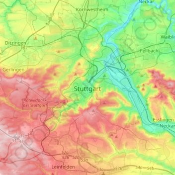
Name: Stuttgart topographic map, elevation, terrain.
Location: Stuttgart, Baden-Württemberg, Germany (48.69202 9.03860 48.86640 9.31602)
Average elevation: 1,152 ft
Minimum elevation: 676 ft
Maximum elevation: 1,752 ft
Make a donation
Gear up for your next adventure:
As an Amazon Associate, this site earns from qualifying purchases at no extra cost to you.
Other topographic maps
Click on a map to view its topography, its elevation and its terrain.
Stuttgart
Germany > Baden-Württemberg > Stuttgart
Stuttgart covers an area of 207.35 km2 (80 sq mi) and sits at elevation ranging from 207 m (679 ft) above sea level by the Neckar river to 549 m (1,801 ft) on Bernhartshöhe hill – something rather unique in large German cities. The most prominent elevated locales in Stuttgart are the Birkenkopf (511 m…
Average elevation: 1,158 ft
Make a donation
Gear up for your next adventure:
As an Amazon Associate, this site earns from qualifying purchases at no extra cost to you.
Wilflingen
Germany > Baden-Württemberg > Ostalbkreis > Abtsgmünd
The main town of Abtsgmünd lies at the confluence of the Lein river into the Kocher (confluence elevation 367.4 m above sea level), predominantly on the left bank of the Kocher and left bank of the Lein. The furthest district of Untergröningen lies over 8 km west-northwest as the crow flies along two river…
Average elevation: 1,417 ft
Escheck
Germany > Baden-Württemberg > Schwarzwald-Baar-Kreis > Furtwangen im Schwarzwald
Average elevation: 3,317 ft
Make a donation
Gear up for your next adventure:
As an Amazon Associate, this site earns from qualifying purchases at no extra cost to you.
Rielingshausen
Germany > Baden-Württemberg > Landkreis Ludwigsburg > Marbach am Neckar
Average elevation: 955 ft
Make a donation
Gear up for your next adventure:
As an Amazon Associate, this site earns from qualifying purchases at no extra cost to you.
Obertüllingen
Germany > Baden-Württemberg > Landkreis Lörrach > Lörrach > Untertüllingen
Average elevation: 1,007 ft
Nussdorf
Germany > Baden-Württemberg > Landkreis Ludwigsburg
The municipality (Gemeinde) of Eberdingen is located at the western extremity of the district of Ludwigsburg, in the German state of Baden-Württemberg, along its border with the districts of Böblingen and the Enz. Eberdingen is physically located in the basin of [de] the Neckar. Elevation above sea level in…
Average elevation: 1,053 ft
Make a donation
Gear up for your next adventure:
As an Amazon Associate, this site earns from qualifying purchases at no extra cost to you.
Großherrischwand
Germany > Baden-Württemberg > Landkreis Waldshut > Herrischried
Average elevation: 3,018 ft
Inneringen
Germany > Baden-Württemberg > Landkreis Sigmaringen > Hettingen
Average elevation: 2,579 ft
Kleinallmerspann
Germany > Baden-Württemberg > Landkreis Schwäbisch Hall > Kirchberg an der Jagst
Average elevation: 1,411 ft
Make a donation
Gear up for your next adventure:
As an Amazon Associate, this site earns from qualifying purchases at no extra cost to you.
Mattenhof
Germany > Baden-Württemberg > Ortenaukreis > Gutach (Schwarzwaldbahn)
Average elevation: 1,319 ft
Make a donation
Gear up for your next adventure:
As an Amazon Associate, this site earns from qualifying purchases at no extra cost to you.
Hauenstein
Germany > Baden-Württemberg > Landkreis Waldshut > Laufenburg (Baden) > Luttingen
Average elevation: 1,257 ft
Kapfenburg
Germany > Baden-Württemberg > Ostalbkreis > Lauchheim > Domäne Kapfenburg
Average elevation: 1,834 ft
Make a donation
Gear up for your next adventure:
As an Amazon Associate, this site earns from qualifying purchases at no extra cost to you.
Riet
Germany > Baden-Württemberg > Landkreis Ludwigsburg > Vaihingen an der Enz
Average elevation: 1,020 ft
Make a donation
Gear up for your next adventure:
As an Amazon Associate, this site earns from qualifying purchases at no extra cost to you.
Steinbronnen
Germany > Baden-Württemberg > Landkreis Sigmaringen > Bad Saulgau > Bierstetten
Average elevation: 2,093 ft
Ableitung Erms
Germany > Baden-Württemberg > Landkreis Reutlingen > Dettingen an der Erms
Average elevation: 1,581 ft
Broggingen
Germany > Baden-Württemberg > Landkreis Emmendingen > Herbolzheim
Average elevation: 820 ft
Make a donation
Gear up for your next adventure:
As an Amazon Associate, this site earns from qualifying purchases at no extra cost to you.
Dietenbach
Germany > Baden-Württemberg > Landkreis Breisgau-Hochschwarzwald > Kirchzarten (Kernort) > Kirchzarten
Average elevation: 1,581 ft
Sinsheim-Steinsfurt / Insenbach
Germany > Baden-Württemberg > Rhein-Neckar-Kreis > Sinsheim
Average elevation: 669 ft
Make a donation
Gear up for your next adventure:
As an Amazon Associate, this site earns from qualifying purchases at no extra cost to you.
Rickelshausen
Germany > Baden-Württemberg > Landkreis Konstanz > Radolfzell am Bodensee > Böhringen
Average elevation: 1,332 ft
Ground Zero
Germany > Baden-Württemberg > Landkreis Ludwigsburg > Ludwigsburg
Average elevation: 997 ft
Dörnich
Germany > Baden-Württemberg > Rems-Murr-Kreis > Sulzbach an der Murr
Average elevation: 1,342 ft
Friedrichsturm
Germany > Baden-Württemberg > Landkreis Freudenstadt > Freudenstadt
Average elevation: 2,470 ft
Make a donation
Gear up for your next adventure:
As an Amazon Associate, this site earns from qualifying purchases at no extra cost to you.
Bad Teinach
Germany > Baden-Württemberg > Landkreis Calw
The township (Stadt) of Bad Teinach-Zavelstein is located at the center of the district of Calw, in Baden-Württemberg, one of the 16 States of the Federal Republic of Germany. Bad Teinach-Zavelstein's municipal area rests upon the plateau of the Enz and Nagold rivers, a landscape defined by severe river…
Average elevation: 1,827 ft
Make a donation
Gear up for your next adventure:
As an Amazon Associate, this site earns from qualifying purchases at no extra cost to you.
Tonbach
Germany > Baden-Württemberg > Landkreis Freudenstadt > Baiersbronn
Average elevation: 2,215 ft
Make a donation
Gear up for your next adventure:
As an Amazon Associate, this site earns from qualifying purchases at no extra cost to you.
Obergieß
Germany > Baden-Württemberg > Ortenaukreis > Hornberg > Niederwasser
Average elevation: 2,352 ft
Nördlinger Stein
Germany > Baden-Württemberg > Landkreis Heidenheim > Königsbronn > Zahnberg
Average elevation: 1,923 ft
Make a donation
Gear up for your next adventure:
As an Amazon Associate, this site earns from qualifying purchases at no extra cost to you.
Hohenhaslach
Germany > Baden-Württemberg > Landkreis Ludwigsburg > Sachsenheim
Average elevation: 922 ft
Make a donation
Gear up for your next adventure:
As an Amazon Associate, this site earns from qualifying purchases at no extra cost to you.
Hinterdenkental
Germany > Baden-Württemberg > Alb-Donau-Kreis > Westerstetten
Average elevation: 1,978 ft
Nordschwaben
Germany > Baden-Württemberg > Landkreis Lörrach > Rheinfelden (Baden)
Average elevation: 1,463 ft
Schnaitheim
Germany > Baden-Württemberg > Landkreis Heidenheim > Heidenheim an der Brenz
Average elevation: 1,808 ft
Make a donation
Gear up for your next adventure:
As an Amazon Associate, this site earns from qualifying purchases at no extra cost to you.
Heidelberg Castle
Germany > Baden-Württemberg > Heidelberg > Königstuhl
All of these works are for the most part superficial and do not contain much information. In 1615, Merian's Topographia Palatinatus Rheni described Prince Elector Ludwig V as he "started building a new castle one hundred and more years ago". Most of the descriptions of the castle up until the 18th century are…
Average elevation: 919 ft
Make a donation
Gear up for your next adventure:
As an Amazon Associate, this site earns from qualifying purchases at no extra cost to you.
Schnepfenstand
Germany > Baden-Württemberg > Landkreis Heidenheim > Herbrechtingen
Average elevation: 1,883 ft
Kleinhegnach
Germany > Baden-Württemberg > Rems-Murr-Kreis > Waiblingen > Neustadt
Average elevation: 909 ft
Make a donation
Gear up for your next adventure:
As an Amazon Associate, this site earns from qualifying purchases at no extra cost to you.
Hohenzollern Castle
Germany > Baden-Württemberg > Zollernalbkreis > Bisingen
Average elevation: 2,073 ft
Lippisbacher Hof
Germany > Baden-Württemberg > Landkreis Lörrach > Obereggenen
Average elevation: 2,116 ft
Im Stock
Germany > Baden-Württemberg > Lake Constance district > Bermatingen
Average elevation: 1,555 ft
Make a donation
Gear up for your next adventure:
As an Amazon Associate, this site earns from qualifying purchases at no extra cost to you.
Hopfenweiler
Germany > Baden-Württemberg > Landkreis Ravensburg > Bad Waldsee
Average elevation: 2,028 ft
Rheintal
Germany > Baden-Württemberg > Landkreis Breisgau-Hochschwarzwald > Müllheim im Markgräflerland
Average elevation: 1,391 ft
Make a donation
Gear up for your next adventure:
As an Amazon Associate, this site earns from qualifying purchases at no extra cost to you.
Apfelstetten
Germany > Baden-Württemberg > Landkreis Reutlingen > Münsingen
Average elevation: 2,477 ft
Make a donation
Gear up for your next adventure:
As an Amazon Associate, this site earns from qualifying purchases at no extra cost to you.
Bleiche
Germany > Baden-Württemberg > Landkreis Konstanz > Stockach > Hindelwangen
Average elevation: 1,860 ft
Make a donation
Gear up for your next adventure:
As an Amazon Associate, this site earns from qualifying purchases at no extra cost to you.
Make a donation
Gear up for your next adventure:
As an Amazon Associate, this site earns from qualifying purchases at no extra cost to you.
Bad Rippoldsau
Germany > Baden-Württemberg > Landkreis Freudenstadt > Bad Rippoldsau-Schapbach
Average elevation: 2,349 ft
Make a donation
Gear up for your next adventure:
As an Amazon Associate, this site earns from qualifying purchases at no extra cost to you.
Torfwerk
Germany > Baden-Württemberg > Landkreis Biberach > Bad Schussenried
Average elevation: 1,932 ft
Galgenbühl
Germany > Baden-Württemberg > Landkreis Ravensburg > Zaisenhofen
Average elevation: 2,162 ft
Untergreifenstein
Germany > Baden-Württemberg > Landkreis Reutlingen > Lichtenstein
Average elevation: 2,169 ft
Make a donation
Gear up for your next adventure:
As an Amazon Associate, this site earns from qualifying purchases at no extra cost to you.