Geolocate

蒲缥镇 topographic map

Interactive map

Click on the map to display elevation.

About this map

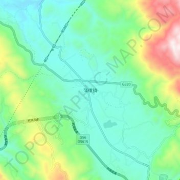
Name: 蒲缥镇 topographic map, elevation, terrain.

Location: 蒲缥镇, 保山市, 云南省, 中国 (24.96980 98.97940 25.04980 99.05940)

Average elevation: 5,141 ft

Minimum elevation: 4,193 ft

Maximum elevation: 7,726 ft

Other topographic maps

Click on a map to view its topography, its elevation and its terrain.

滇滩镇

中国 > 云南省 > 保山市

滇滩镇, 保山市, 云南省, 中国

Average elevation: 6,663 ft

芒宽乡

中国 > 云南省 > 保山市

芒宽乡, 保山市, 云南省, 中国

Average elevation: 3,632 ft

旧城乡

中国 > 云南省 > 保山市

旧城乡, 保山市, 云南省, 中国

Average elevation: 3,517 ft

固东镇

中国 > 云南省 > 保山市

固东镇, 保山市, 云南省, 中国

Average elevation: 6,099 ft

猴桥镇

中国 > 云南省 > 保山市

猴桥镇, 保山市, 云南省, 中国

Average elevation: 6,184 ft

腾冲市

中国 > 云南省 > 保山市

腾冲市, 保山市, 云南省, 679100, 中国

Average elevation: 6,004 ft

瓦房乡

中国 > 云南省 > 保山市

瓦房乡, 保山市, 云南省, 中国

Average elevation: 6,473 ft

界头镇

中国 > 云南省 > 保山市

界头镇, 保山市, 云南省, 中国

Average elevation: 5,440 ft

潞江镇

中国 > 云南省 > 保山市

潞江镇, 保山市, 云南省, 中国

Average elevation: 2,946 ft

龙陵县

中国 > 云南省 > 保山市

龙陵县, 保山市, 云南省, 中国

Average elevation: 5,256 ft

腊勐镇

中国 > 云南省 > 保山市

腊勐镇, 保山市, 云南省, 中国

Average elevation: 4,934 ft