
Plužine Municipality topographic map
Interactive map
Click on the map to display elevation.
About this map
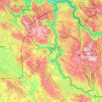
Name: Plužine Municipality topographic map, elevation, terrain.
Location: Plužine Municipality, 81435, Montenegro (42.93345 18.64840 43.36067 19.02345)
Average elevation: 4,390 ft
Minimum elevation: 1,470 ft
Maximum elevation: 8,071 ft
Other topographic maps
Click on a map to view its topography, its elevation and its terrain.
Kolašin
Montenegro > Kolašin Municipality
Kolašin is located on the foot of Bjelasica and Sinjajevina mountains, which offer great conditions for skiing. Because of Kolašin's altitude (954 m), the town is considered an air spa.
Average elevation: 3,717 ft
Žabljak
Montenegro > Žabljak Municipality
Žabljak is the seat of Žabljak Municipality (2011 population: 3,569). The town is in the centre of the Durmitor mountain region and with an altitude of 1,456 metres, it is the highest situated Balkan town.
Average elevation: 4,793 ft