Geolocate

Screven County topographic map

Interactive map

Click on the map to display elevation.

About this map

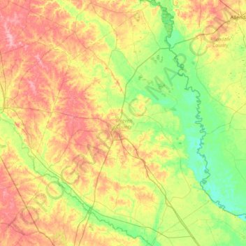
Name: Screven County topographic map, elevation, terrain.

Location: Screven County, Georgia, United States (32.48928 -81.86891 33.04558 -81.38921)

Average elevation: 164 ft

Minimum elevation: 13 ft

Maximum elevation: 384 ft

According to the U.S. Census Bureau, the county has a total area of 656 square miles (1,700 km2), of which 645 square miles (1,670 km2) is land and 11 square miles (28 km2) (1.6%) is water. The Savannah River borders the eastern side of the county, and the Ogeechee River borders the southwest portion. Elevation varies to around 40 feet on the Savannah river to 320 feet at the Bay Branch community, located a few miles west of Sylvania. Pine, oak, dogwood, and other trees prevalent to the South can be found in Screven County.

Wikipedia (CC-BY-SA 3.0)

Other topographic maps

Click on a map to view its topography, its elevation and its terrain.

Atlanta

United States > Georgia > Fulton County

Atlanta, Fulton County, Georgia, United States

Average elevation: 932 ft

Savannah

United States > Georgia > Chatham County

Savannah, Chatham County, Georgia, United States

Average elevation: 13 ft

Helen

United States > Georgia > White County

Helen, White County, Georgia, 30545, United States

Average elevation: 1,601 ft

Cobb County

United States > Georgia

Cobb County, Georgia, United States

Average elevation: 988 ft

Atlanta

United States > Georgia > Fulton County

Atlanta, Fulton County, Georgia, 30303, United States

Average elevation: 935 ft

Columbus

United States > Georgia > Muscogee County

Columbus, Muscogee County, Georgia, United States

Average elevation: 427 ft

DeKalb County

United States > Georgia

DeKalb County, Georgia, United States

Average elevation: 932 ft

Blue Ridge

United States > Georgia > Fannin County

Blue Ridge, Fannin County, Georgia, United States

Average elevation: 1,755 ft

Floyd County

United States > Georgia

Floyd County, Georgia, United States

Average elevation: 781 ft

Blairsville

United States > Georgia > Union County

Blairsville, Union County, Georgia, United States

Average elevation: 1,926 ft

Lumpkin

United States > Georgia > Stewart County

Lumpkin, Stewart County, Georgia, United States

Average elevation: 482 ft

Alapaha River

United States > Georgia

Alapaha River, Georgia, United States

Average elevation: 213 ft

Fannin County

United States > Georgia

Fannin County, Georgia, United States

Average elevation: 2,060 ft

Athens

United States > Georgia > Athens

Athens, Athens-Clarke County, Georgia, 303341458, United States

Average elevation: 725 ft

Dahlonega

United States > Georgia > Lumpkin County

Dahlonega, Lumpkin County, Georgia, United States

Average elevation: 1,348 ft

Saint Simons Island

United States > Georgia > Glynn County

Saint Simons Island, Glynn County, Georgia, 31561, United States

Average elevation: 7 ft

Augusta

United States > Georgia > Augusta

Augusta, Richmond County, Georgia, 30901, United States

Average elevation: 295 ft

Carroll County

United States > Georgia

Carroll County, Georgia, United States

Average elevation: 1,066 ft

Vinings

United States > Georgia > Cobb County

Vinings, Cobb County, Georgia, 30339, United States

Average elevation: 922 ft

Ellijay

United States > Georgia > Gilmer County

Ellijay, Gilmer County, Georgia, 30540, United States

Average elevation: 1,391 ft

Tybee Island

United States > Georgia > Chatham County

Tybee Island, Chatham County, Georgia, 31328, United States

Average elevation: 3 ft

Jointer Island

United States > Georgia > Glynn County > Brunswick

Jointer Island, Brunswick, Glynn County, Georgia, United States

Average elevation: 0 ft

Brunswick

United States > Georgia > Glynn County

Brunswick, Glynn County, Georgia, United States

Average elevation: 7 ft

Macon

United States > Georgia > Bibb County

Macon, Bibb County, Georgia, United States

Average elevation: 417 ft

Heritage Acres

United States > Georgia > Bibb County > Macon

Heritage Acres, Macon, Bibb County, Georgia, 31211, United States

Average elevation: 390 ft

Robins Air Force Base

United States > Georgia > Houston County

Robins Air Force Base, Houston County, Georgia, 31098, United States

Average elevation: 302 ft

Camden County

United States > Georgia

Camden County, Georgia, United States

Average elevation: 13 ft

Union County

United States > Georgia

Union County, Georgia, United States

Average elevation: 2,349 ft

Hiawassee

United States > Georgia > Towns County

Hiawassee, Towns County, Georgia, United States

Average elevation: 2,034 ft

Stone Mountain

United States > Georgia > DeKalb County

Stone Mountain, DeKalb County, Georgia, 30087, United States

Average elevation: 981 ft

Skidaway Island

United States > Georgia > Chatham County

Skidaway Island, Chatham County, Georgia, 31411, United States

Average elevation: 10 ft

Rabun County

United States > Georgia

Rabun County, Georgia, United States

Average elevation: 2,254 ft

Gwinnett County

United States > Georgia

Gwinnett County, Georgia, United States

Average elevation: 991 ft

Mountain City

United States > Georgia > Rabun County

Mountain City, Rabun County, Georgia, 30562, United States

Average elevation: 2,451 ft

Alpharetta

United States > Georgia > Fulton County

Alpharetta, Fulton County, Georgia, United States

Average elevation: 1,063 ft

Lake Oconee

United States > Georgia > Greene County > Lake Oconee

Lake Oconee, Greene County, Georgia, United States

Average elevation: 541 ft

Canton

United States > Georgia > Cherokee County

Canton, Cherokee County, Georgia, United States

Average elevation: 1,050 ft

Woodstock

United States > Georgia > Cherokee County

Woodstock, Cherokee County, Georgia, United States

Average elevation: 971 ft

Iron Mountain

United States > Georgia > Murray County

Iron Mountain, Murray County, Georgia, United States

Average elevation: 1,188 ft

Kennesaw

United States > Georgia > Cobb County

Kennesaw, Cobb County, Georgia, 30144, United States

Average elevation: 1,040 ft

Forsyth County

United States > Georgia

Forsyth County, Georgia, United States

Average elevation: 1,129 ft

Fort Pulaski

United States > Georgia > Chatham County

Fort Pulaski, Fort Perimeter Trail, Chatham County, Georgia, 31328, United States

Average elevation: 3 ft

Tugaloo

United States > Georgia > Habersham County > Tallulah Falls

Tugaloo, Tallulah Falls, Habersham County, Georgia, United States

Average elevation: 1,286 ft

Elmodel

United States > Georgia > Baker County

Elmodel, Baker County, Georgia, United States

Average elevation: 167 ft

Leary

United States > Georgia > Calhoun County

Leary, Calhoun County, Georgia, 39862, United States

Average elevation: 200 ft

Fargo

United States > Georgia > Clinch County

Fargo, Clinch County, Georgia, United States

Average elevation: 112 ft

Gainesville

United States > Georgia > Hall County

Gainesville, Hall County, Georgia, 30501, United States

Average elevation: 1,135 ft

Worley Crossroads

United States > Georgia > Cherokee County

Worley Crossroads, Cherokee County, Georgia, United States

Average elevation: 1,240 ft

Fernwood

United States > Georgia > Fayette County > Peachtree City

Fernwood, Peachtree City, Fayette County, Georgia, 30269, United States

Average elevation: 856 ft

Paulding County

United States > Georgia

Paulding County, Georgia, United States

Average elevation: 1,020 ft