
Hudson River topographic map
Click on the map to display elevation.
Hudson River
The source of the Hudson River is Lake Tear of the Clouds in the Adirondack Park at an elevation of 4,322 feet (1,317 m). However, the river is not cartographically called the Hudson River until miles downstream. The river is named Feldspar Brook until its confluence with the Opalescent River, and then is named the Opalescent River until the river reaches Calamity Brook, flowing south from the outlet of Henderson Lake. From that point on, the stream is cartographically known as the Hudson River. The U.S. Geological Survey (USGS) uses this cartographical definition.
About this map
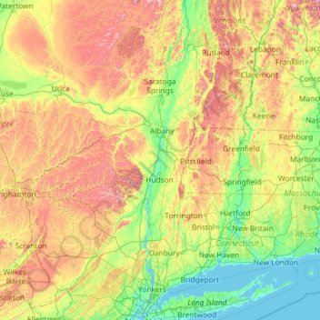
Name: Hudson River topographic map, elevation, terrain.
Location: Hudson River, New York, United States (40.69994 -74.19885 44.09098 -73.57319)
Average elevation: 988 ft
Minimum elevation: -7 ft
Maximum elevation: 4,541 ft
New York trails, hiking, mountain biking, running and outdoor activities
Other topographic maps
Click on a map to view its topography, its elevation and its terrain.
Lake Vanare
United States > New York > Warren County > Town of Lake Luzerne
Average elevation: 1,014 ft
Ontario Pond
United States > New York > Niagara County > City of North Tonawanda
Average elevation: 581 ft
Central Park
United States > New York > New York County > New York
In June 1856, Fernando Wood appointed a "consulting board" of seven people, headed by author Washington Irving, to inspire public confidence in the proposed development. Wood hired military engineer Egbert Ludovicus Viele as the park's chief engineer, tasking him with a topographical survey of the site. The…
Average elevation: 85 ft
Hartmans Corners
United States > New York > Albany County > Town of Guilderland
Average elevation: 266 ft
Brooklyn Bridge Park
United States > New York > Kings County > New York
Brooklyn Bridge Park spans 85 acres (34 ha) of the East River waterfront in the Brooklyn Heights and Dumbo neighborhoods of Brooklyn. The park is divided into eleven sections: Piers 1 through 6; Fulton Ferry Landing; Brooklyn Bridge Plaza; Empire Fulton Ferry; Main Street; and John Street. Each of these…
Average elevation: 30 ft
Potter Hollow
United States > New York > Albany County > Town of Rensselaerville
Average elevation: 1,135 ft
West Coxsackie
United States > New York > Greene County > Village of Coxsackie
Average elevation: 108 ft
Balsam Mountain
United States > New York > Ulster County > Town of Shandaken
Average elevation: 2,746 ft
Oscawana Corners
United States > New York > Putnam County > Town of Putnam Valley
Average elevation: 518 ft
Sunset Ridge
United States > New York > Westchester County > Town/Village of Harrison
Average elevation: 89 ft
Catskills Visitor Center
United States > New York > Ulster County > Town of Shandaken > Beechford
Average elevation: 988 ft
Highland Mills
United States > New York > Orange County > Village of Woodbury
Average elevation: 682 ft
Black Mountain
United States > New York > Washington County
Black Mountain is a mountain located in Washington County, New York, of which its peak is the highest point. Isolated from the rest of the Adirondack Mountains by Lake George, Black Mtn. has the seventh highest topographic prominence of all the mountains in New York. Black Mountain also has the highest…
Average elevation: 1,598 ft
Mount Hope
United States > New York > Westchester County > Village of Hastings-on-Hudson
Average elevation: 197 ft
South Salem
United States > New York > Westchester County > Town of Lewisboro
Average elevation: 571 ft
Speigletown
United States > New York > Rensselaer County > Town of Schaghticoke
Average elevation: 446 ft
Garnerville
United States > New York > Rockland County > Village of West Haverstraw
Average elevation: 262 ft
Barberville
United States > New York > Rensselaer County > Town of Poestenkill
Average elevation: 883 ft
Mount Marcy
United States > New York > Essex County > Town of Keene
Mount Marcy is the highest point in the Adirondack Mountains and the U.S. state of New York, with an elevation of 5,343.1 feet (1,628.6 m). It is located in the town of Keene in Essex County. The mountain is in the heart of the High Peaks Wilderness Area in Adirondack Park. Like the surrounding Adirondack…
Average elevation: 4,229 ft
West Harrison
United States > New York > Westchester County > Town/Village of Harrison
Average elevation: 266 ft
Rosedale
United States > New York > Westchester County > City of White Plains
Average elevation: 187 ft
Smithtown Pines
United States > New York > Suffolk County > Town of Smithtown
Average elevation: 95 ft
Whitesville
United States > New York > Allegany County > Town of Independence
Average elevation: 2,005 ft
Pleasantside
United States > New York > Westchester County > Town of Cortlandt
Average elevation: 354 ft
Brick House Corners
United States > New York > Genesee County > Town of Pembroke
Average elevation: 860 ft