
Nassau County topographic map
Click on the map to display elevation.
Nassau County
There are 12 distinct topographical zones in Nassau County. Most of these zones run in narrow bands stretching from north to south, although this is less true as one approaches the Atlantic coast.
About this map
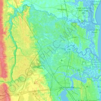
Name: Nassau County topographic map, elevation, terrain.
Location: Nassau County, Florida, United States (30.27334 -82.05043 30.83018 -81.34636)
Average elevation: 43 ft
Minimum elevation: -13 ft
Maximum elevation: 194 ft
Florida trails, hiking, mountain biking, running and outdoor activities
Other topographic maps
Click on a map to view its topography, its elevation and its terrain.
Palm Harbor
United States > Florida > Pinellas County
Palm Harbor is characterized by its unique topography, which features a relatively rare hilly landscape for the region. Unlike much of the surrounding areas in Pinellas County, which are predominantly flat, Palm Harbor includes elevations that can reach up to about 75 feet above sea level. This elevation gives…
Average elevation: 30 ft
Navarre
United States > Florida > Santa Rosa County
Navarre is located at 30°24′04″N 86°51′47″W / 30.401°N 86.863°W / 30.401; -86.863Coordinates: 30°24′04″N 86°51′47″W / 30.401°N 86.863°W / 30.401; -86.863. It is located within a portion of the Florida Panhandle observing the Central Time Zone. Elevation is at an average of 10 feet (3.0 m).
Average elevation: 13 ft
Florida Keys
United States > Florida > Monroe County
Tropical cyclones present special dangers and challenges to the entire Keys. Because no area of the islands is more than 20 feet (6.1 m) above sea level (and many are only a few feet elevation), and water surrounds the islands, nearly every neighborhood is subject to flooding as well as hurricane winds. In…
Average elevation: 0 ft
Parrish
United States > Florida > Manatee County
Parrish features a predominantly flat terrain with an average elevation of approximately 36 feet above sea level. The area's landscape is characterized by gently rolling hills and low-lying regions, making it typical of the Central Florida topography. Surrounding Parrish are numerous wetlands and drainage…
Average elevation: 39 ft
Port Charlotte
United States > Florida > Charlotte County
Port Charlotte is characterized by a predominantly flat and low-lying terrain, typical of Florida’s coastal landscape. The area features a network of waterways, including the Peace River and Charlotte Harbor, which provide ample opportunities for recreational activities like boating and fishing. Elevations…
Average elevation: 13 ft
Lutz
United States > Florida > Hillsborough County > Tampa
Lutz is characterized by a gently rolling topography that showcases the distinctive features of the central Florida landscape. The area has an average elevation of about 70 feet (21 meters) above sea level, contributing to its mild undulations rather than dramatic elevation changes. The terrain is marked by a…
Average elevation: 66 ft
Englewood
United States > Florida > Sarasota County > Englewood
Englewood features predominantly flat and low-lying terrain typical of the region's coastal landscape. The average elevation here is approximately 15 feet above sea level, which makes the area particularly susceptible to tidal influences and storm surges. The terrain is interspersed with wetlands and…
Average elevation: 10 ft
Anna Maria island
United States > Florida > Manatee County
Anna Maria Island features a flat, sandy topography typical of a barrier island on the Gulf Coast. With an average elevation of around 15 feet above sea level, the terrain includes broad beaches, low dunes, and narrow stretches of sandy soil, making it highly vulnerable to storm surges and tidal flooding. The…
Average elevation: 7 ft
Ponte Vedra Beach
United States > Florida > Saint Johns County > Ponte Vedra Beach
Ponte Vedra Beach is characterized by its gently rolling terrain that is primarily flat and lies only about 15 feet above sea level. The landscape is predominantly shaped by coastal dunes and the proximity to the Atlantic Ocean, resulting in sandy beaches interspersed with vegetation typical of barrier island…
Average elevation: 10 ft
Wesley Chapel
United States > Florida > Pasco County
According to the United States Census Bureau, the CDP has a total area of 6.1 square miles (16 km2), of which 6.1 square miles (16 km2) is land and 0.04 square miles (0.10 km2) (0.49%) is water. The elevation is about 100 feet (30 m), combined with an inland location, creates more temperature variation in the…
Average elevation: 62 ft
South Gulf Cove Park
United States > Florida > Charlotte County > Port Charlotte
Average elevation: 10 ft
Whispering Hills Golf Estates
United States > Florida > Brevard County > Titusville
Average elevation: 20 ft
Nokomis
United States > Florida > Sarasota County
Nokomis features a predominantly flat and low-lying terrain characteristic of the coastal region. The elevation in Nokomis rarely exceeds 15 feet above sea level, contributing to its vulnerability to tidal influences and storm surges. The area is interspersed with wetlands and mangroves, particularly near the…
Average elevation: 16 ft
Miccosukee
United States > Florida > Leon County
By 1858, perhaps 200 ancestors of the modern Miccosukee and Seminole Tribes remained in Florida. They survived by moving into central and southern Florida to take advantage of the topography of Big Cypress and the Everglades, which was largely unknown to the remainder of the U.S. The American Civil War during…
Average elevation: 194 ft
Lauderdale Harbors
United States > Florida > Broward County > Fort Lauderdale
Average elevation: 20 ft
Saint Nicholas
United States > Florida > Duval County > Jacksonville > South Jacksonville
Average elevation: 20 ft
Arbors at Freedom Plaza
United States > Florida > Hillsborough County > Sun City Center
Average elevation: 49 ft
Virginia Key Beach North Point Park
United States > Florida > Miami-Dade County > Miami
Average elevation: 10 ft
Georgetown
United States > Florida > Putnam County
Georgetown is located at 29°23′29″N 81°38′19″W / 29.391362°N 81.638689°W / 29.391362; -81.638689 (29.391362, -81.638689). Its elevation in 23 feet (7 m).
Average elevation: 20 ft
Fort De Soto County Park
United States > Florida > Pinellas County > Saint Petersburg
Average elevation: 0 ft
Hibiscus Point Mobile Home Park
United States > Florida > Miami-Dade County > Hialeah
Average elevation: 26 ft
Lake Jackson
United States > Florida > Leon County
The lake is located in the Red Hills Region, and has fluctuated from periods of being dry to a maximum elevation of 96 feet (29 m) above sea level. The lake is approximately 7.5 miles (12 km) long and its area is 6.2 square miles (16 km2). There is no outflow from streams or runoff.
Average elevation: 148 ft
Union Park
United States > Florida > Orange County
According to the United States Census Bureau, the CDP has a total area of 7.8 km2 (3.0 mi2), of which 7.7 km2 (3.0 mi2) is land and 0.1 km2 (0.04 mi2) (0.99%) is water. The elevation is 82 feet (25 m) above sea level.
Average elevation: 52 ft
Harris Field
United States > Florida > Miami-Dade County > Homestead > Four Seasons Mobile Home Park
Average elevation: 13 ft
Saint Petersburg County Park
United States > Florida > Pinellas County > Saint Pete Beach
Average elevation: 3 ft
Keystone Park
United States > Florida > Hillsborough County > Keystone > Keystone Terrace
Average elevation: 56 ft