
Hood River County topographic map
Interactive map
Click on the map to display elevation.
About this map
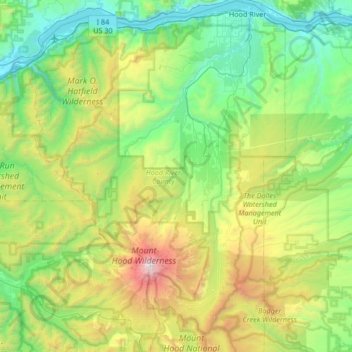
Name: Hood River County topographic map, elevation, terrain.
Location: Hood River County, Oregon, United States (45.25773 -121.92227 45.72651 -121.44058)
Average elevation: 2,822 ft
Minimum elevation: 7 ft
Maximum elevation: 11,115 ft
Hood River County is 533 square miles (1,380 km2), of which 522 square miles (1,350 km2) is land and 11 square miles (28 km2) (2.1%) is water. It is the second-smallest county in Oregon by area. Elevation ranges from 60 feet (18 m) above sea level at Cascade Locks in the northwest to 11,235 feet (3,424 m) at the summit of Mount Hood, the highest point in Oregon.
Other topographic maps
Click on a map to view its topography, its elevation and its terrain.
Portland
United States > Oregon > Multnomah County
Portland, Multnomah County, Oregon, United States
Average elevation: 253 ft
Salem
United States > Oregon > Marion County
Salem, Marion County, Oregon, United States
Average elevation: 315 ft
Eugene
United States > Oregon > Lane County
Eugene, Lane County, Oregon, United States
Average elevation: 535 ft
Hillsboro
United States > Oregon > Washington County
Hillsboro, Washington County, Oregon, United States
Average elevation: 174 ft
Newberg
United States > Oregon > Yamhill County
Newberg, Yamhill County, Oregon, United States
Average elevation: 200 ft
Lincoln City
United States > Oregon > Lincoln County
Lincoln City, Lincoln County, Oregon, 97367, United States
Average elevation: 154 ft
Newport
United States > Oregon > Lincoln County
Newport, Lincoln County, Oregon, United States
Average elevation: 108 ft
Gresham
United States > Oregon > Multnomah County
Gresham, Multnomah County, Oregon, United States
Average elevation: 295 ft
Hood River
United States > Oregon > Hood River County
Hood River, Hood River County, Oregon, United States
Average elevation: 367 ft
Roseburg
United States > Oregon > Douglas County
Roseburg, Douglas County, Oregon, United States
Average elevation: 784 ft
Bend
United States > Oregon > Deschutes County
Bend, Deschutes County, Oregon, United States
Average elevation: 3,678 ft
Grants Pass
United States > Oregon > Josephine County
Grants Pass, Josephine County, Oregon, United States
Average elevation: 1,227 ft
Corvallis
United States > Oregon > Benton County
Corvallis, Benton County, Oregon, United States
Average elevation: 266 ft
Redmond
United States > Oregon > Deschutes County
Redmond, Deschutes County, Oregon, 91156, United States
Average elevation: 3,028 ft
Lake Oswego
United States > Oregon > Clackamas County
Lake Oswego, Clackamas County, Oregon, United States
Average elevation: 285 ft
Florence
United States > Oregon > Lane County
Florence, Lane County, Oregon, United States
Average elevation: 72 ft
Oregon City
United States > Oregon > Clackamas County
Oregon City, Clackamas County, Oregon, 97045, United States
Average elevation: 325 ft
Mission
United States > Oregon > Umatilla County
Mission, Umatilla County, Oregon, United States
Average elevation: 1,407 ft
La Pine
United States > Oregon > Deschutes County
La Pine, Deschutes County, Oregon, 97739, United States
Average elevation: 4,232 ft
Astoria
United States > Oregon > Clatsop County
Astoria, Clatsop County, Oregon, 97103, United States
Average elevation: 49 ft
Klamath Falls
United States > Oregon > Klamath County
Klamath Falls, Klamath County, Oregon, 97601, United States
Average elevation: 4,304 ft
McMinnville
United States > Oregon > Yamhill County
McMinnville, Yamhill County, Oregon, 97128, United States
Average elevation: 164 ft
Ashland
United States > Oregon > Jackson County
Ashland, Jackson County, Oregon, United States
Average elevation: 2,539 ft
Albany
United States > Oregon > Linn County
Albany, Linn County, Oregon, United States
Average elevation: 233 ft
Amity Hills
United States > Oregon > Yamhill County > Amity
Amity Hills, Amity, Yamhill County, Oregon, United States
Average elevation: 354 ft
Bandon
United States > Oregon > Coos County
Bandon, Coos County, Oregon, United States
Average elevation: 72 ft
Washington County
Washington County, Oregon, United States
Average elevation: 699 ft
Estacada
United States > Oregon > Clackamas County
Estacada, Clackamas County, Oregon, 97023, United States
Average elevation: 577 ft
Prineville
United States > Oregon > Crook County
Prineville, Crook County, Oregon, United States
Average elevation: 3,045 ft
Silverton
United States > Oregon > Marion County
Silverton, Marion County, Oregon, 97381, United States
Average elevation: 338 ft
Catherine Creek
United States > Oregon > Union County
Catherine Creek, Union County, Oregon, United States
Average elevation: 3,609 ft
West Linn
United States > Oregon > Clackamas County
West Linn, Clackamas County, Oregon, 97068, United States
Average elevation: 243 ft
Douglas County
Douglas County, Oregon, United States
Average elevation: 2,283 ft
Sunriver
United States > Oregon > Deschutes County
Sunriver, Deschutes County, Oregon, 97707, United States
Average elevation: 4,304 ft
Willamette River
United States > Oregon > Polk County
Willamette River, Polk County, Oregon, United States
Average elevation: 236 ft
Silver Falls State Park
United States > Oregon > Marion County
Silver Falls State Park, Marion County, Oregon, United States
Average elevation: 1,808 ft
Anns Butte
United States > Oregon > Deschutes County
Anns Butte, Deschutes County, Oregon, United States
Average elevation: 4,304 ft
Dairy
United States > Oregon > Klamath County
Dairy, Klamath County, Oregon, 97625, United States
Average elevation: 4,265 ft
Pine Grove
United States > Oregon > Wasco County
Pine Grove, Wasco County, Oregon, United States
Average elevation: 2,339 ft
Sherwood
United States > Oregon > Washington County
Sherwood, Washington County, Oregon, 97140, United States
Average elevation: 223 ft
Tigard
United States > Oregon > Washington County
Tigard, Washington County, Oregon, United States
Average elevation: 272 ft
Milwaukie
United States > Oregon > Clackamas County
Milwaukie, Clackamas County, Oregon, 97222, United States
Average elevation: 161 ft
Pendleton
United States > Oregon > Umatilla County
Pendleton, Umatilla County, Oregon, 97801, United States
Average elevation: 1,319 ft
Mount Hood National Forest
Mount Hood National Forest, Oregon, United States
Average elevation: 2,605 ft
Brookings
United States > Oregon > Curry County
Brookings, Curry County, Oregon, 97415, United States
Average elevation: 430 ft
Trail
United States > Oregon > Jackson County
Trail, Jackson County, Oregon, 97539, United States
Average elevation: 1,752 ft
Sheridan
United States > Oregon > Yamhill County
Sheridan, Yamhill County, Oregon, United States
Average elevation: 279 ft