
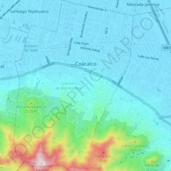
Coacalco de Berriozábal topographic map
Interactive map
Click on the map to display elevation.
About this map
Name: Coacalco de Berriozábal topographic map, elevation, terrain.
Location: Coacalco de Berriozábal, State of Mexico, Mexico (19.58848 -99.12879 19.66405 -99.07247)
Average elevation: 7,720 ft
Minimum elevation: 7,336 ft
Maximum elevation: 9,820 ft
Other topographic maps
Click on a map to view its topography, its elevation and its terrain.
Toluca
Mexico > State of Mexico > Toluca
Toluca is located at 2600 meters above sea level, being the highest capital city in Mexico and North America, which makes it temperate throughout the year with average temperatures ranging between 6 and 25 degrees Celsius during spring and summer, and from −5 to 20 degrees Celsius in winter. Its climate is…
Average elevation: 8,953 ft
Ojo de Agua
Mexico > State of Mexico > Tecámac
Ojo de Agua is the largest colonia in the municipality of Tecámac in State of Mexico, Mexico. It is located in the northeastern part of the state, northeast of Mexico City and within the Greater Mexico City urban area. It had a population of 386,290 people in the 2020 census. Ojo de Agua is the largest…
Average elevation: 7,536 ft
Popocatépetl
Mexico > State of Mexico > Atlautla
According to paleomagnetic studies, the volcano is about 730,000 years old. It is cone shaped with a diameter of 25 km (16 mi) at its base, with a peak elevation of 5,450 m (17,880 ft). The crater is elliptical with an orientation northeast-southwest. The walls of the crater vary from 600 to 840 m (1,970 to…
Average elevation: 15,781 ft
cuerpos de agua las cepas
Mexico > State of Mexico > Almoloya de Alquisiras > Progreso los Hernández (Colonia los Hernández)
Average elevation: 6,388 ft
Popocatépetl
Mexico > State of Mexico > Atlautla
According to paleomagnetic studies, the volcano is about 730,000 years old. It is cone shaped with a diameter of 25 km (16 mi) at its base, with a peak elevation of 5,450 m (17,880 ft). The crater is elliptical with an orientation northeast-southwest. The walls of the crater vary from 600 to 840 m (1,970 to…
Average elevation: 15,781 ft
San Nicolás Tolentino
Mexico > State of Mexico > Valle de Bravo > Valle de Bravo
Average elevation: 5,157 ft
Toluca
Mexico > State of Mexico > Toluca
Toluca is located at 2600 meters above sea level, being the highest capital city in Mexico and North America, which makes it temperate throughout the year with average temperatures ranging between 6 and 25 degrees Celsius during spring and summer, and from −5 to 20 degrees Celsius in winter. Its climate is…
Average elevation: 8,953 ft
Texcoco de Mora
Mexico > State of Mexico > Texcoco
Tescoco lies about 25 km east of the centre of Mexico City. Major elevations in the municipality include the Tlaloc Mountain (4,500 meters) the Tetzcutzinco, Moyotepec and Tecuachacho. Most elevations are named after the major community to be found on them. There are also a number of small canyons. Part of the…
Average elevation: 8,031 ft
Nevado de Toluca
Mexico > State of Mexico > Toluca
Most of the other sites are found on the crater's walls and peaks. One of the sites is called Xicotepec which is at the top of a rocky dome known as the Cerro de Ombligo (Spanish for "the navel"). Principally green obsidian blades and multicolored ceramic has been found here. On the north side of the crater is…
Average elevation: 14,042 ft
Valle de Bravo
Mexico > State of Mexico > Valle de Bravo
The municipality is surrounded by mountain ranges and other elevated areas covering about 50% of the total area and include the Sierra de Temascaltepec, Sierra de Tenayac, Sierra de Valle de Bravos as wells as the hills that roll around the mountain ranges. These elevations include a number of small volcanoes…
Average elevation: 6,280 ft
Barrio la Cascada (Barrio del Varal)
Mexico > State of Mexico > Temascaltepec
Average elevation: 6,142 ft
Ciudad López Mateos
Mexico > State of Mexico > Atizapán de Zaragoza
Its main elevations are Biznaga Hill, Atlaco Hill La Condesa Hill and Grande Hill.
Average elevation: 7,959 ft
Toluca
Mexico > State of Mexico > Toluca
The Lerma River flows from Lake Almoloya del Río through the center of the municipality towards the west, flowing into Lake Chapala. From this point westward the river takes the name of Río Grande de Santiago. And it goes from this lake to the Pacific Ocean in the state of Nayarit. The river is about 1,180…
Average elevation: 8,953 ft
Ojo de Agua
Mexico > State of Mexico > Tecámac
Ojo de Agua is the largest colonia in the municipality of Tecámac in State of Mexico, Mexico. It is located in the northeastern part of the state, northeast of Mexico City and within the Greater Mexico City urban area. It had a 2010 census population of 242,272 inhabitants, or 66.45 percent of its…
Average elevation: 7,536 ft
Santa María Tulpetlac
Mexico > State of Mexico > Ecatepec de Morelos > Santa María Tulpetlac
Average elevation: 7,480 ft
Predio de los Albertocos
Mexico > State of Mexico > Temamatla > Temamatla > Predio de los Albertocos
Average elevation: 7,589 ft
Ciudad López Mateos
Mexico > State of Mexico > Atizapán de Zaragoza
Its main elevations are Biznaga Hill, Atlaco Hill La Condesa Hill and Grande Hill.
Average elevation: 7,959 ft