
Bolikhamsai topographic map
Interactive map
Click on the map to display elevation.
About this map
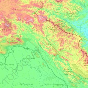
Name: Bolikhamsai topographic map, elevation, terrain.
Location: Bolikhamsai, Laos (17.86978 102.81023 19.12116 105.25881)
Average elevation: 1,732 ft
Minimum elevation: 23 ft
Maximum elevation: 9,117 ft
Bolikhamsai province has a rugged terrain, with large boulders and streams. Its elevation ranges from 140–1,588 metres (459–5,210 ft).[9] The principal river is the Nam Kading, meaning 'water like a bell', a tributary of the Mekong; its catchment covers about 92% of the provincial area.[9] The other main rivers are the Nam Muan, Nam Sat, and the Nam Tek.[9] Waterfalls of note include the Tad Leuk, Tad Xay and Tad Xang.[9] The longest mountain range in the province is the Phou Louang range, running to the southwest, the Phou Ao range to the southeast; the Thalabat range to the northwest, and the Pa Guang range to the northeast.[9] In Khamkheuth District, there is karst limestone scenery, which is allegedly the largest formation of its type in Southeast Asia. The many rock pinnacles have formed stone forest similar to limestone outcrops in southern China.[2]
Other topographic maps
Click on a map to view its topography, its elevation and its terrain.
Him
Laos > Houaphanh > Xam Neua District
Him, Xam Neua District, Houaphanh, Laos
Average elevation: 2,943 ft
Don
Laos > Sekong Province > Kaleum District
Don, Kaleum District, Sekong Province, Laos
Average elevation: 1,430 ft
Chommanytai
Laos > Vientiane Prefecture > Xaysetha District > Vientiane Capital
Chommanytai, Vientiane Capital, Xaysetha District, Vientiane Prefecture, 21001, Laos
Average elevation: 564 ft
Ban Khiau
Laos > Khammouane > Yommalath District
Ban Khiau, Yommalath District, Khammouane, Laos
Average elevation: 666 ft
Golden Triangle Special Economic Zone
Laos > Bokeo Province > Tonpheung District
Golden Triangle Special Economic Zone, Tonpheung District, Bokeo Province, Laos
Average elevation: 1,335 ft
Parkngum District
Parkngum District, Vientiane Prefecture, Laos
Average elevation: 814 ft
Naka
Laos > Houaphanh > Sop Bao District
Naka, Sop Bao District, Houaphanh, Laos
Average elevation: 1,106 ft
Bachiangchaleunsouk District
Bachiangchaleunsouk District, Champasak Province, Laos
Average elevation: 1,293 ft
Miam
Laos > Xiangkhouang Province > Phou Kout District
Miam, Phou Kout District, Xiangkhouang Province, Laos
Average elevation: 2,920 ft
Hinhurp District
Hinhurp District, Vientiane Province, 01000, Laos
Average elevation: 1,010 ft
Kham District
Laos > Xiangkhouang Province > Kham District
Kham District, Xiangkhouang Province, Laos
Average elevation: 3,553 ft
Keo
Laos > Xiangkhouang Province > Pek District
Keo, Pek District, Xiangkhouang Province, Laos
Average elevation: 3,947 ft
Bridge View Point
Laos > Luang Prabang > Luang Prabang District > Thapene
Bridge View Point, 2501, Thapene, Luang Prabang District, Luang Prabang, Laos
Average elevation: 1,709 ft
Na Sam Phanh
Laos > Sainyabuli Province > Phiang District > Na Sam Phanh
Na Sam Phanh, Phiang District, Sainyabuli Province, Laos
Average elevation: 1,709 ft
Muang Kham
Laos > Xiangkhouang Province > Phou Kout District
Muang Kham, Phou Kout District, Xiangkhouang Province, Laos
Average elevation: 2,500 ft
Vientiane Capital
Laos > Vientiane Prefecture > Chanthabuly District
Vientiane Capital, Chanthabuly District, Vientiane Prefecture, Laos
Average elevation: 614 ft
Thakhek
Laos > Khammouane > Thakhek
Thakhek, Thakhek District, Khammouane, 12000, Laos
Average elevation: 587 ft
Ban Phontiou
Laos > Khammouane > Ban Phontiou
Ban Phontiou, Hineboune District, Khammouane, Laos
Average elevation: 653 ft
ທົ່ງປົງ
Laos > Vientiane Prefecture > ທົ່ງປົງ
ທົ່ງປົງ, Vientiane Capital, Sikhottabong District, Vientiane Prefecture, Laos
Average elevation: 571 ft
Don-Kao
Laos > Luang Prabang > Don-Kao
Don-Kao, Luang Prabang District, Luang Prabang, 0600, Laos
Average elevation: 1,050 ft
Mout
Laos > Luang Prabang > Mout
Mout, Xiengngeun District, Luang Prabang, Laos
Average elevation: 1,247 ft
Sibounheuang
Laos > Vientiane Prefecture > Sibounheuang
Sibounheuang, Vientiane Capital, Chanthabuly District, Vientiane Prefecture, 01009, Laos
Average elevation: 561 ft
Khone Phapheng Falls
Khone Phapheng Falls, Khong District, Champasak Province, Laos
Average elevation: 243 ft
Chong
Laos > Salavan Province > Vapy District > Chong
Chong, Vapy District, Salavan Province, Laos
Average elevation: 558 ft
Phonthong District
Phonthong District, Champasak Province, Laos
Average elevation: 515 ft
Luang Prabang
Laos > Luang Prabang > Luang Prabang District
Luang Prabang, Luang Prabang District, Luang Prabang, 10000, Laos
Average elevation: 1,827 ft
Phanom
Laos > Luang Prabang > Luang Prabang District
Phanom, Luang Prabang District, Luang Prabang, 10000, Laos
Average elevation: 1,083 ft
Muang Kham
Laos > Xiangkhouang Province > Muang Kham
Muang Kham, Kham District, Xiangkhouang Province, Laos
Average elevation: 2,106 ft
Dan
Laos > Sekong Province > Dan
Dan, Lam Mam District, Sekong Province, Laos
Average elevation: 423 ft