
Tioga County topographic map
Interactive map
Click on the map to display elevation.
Tioga County
The highest elevation is an unnamed 1,994-foot (608 m) hill in the county's northern corner. The lowest is 720 feet (220 m) on the state line where the Susquehanna flows into Pennsylvania.
About this map
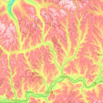
Name: Tioga County topographic map, elevation, terrain.
Location: Tioga County, New York, United States (41.99832 -76.56358 42.41033 -76.08012)
Average elevation: 1,286 ft
Minimum elevation: 417 ft
Maximum elevation: 1,972 ft
New York trails, hiking, mountain biking, running and outdoor activities
Other topographic maps
Click on a map to view its topography, its elevation and its terrain.
Saratoga Springs
United States > New York > Saratoga County > Saratoga Springs
Average elevation: 528 ft
East Hampton
United States > New York > Suffolk County > East Hampton > Village of East Hampton
Average elevation: 39 ft
Troy
United States > New York > Rensselaer County
The western edge of the city is flat along the river, and then steeply slopes to higher terrain to the east. The average elevation is 50 feet, with the highest elevation being 500 feet in the eastern part of the city. The city is longer than it is wide, with the southern part wider than the northern section of…
Average elevation: 449 ft
Watertown
United States > New York > Jefferson County
Watertown is around 60 miles (97 kilometers) northwest of Syracuse, 20 miles (32 kilometers) south of the Thousand Islands and 328 miles (530 kilometers) northwest of New York City. According to the United States Census Bureau, the city has a total area of 9.3 square miles (24 km2), of which 9.0 square miles…
Average elevation: 643 ft
Erie Canal
United States > New York > Erie County > City of Tonawanda
The construction of the Erie Canal was a landmark civil engineering achievement in the early history of the United States. When built, the 363-mile (584 km) canal was the second-longest in the world (after the Grand Canal in China). Initially 40 feet (12 m) wide and 4 feet (1.2 m) deep, the canal was expanded…
Average elevation: 581 ft
Tug Hill
United States > New York > Oswego Town
The core Tug Hill region encompasses 150,000 acres (610 km2) of unbroken, generally second-growth, northern hardwood forest, and is drained by a vast network of streams. Important rivers and streams whose headwaters are located within the Tug Hill region include the Mohawk River, Deer River, Salmon River, Mad…
Average elevation: 358 ft
French Mountain
United States > New York > Warren County > Town of Queensbury
Average elevation: 1,040 ft
Ward Pound Ridge Reservation
United States > New York > Westchester County > Town of Pound Ridge
Average elevation: 538 ft
Riveredge Trailer Park
United States > New York > Westchester County > Town of Cortlandt > Verplanck
Average elevation: 46 ft
Catamount Mountain
United States > New York > Saint Lawrence County > Town of Colton
Average elevation: 1,421 ft
East Williamson
United States > New York > Wayne County > Town of Williamson
Average elevation: 436 ft
Big Bear Mountain
United States > New York > Warren County > Town of Johnsburg
Average elevation: 2,021 ft
Eagle Lake
United States > New York > Hamilton County > Town of Indian Lake > Eagle Nest
Average elevation: 1,890 ft
Robinson Corners
United States > New York > Otsego County > Town of Edmeston
Average elevation: 1,398 ft
Pecksville
United States > New York > Dutchess County > Town of East Fishkill
Average elevation: 899 ft
Skaneateles Lake
United States > New York > Onondaga County > Town of Skaneateles
Skaneateles Lake (/ˌskæniˈætləs/ SKAN-ee-AT-ləs, locally /ˌskɪn-/ SKIN-) is one of the Finger Lakes in central New York in the United States. The name Skaneateles means long lake in one of the local Iroquoian languages. The lake is sometimes referred to as "The Roof Garden of the Lakes" because its…
Average elevation: 1,145 ft
Clinton, NY
United States > New York > Oneida County > Town of Kirkland > Village of Clinton
Average elevation: 623 ft
Onondaga Escarpment
United States > New York > Erie County > Harris Hill > Town of Clarence > Eastern Hills
Average elevation: 673 ft
Rotterdam Junction
United States > New York > Schenectady County > Town of Rotterdam
Average elevation: 531 ft
Stoodley Corners
United States > New York > Schenectady County > East Glenville
Average elevation: 351 ft
Sonyea State Forest
United States > New York > Livingston County > Town of Mount Morris
Average elevation: 758 ft
Isle of San Souci
United States > New York > Westchester County > City of New Rochelle
Average elevation: 23 ft
Kent Cliffs Unit
United States > New York > Putnam County > Town of Putnam Valley > Richardsville
Average elevation: 886 ft
Millers Corners
United States > New York > Rensselaer County > Town of Nassau
Average elevation: 689 ft
Brooklyn Bridge Park
United States > New York > New York County > New York
Brooklyn Bridge Park spans 85 acres (34 ha) of the East River waterfront in the Brooklyn Heights and Dumbo neighborhoods of Brooklyn. The park is divided into eleven sections: Piers 1 through 6; Fulton Ferry Landing; Brooklyn Bridge Plaza; Empire Fulton Ferry; Main Street; and John Street. Each of these…
Average elevation: 30 ft
Sherwood Park
United States > New York > Rensselaer County > East Greenbush CDP
Average elevation: 259 ft
Grovenor Corners
United States > New York > Schoharie County > Town of Carlisle
Average elevation: 1,099 ft
Inwood Hill Park
United States > New York > New York County > New York
Inwood Hill Park is a 196 acres (79 ha) public park in the Inwood neighborhood of Manhattan, New York City, operated by the New York City Department of Parks and Recreation. On a high schist ridge that rises 200 feet (61 m) above the Hudson River from Dyckman Street to the northern tip of the island, Inwood…
Average elevation: 46 ft
West Stephentown
United States > New York > Rensselaer County > Town of Stephentown
Average elevation: 1,306 ft
Balsam Mountain
United States > New York > Ulster County > Town of Shandaken
Average elevation: 2,746 ft
Shaker Crossing
United States > New York > Livingston County > Town of Mount Morris
Average elevation: 594 ft
Alamar Unit
United States > New York > Dutchess County > Town of East Fishkill
Average elevation: 912 ft
West Tiana
United States > New York > Suffolk County > Hampton Bays > Town of Southampton
Average elevation: 26 ft
Kings Gate Park
United States > New York > Rockland County > Village of Montebello
Average elevation: 505 ft
Montauk Station
United States > New York > Suffolk County > Town of East Hampton > Montauk
Average elevation: 36 ft
Black Creek
United States > New York > Monroe County > Town of Brighton > Genesee Junction
Average elevation: 525 ft
Big Slide Mountain
United States > New York > Essex County > Town of Keene
Average elevation: 3,425 ft
Just Room Enough Island
United States > New York > Jefferson County > Village of Alexandria Bay
Average elevation: 256 ft
Wykagyl Park
United States > New York > Westchester County > City of New Rochelle
Average elevation: 135 ft