Geolocate

Pyrenees topographic map

Interactive map

Click on the map to display elevation.

Pyrenees

The Pyrenees (/ˈpɪrɪniːz/; Spanish: Pirineos [piɾiˈneos]; French: Pyrénées [piʁene] (listen); Catalan: Pirineu [piɾiˈnɛw]; Basque: Pirinioak [piɾini.o.ak]; Occitan: Pirenèus [piɾeˈnɛws]; Aragonese: Pirineus) is a mountain range straddling the border of France and Spain. It extends nearly 500 km (310 mi) from its union with the Cantabrian Mountains to Cap de Creus on the Mediterranean coast. It reaches a maximum altitude of 3,404 metres (11,168 ft) at the peak of Aneto.

Wikipedia (CC-BY-SA 3.0)

About this map

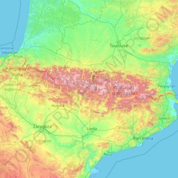
Name: Pyrenees topographic map, elevation, terrain.

Location: Pyrenees, Spain (41.72777 -2.07642 43.39906 3.32224)

Average elevation: 1,611 ft

Minimum elevation: -13 ft

Maximum elevation: 10,863 ft

Other topographic maps

Click on a map to view its topography, its elevation and its terrain.

Granada

Spain > Andalusia > Granada > Granada

Granada (/ɡrəˈnɑːdə/ grə-NAH-də, Spanish: , locally ) is the capital city of the province of Granada, in the autonomous community of Andalusia, Spain. Granada is located at the foot of the Sierra Nevada mountains, at the confluence of four rivers, the Darro, the Genil, the Monachil and the Beiro.…

Average elevation: 3,422 ft

Getafe

Spain > Community of Madrid

Getafe is located in the southern zone of the autonomous community of Madrid, Spain, in southwestern Europe. It is physically located in the centre of the Iberian Peninsula, north of the Southern Submeseta (part of the Meseta Central), in the Manzanares River basin. Its elevation is 610 – 640 meters above…

Average elevation: 2,073 ft

Fisterra

Spain > Galicia > Fisterra

Average elevation: 125 ft

Asturias

Spain

Average elevation: 1,854 ft

Mutxamel

Spain > Valencian Community

Average elevation: 338 ft

El Hierro

Spain

Average elevation: 689 ft

Lanzarote

Spain

Average elevation: 115 ft

Canillas de Aceituno

Spain > Andalusia > La Axarquía

Canillas de Aceituno has an altitude of around 524 meters at the foot of the Sierra de Tejeda and is crowned by the peak of La Maroma at 2,068 meters, the highest in the province. It is a town of narrow streets that are immaculately whitewashed, Moorish arches and corners of flowers.

Average elevation: 2,221 ft

Pineda de la Sierra

Spain > Castile and León

Average elevation: 4,692 ft

Urueña

Spain > Castile and León

Average elevation: 2,575 ft

Guardo

Spain > Castile and León

Guardo's average elevation is 1123 metres above sea level. The majority of the town is modern, mainly constructed during the first half of the 20th century, although there is a small historic section on a hill to the east. The centre of the town is on the left bank of the river. The right bank contains the…

Average elevation: 3,930 ft

Santanyí

Spain > Balearic Islands > Migjorn

Average elevation: 118 ft

Alcalá del Júcar

Spain > Castile-La Mancha

Average elevation: 2,293 ft

Cruz de los Martillos

Spain > La Orotava

Average elevation: 873 ft

San Roque

Spain > Andalusia > Campo de Gibraltar

Average elevation: 240 ft

Mendavia

Spain > Estellerria / Tierra Estella

Average elevation: 1,332 ft

Huelga del Escobar

Spain > Castile-La Mancha > Uña

Average elevation: 4,052 ft

Cardenete

Spain > Castile-La Mancha

Average elevation: 3,238 ft

Cervantes

Spain > Galicia > Os Ancares

These elevations are located in the nearby mountain ranges of A Trappe, Lóuzara, O Oribio, O Rañadoiro and O Piornal .

Average elevation: 3,255 ft

Alcossebre

Spain > Valencian Community

Average elevation: 131 ft

Torrecilla de la Orden

Spain > Castile and León

Average elevation: 2,546 ft

Talayuela

Spain > Extremadura

Talayuela is located in the north-east part of Extremadura autonomous community, in Tiétar river valley, an important tributary of Tagus river, and belongs to Campo Arañuelo comarca, next to La Vera comarca. That land is almost a flat valley, with an altitude of 287 meters above sea level.

Average elevation: 997 ft

Moron

Spain > Catalonia > Val d'Aran > Bausen

Average elevation: 3,478 ft

Camino de Santiago

Spain > Castile and León > Zazuar

Average elevation: 2,782 ft

Los Cristianos

Spain

Average elevation: 279 ft

Rionansa

Spain > Cantabria

Average elevation: 2,100 ft

Ávila

Spain > Castile and León

Ávila's position results in a warm summer mediterranean climate (Csb, according to the Köppen climate classification) bordering on a cold semi-arid climate (BSk) with warm summers and chilly winters with snowfalls. The hottest month, July, has an average temperature of 20.6 °C (69 °F), and the coldest…

Average elevation: 3,796 ft

San Pascual

Spain > Castile and León

Average elevation: 2,897 ft

Ubrique

Spain > Andalusia > Sierra de Cádiz

Average elevation: 2,008 ft

Donamaria

Spain > Baztan-Bidasoa

Average elevation: 1,841 ft

Callosa d'en Sarrià

Spain > Valencian Community

Average elevation: 1,070 ft

Castrillo de la Vega

Spain > Castile and León

Average elevation: 2,730 ft

Los Vegas

Spain > Andalusia > Valle del Almanzora > Serón

Average elevation: 3,025 ft

Bicorp

Spain > Valencian Community

Average elevation: 1,532 ft

Fornalutx

Spain > Balearic Islands > Serra de Tramuntana

Average elevation: 1,348 ft

Sayatón

Spain > Castile-La Mancha

Average elevation: 2,592 ft

Alquife

Spain > Andalusia > Comarca de Guadix

Average elevation: 3,937 ft

Chinchilla de Montearagón

Spain > Castile-La Mancha

Average elevation: 2,671 ft

Jumilla

Spain > Region of Murcia > Altiplano

Average elevation: 2,028 ft

Vilafamés

Spain > Valencian Community

Average elevation: 1,056 ft

Chelva

Spain > Valencian Community > La Serranía

Average elevation: 2,402 ft

Aras de los Olmos

Spain > Valencian Community > La Serranía

The climate: due to its altitude, this land has cold winters and hot summers, although with mild nights. The snow can sometimes be seen, forming beautiful landscapes.

Average elevation: 3,173 ft

Cáceres

Spain > Extremadura

Average elevation: 1,811 ft

Bocairent

Spain > Valencian Community

Average elevation: 2,477 ft

La Zubia

Spain > Andalusia > Comarca de la Vega de Granada

Average elevation: 2,825 ft

Alfafar

Spain > Valencian Community

Average elevation: 20 ft

Guadalupe

Spain > Extremadura

The Guadalupe River has its origins near the town in the Sierra de las Villuercas. Its highest point, the Pico la Villuerca reaches an altitude of 1603 m.

Average elevation: 2,503 ft

Montjuïc

Spain > Catalonia > Barcelonès > Barcelona

Average elevation: 128 ft

Xàtiva

Spain > Valencian Community

Average elevation: 571 ft

Carballedo

Spain > Galicia > Chantada

Average elevation: 1,890 ft

Jaén

Spain > Andalusia

Jaén has a hot-summer Mediterranean climate, closely bordering on a semi-arid climate with dry, hot summers and mild, moderately wet winters. Jaén has a July high of 33.7 °C (92.7 °F), with a very high average low of 21.4 °C (70.5 °F) with a mean temperature of 27.6 °C (81.7 °F). This is just shy of…

Average elevation: 1,988 ft

Aísa

Spain > Aragon > Jacetania

Average elevation: 4,491 ft

La Rosa

Spain > Navarre > Montejurra > Desojo

Average elevation: 1,729 ft

Gernada

Spain > Navarre > Pirinioak / Pirineo > Erro > Aurizberri

Average elevation: 2,999 ft

Piedrasluengas

Spain > Castile and León > La Pernía

Average elevation: 4,537 ft

Boada de Villadiego

Spain > Castile and León > Villadiego

Average elevation: 3,058 ft

Paiporta

Spain > Valencian Community

Average elevation: 69 ft

Ustés

Spain > Navarre > Pirinioak / Pirineo > Navascués/Nabaskoze

Average elevation: 2,523 ft

Atalaya

Spain > Extremadura > Zafra - Río Bodión

Average elevation: 1,568 ft

Meneses de Campos

Spain > Castile and León

Average elevation: 2,467 ft

Olesa de Montserrat

Spain > Catalonia > Baix Llobregat

Average elevation: 722 ft

Garaioa

Spain > Navarre > Pirinioak / Pirineo

Average elevation: 3,225 ft

Buñol

Spain > Valencian Community

Average elevation: 1,588 ft

Almendralejo

Spain > Extremadura > Tierra de Barros

Average elevation: 1,089 ft

Covarrubias

Spain > Castile and León

Average elevation: 3,337 ft

San Sebastián de Garabandal

Spain > Cantabria > Rionansa

Average elevation: 2,201 ft

Villasuso

Spain > Cantabria > Cieza

Average elevation: 1,365 ft

Jaca

Spain > Aragon > Jacetania

Jaca has a submediterranean climate (Köppen: Cfb) bordering a submediterranean climate (Köppen: Cfa) with strong continental influences caused by the city's high altitude of 820 metres (2,690 ft). Winters are cool and summers are warm, with hot daytime temperatures but relatively cool nights. There isn't any…

Average elevation: 4,012 ft

Aneto

Spain > Aragon > Benasque / Benás

Average elevation: 9,596 ft

Cervià de Ter

Spain > Catalonia > Gironès

Average elevation: 210 ft

Lavizán

Spain > Cantabria > Valderredible > Revelillas

Average elevation: 3,084 ft

Santander

Spain > Cantabria

Average elevation: 33 ft

Merlín

Spain > Galicia > O Deza > Agolada

Average elevation: 1,890 ft

Valdés

Spain > Asturias

Average elevation: 1,086 ft

Requena

Spain > Valencian Community

Average elevation: 2,283 ft

Mieres

Spain > Catalonia > Garrotxa

Average elevation: 1,306 ft

Salamanca

Spain > Castile and León

The city is located at an altitude of 800 meters above sea level. The altitude of the municipality varies from 911 meters (Los Montalvos), in the southwest, and 763 meters in the last stretch in the municipality of the Tormes river.

Average elevation: 2,664 ft

Corteconcepción

Spain > Andalusia > Sierra de Huelva

Corteconcepción is a town and municipality located in the province of Huelva, Spain. According to the 2005 census, it has a population of 620 inhabitants and covers a 49 km2 (19 sq mi) area( people/km²). It sits at an altitude of 572 m (1,877 ft) above sea level, and is 114 km (71 mi) from the capital.

Average elevation: 1,535 ft

Palma

Spain > Balearic Islands

Palma is a major city and seaport located in the southwest of Mallorca, a western Mediterranean island belonging to the Balearic Islands archipelago. The land area of the city is about 21.355 square kilometres (8.245 sq mi) with an altitude of 13 metres (43 feet) above sea level.

Average elevation: 161 ft

La Parra de las Vegas

Spain > Castile-La Mancha

Average elevation: 3,209 ft

Titaguas

Spain > Valencian Community > La Serranía

Average elevation: 2,894 ft

Campanario

Spain > Extremadura

Average elevation: 1,161 ft

Fernandino

Spain > Castile and León > Gallegos de Argañán

Average elevation: 2,408 ft

Pico de Urbión

Spain > Rioja > Viniegra de Abajo

Average elevation: 6,535 ft

Vilobí del Penedès

Spain > Catalonia > Alt Penedès

Average elevation: 860 ft